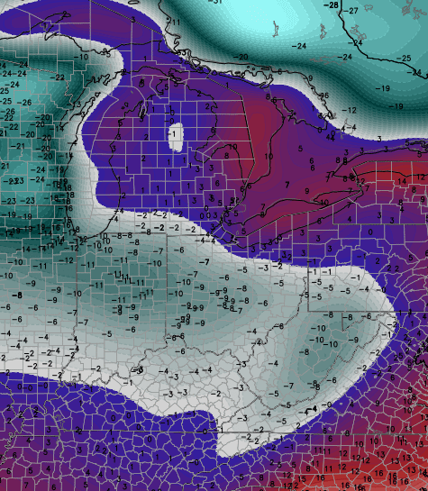
Good afternoon, gang. Cold air continues to push eastward across the bluegrass state and this is a sign of things to come. I mentioned a few days ago that this was a pattern to where the models would be too warm with the temps and we’re already seeing that.
The numbers across central and western Kentucky are several degrees colder than model forecasts from just a few hours ago and MUCH colder than model forecasts from a few days ago.
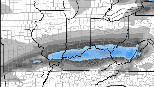
Temps this afternoon will stay in the mid 30s for the west and central . Thermometers in the east will slowly drop into the upper 30s. Rain will continue as another wave of low pressure works along our cold front. That may have a touch of some snow and rain mix showing up on the western fringe though the evening…

Current temperatures

Monday will feature more clouds, but with some breaks trying to show up. Highs will be in the upper 30s to low 40s.
Some flurries will still be possible Tuesday as even colder air sweeps in. A period of light snow may develop across far eastern and southeastern Kentucky during this time.
The final day of 2014 will be a cold one with some areas struggling to get out of the 20s for highs. Looks like upper teens and low 20s as the ball drops on 2015.
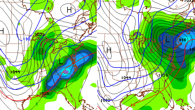
The end of the week storm system continues to show up very well on the models and we are seeing them finally sensing the arctic air. How are they doing that? By no longer cutting a storm all the way to Chicago and, instead, pushing it much farther south and east. That’s obviously a colder solution for our part of the world.
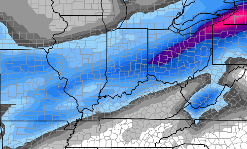
The European Model continues to indicate a swath of winter precipitation for much of the state on Friday…
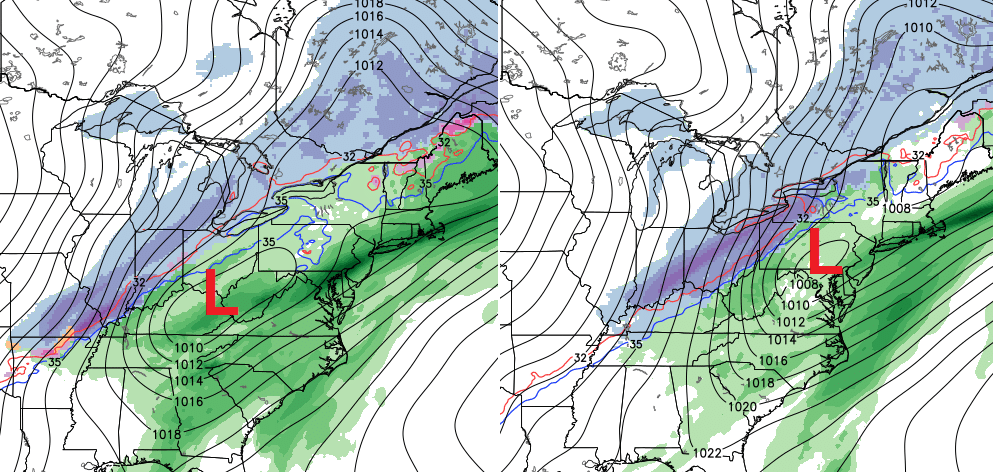
Again… that’s showing where a mix of precipitation falls on this particular model run. The European Model then shunts the system eastward with a switch to cold rain then back to some snow to end things late Saturday.
The Canadian Model offers a similar solution with a mix of precipitation on Friday then to rain then to some snow late Saturday…
The new version of the GFS is trending in a similar direction…
As the models continue to finally catch on to the fact they are busting WAY too warm on temps across the country and North America… can that system wind up more south and east than the current model forecasts? That’s something to watch for in the coming days.
Whatever happens with that system, a true arctic front looks to sweep in behind that and could develop a wave of low pressure along it…
I want to stress… individual storm systems and arctic blasts will differ on timing and impact on our actual weather. But… this overall North American pattern is a COMPLETE AND TOTAL reversal of the one we had for most of December.
Enjoy your Sunday and take care.

Are we going to have an extended cold period? Temps seem to be going up and down…
I am groovy with anything but ice rain 🙂
Snapshot December and make it January as long none of that stuff. Have become easy to please 🙂
You’ve given up. 😉
True, but gotta spin it 😉 🙂
BubbaG….I go with the flow these days. No hype from me unlike the frenzy some of us put ourselves through in the past on this blog! I’ve changed my ways to the “whatever” attitude! AND Hi MikeM!?
The models are useless right now. Here in east TN, it was supposed to be raining all day today, with 1.5-2 inches shown yesterday. We’ve only had light drizzle and barely a quarter inch fallen so far. If the models can’t forecast a day in advance, how can we trust them a week out?
Rodger hoping this will all come together for some winter fun. Consider him very cautiously optimistic. Two weeks of cold and white would cheer up this blog considerably. Rodger!
The Canadian and the Euro the picture there painting just not going too happen. System this weekend may start off as a mix but the majority of this system will be rain shame to gulf is wide open. Open gulf warm air convection warm front strong low pressure= Rain. Don’t fret after the system departs and drops a inch or two of rain Canadian high pressure will move on in and give us a cold dry Sunday.
Looks like the same ol’ song & dance for the Southern counties.
The NAM was hinting of some light wintery precip on Tuesday yep that’s no longer.
The models are using the Rolocoaster method of weather prediction. Throw something out there and see if it sticks. Even a blind squirrel finds an acorn every once in a while.
Forecasting is tough and uncertain work… I had some friends back out of a camping trip (survival man style – build a shelter and a fire…) due to today’s rain (1 plus inches) that was in the forecast yesterday. Well – no rain today, only slight mist and I am sitting at home bored with the great outdoors wondering where I am…
1.28 inches of rain here
Wonder how it was in Powell, Wolfe, Menifee county area?
I keep trying to find the like button!
Question is, what would you weather fans want more: blowtorch weather in January with 50s and an occasional 60 degree day, or the status quo, dreary, rainy, 40 degree days?
Every other source I’m following is going with a quick hit of cold with a RAIN event next weekend.
Sorry gang, not happening this year
My prediction of <10" of snow for Jackson and London looks great
Ridiculously foggy on 75 and around many places. Fog Advisory looks needed or at least mentioned as a possibility for people.
The first post today, talking about all of the model waffling on what is going to happen *tomorrow night*. Unbelievable. Ugh. Every year, instead of getting better, it seems to be getting closer and closer toward simply looking at what’s happening on the radar somewhere in the direction of where the weather is coming from and just reporting it.
If only meteorology was treated as seriously as it needs to be and given the resources it deserves. Honestly, given the crap data modeling CB and others have to work with daily, it’s a genuine miracle there’s ever a right forecast about anything. Sorry CB.
Simply stated, you are correct. CB does a great job with the crap models he has to work with. Haven said that, it doesn’t matter how technically advanced we become or how much money and resources are thrown into meteorology and models…..mother nature will ALWAYS be one step ahead. If mankind lives and advances 1000 years from now, no man or machine will ever be able to get within 75% or better accuracy in predicting the weather. It is what it is…..
Ive given up completely. I accept weather is cyclical and global warming has merged into the cycles to make winter that has snow in it for mid south east kentucky extinct. We have had one decent snow since 1998. in my 18 years here before that winters were cold and snow. May I dream one day of a White Christmas and Winter once more.
El Nino winters usually arrive late..Give it time fellow bloggers give it time..The rubber band is stretching and it’s about to go snap..There is light at the end of the tunnel..Hopefully it’s not another train..lol
I haven’t totally given up hope on snow this winter but, after seeing storm after storm show up on the models then fizzle away before it arrives, I’m a bit skeptical of anything the models are showing right now. My forecast for the late week/weekend storm: chilly with 100% rain. Perhaps the 3″ we got in November was all she wrote for this winter season. Perhaps there is a surprise awaiting us for Jan-Feb-Mar. Only time will tell. Let the Nowcasting commence!
GFS looking awfully rainy next seven days. Wouldn’t get my hopes up people. Temps look seasonable at best.
Accuweather post today confirmed the snow drought in the east today. I guess it is true, misery loves company. No mention of snow in the forecast for the next week. Push the artic blast back another week. I think we end up less than 5 inches for the year.
Rain, rain, looks to stay significant snow not likely over this a way.
Hey at least we have had a good 0 inches so far. This could turn out to be the second winter I remember where I never see snow. (The first wasn’t even in America – It was when I lived in England!) But it is early… We’ll see.
a couple harsh winters In a row , a 3 rd seemed unlikely, oh well lets hope one good snow 6 plus would make the the winter for me, then bring on spring and put this sad winter to bed!
Sad winter? It’s barely a week old and you’re giving up already?
I guess 15 years of no big block busters has me sceptical on our chances :