Good Sunday to one and all. We have a cold front pushing across the state today and this will lead the charge on a series of fronts this week. Each of these fronts will usher in colder air than the one before it. Eventually, arctic air will begin to surge in behind these fronts as the month wears on.
Today’s front passes through pretty early this morning with a band of rain and snow showers behind it. The air coming in behind this isn’t super cold with the east in the upper 30s to low 40s. The west will see a quicker return to sunshine and thus some milder air.


Monday’s weather looks pretty good with some sunshine and pleasant temps. Winds will gust up as another system approaches from the northwest. The Canadian Model is developing a nice wave of low pressure along this boundary…
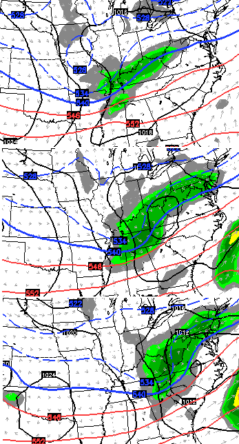 The Canadian then tries to bring back the big storm system rolling across the south and then near the east coast…
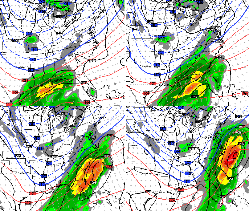
We will see how that looks in the days to come. The European looks similar with that system, but follows it up with this…
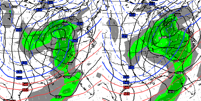
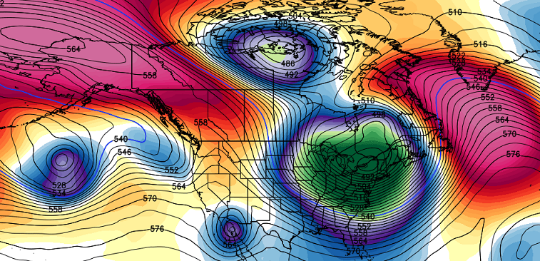
The longer range continues to look cold with arctic air rolling back into the country. That trend starts later next week then kicks into high gear thereafter. Check out the crazy blocking showing up on the GFS Ensembles…
Yowza!
I will have updates later today. Take care.

I am going out on the limb here and saying…..Artic air? I dont think so…40s and 50s from now til March and then 60s and 70s except for a day or so….:)
AKA Brian lol
who knows you might be right.
I think the snow was over in November LOL….face it Chris….winter in Ky. sucks 🙂
I think winter still has some surprises left.
Any years I can remember really big snows (in my lifetime) were years that featured almost no snow beforehand.
Correct 😉
I keep thinking back to winter of 97-98.
Only 4 or 5 inches going into Feb. and then the hammer down with officially 22.3″ at the airport in Louisville between Feb.4th and 6th. Some places received even more.
That was the freak storm where we were getting the energy for all the snow from the Atlantic Ocean. It is also the storm that the eve before (Feb 3) Tom Wills came on and said an inch or less of total accumulation expected. (Ooops).
I remember getting up in the middle of the night and catching a weather update with him saying “maybe 1” and looking out on my balcony in Old Louisville to see over 3 already. This is when I realized the one thing our weather guys didn’t have/use was a window.
The 2004 storm was truly unique setup that I’ve never seen before with the moisture being fetched back west into the midwest from the Atlantic. The mets in the Evansville market totally missed it too.
Not to bust perception bubbles, but prior to 98 we had at least three big snow events in each decade since the 1960s. We now are approaching two decades without an event- unless north 64 or east KY. The fence is holding firm it seems.
From a trend standpoint the over 1.5 decade gap is really bad as far as forecasting ahead. We could go years without another big event.
Unless ice.
Thanks Chris. Kind of chilly and damp out there right now.
Has an early spring feel.
I’m sure hoping we can wrangle a snow or two before winter’s over.
Good Sunday to all!
*Check out the crazy blocking showing up on the GFS Ensembles…that will most likely be lost on future runs.
FIFY
I’ve tried to remain optimistic, but geesh! The Pacific SST setup is as good as we could have hoped for this winter and nada so far. According to Joe Bastardi, this type of setup is only rarely seen. It happened in 1958 and again in 1978. So what gives?
I have no clue, but I suspect the warm Atlantic is causing some of out problems. Regardless, there just hasn’t been a lot of moisture to produce snow or rain. The Modiki setup in the El Nino region should be good for that, but again nothing.
What’s strange is we just went to through the warm phases of the MJO and it was cold. Now, we’re into phase 7, a cold phase as are 8 and 1, and it’s going to be mild for a time. Everything seems to be turned upside down.
I think the answer has something to do with increased solar activity that appears to impact blocking…don’t know what else it could be as the set up should have given us a harsh winter
That makes too much sense! 🙂 Solar activity has thousands of times more impact on our weather than anything man-made, but such logic and reality is bad for manbearpig$.
Well perhaps the freakish upside down’s will end up bringing is a freakish rare crazy snow storm soon..
I’m not complaining. Wouldn’t mind seeing a big snow, but the electric bill has been a lot easier to pay this winter. Everything this winter seems to be happening the week after next, and then when that gets there it is pushed back another two weeks. The thing is that eventually those week after next cold and snow coming from the models is eventually going to run into March. Average highs for mid-February start creeping up into the 50’s in Southern Kentucky, so temps start to become an issue with every system coming in. It might happen, but I’m at the point that I’m okay either way.
Thanks Chris and loving the winter look. Hope that can bring snow.
I was just over on weather.com and they have 50% chance of snow showers on Wednesday now. And they had a story about the east having below average temps Feb-April. Looks like they may be seeing what you were and are seeing. Accuweather seems to have brought temps down to average or lower for the extended range as well.
I like big snow. But I remember having no snow a few times in HS up until late January-Early February. Then winter decided to bring it all at once. And it was cold enough it stuck on for a good while. We missed a lot of school. Really hope that they do not miss a lot this year. Do not think my son wants to graduate and go directly into college. A few weeks off might be good for him.
In response to my: “I was just over on weather.com and they have 50% chance of snow showers on Wednesday now” strike that. It has changed again and they show 60% chance of showers. I am wondering what they will show in the morning, lol. Seems to change multiple times a day. I know it is a few days away but I have seen 2 day away forecasts do this. And I know weather is hard to predict to some extent but they change more than anyplace I look.
Snow lovers be patient. The snow will come. Might be next winter, but the snow will come. Ha ha. I like the looks and how the models are all coming around to a cold few weeks coming up. I have to travel back to back weekends to Indy and then to the Smokies. I am sure it will snow somewhere while I am on the road.
Thanks for the update CB! Go Packers! Go Indy!
49 degrees and climbing here in southern KY with a second day of beautiful sunny skies. I’ll take this weather and be tickled. May not reach yesterdays temps but it’s still worlds better than the 33 degree rain we have had 4-5 out of 7 days every week since November.
Whether the Colts win or lose, I’d stay off the streets in Foxboro after the game as I’m sure the Colts owner will be driving himself somewhere.
I’m glad I had 2 days of 50+ degree days despite prognostications suggesting other wise
I’m enjoying these January days in the 50’s. The models seem to be overplaying the cold right now. I’m hoping that by the time March gets here we can at least get seasonable weather. Would be nothing worse than a winter with no snow, to have a cold spring.
If you refer to Chris as such, then you are wrong.
Don’t think I mentioned CB anywhere in my post. Comments like this make people not want to post on here. Pretty obvious the maps overplayed the cold today. Sorry for stating that. Geez.
He was posting on what Andy Rose. I had no problem with Andy’s post but your right, Most of Hamlins comments make people not want to post anymore.
I have not said anything deserving of such a false comment as yours.
I suppose I am in the minority, but these sunny 50 degree days can hold off until spring. I biked yesterday and saw so many people out and about. I bike or walk every day of the year. The last month I have rarely seen anyone outside. July and August also sees a decline in folks outside. I don’t think people understand that it is still possible to enjoy the world outside when it is rainy, cloudy, and cold or even hot, humid, and sunny. Anyway. I miss winter. I just read 2014 was the hottest year in 5000 years, not just on record. I need to come to grips with April in January I guess.
I will have top disagree with part of your statement…..only a frog or a mosquito can enjoy the world during constant rain. lol
Right on!!! I’ve commuted by bike everyday since May 2, 2013!!!! Foul weather is just as good as any at this point! It has completely changed my life. Keep that stoke and live for the day!!!
There is not much snow anywhere, so not just the usual Kentucky fence for big events. Just smaller snows around us and we get nothing. Still relative, but not like much has missed, since nothing to miss.
Lucy is sad since nothing to spot up on.
What Chris failed to mention to you snow lovers is the wave of low pressure developing on the boundary for mid week looks to be all rain maybe a little mix on the north side. I would love for a mild snow less rest of the winter!! Today and yesterday and even Friday have been great.
feels like winter has just worked extra hard to bust the winter forecast. since november we ve been relatively warm. Everytime a model shows it getting cold it just doesn’t happen. Chris I wouldn’t want your job man. Its gotta be tough to be a weatherman.
Overall it has been a pretty cold January. It was below zero just last week (which is unusual around here)
November was warm? I thought November was colder than normal from what I had read. Maybe not. I am sure that December started off somewhat colder. I know that forecast highs where missed low. The models in early December where showing warmer than temps we actually had. And early January had be pretty cold. Cold enough the ground was frozen.
Another thing I find odd is that I had seen forecasts for the second half of January and February being warmer than normal. I have heard some family and friends repeat that. But then I see the forecasts being reduced and some of those places actually have articles about February-April being below normal now.
I think this year has been an outlier to past winters. Everyone is reading things as with this and that lined up we should be getting this type of winter, but its just not happening. The climate prediction center went from a cold outlook to a normal outlook for the months ahead within the last week, and if you look back today it may be cold again. I’m just going to look out the window.
Yowza is right… if I am reading the lines right (kind of hard to see) that is a 486 thickness over western NY… holy cow!