Good afternoon, gang. Old Man Winter is showing some serious signs of life as we track a couple of systems later this week into the coming weekend.
Let’s start with a storm system developing across Texas. This bad boy has been well telegraphed for more than a week, but the track on it has varied. Many of the models over the past several days have been showing this storm tracking well to our south and east. That is now changing.
Let’s review the track of this storm on some of the latest model runs. The GFS snow brings a lot of precipitation into our region…

Much of that would fall as wet snow Friday into the first half of Saturday. The NAM only goes out through Friday evening, but has a similar overall look…

The European Model started the trend of bringing this system farther north and west, but the latest run is just a tad east…
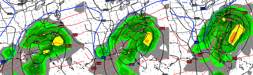
That’s still a good hit of wet snow for parts of our region as the storm wraps up along the east coast.
A few trends are becoming apparent… 1. This looks like a stronger storm 2. Because of that, it takes a farther north and west track and impacts Kentucky. Again, that’s the current “snapshot” of how things are looking. Stay tuned.
The system that follows that up late in the weekend is also showing up stronger with more of an impact on our weather. We have a hefty upper level system diving into the eastern trough as a BIG ridge develops along the west coast…
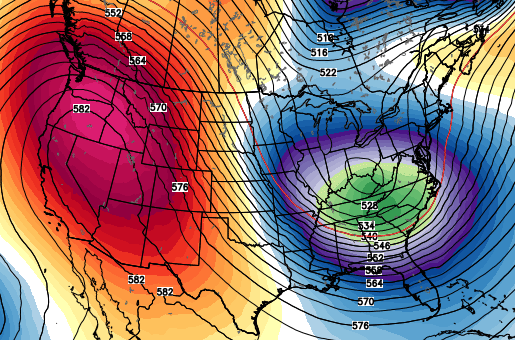
On face value… that’s a nice setup for snow across our part of the world. As you know, I’ve been focusing more on the upper levels with this weekend, but the lower levels are now catching on. Here’s the European Model…
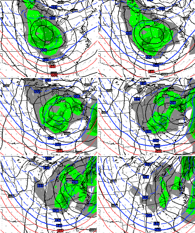
The GFS isn’t too far behind…
IF the upper level forecasts are right… IF… then the surface system may continue to trend deeper in the coming days. I suspect a lot of that may be determined by what happens with our Friday/Saturday storm across the east.
At least we are getting something to talk about now. 🙂
For all you weather history buffs… does today’s date ring a cold bell? On this date in 1985 we had one of the coldest days on record in Kentucky. Lows were close to -20 in many areas and some would duplicate that again the following morning. Quite the difference out there some 30 years later.
Enjoy the rest of the day and take care.

BubbaG….those maps are refreshing! Could it be the end of many trends. Wait and see.
Thanks for thr update Chris!
Only mother nature and Rolo’s goats really know 🙂
Too funny!
they are? Looks like the same ole same ole.
No soup for you!
Since its the same ole soup I’m OK with that. 😉
hehehe, Cla*sic! Post of the day for sure!
Hoping it snows!!!
perfect scenario this Sunday night and Monday morning for storm with accumulating snow – could be one of those heavy, wet snows that breaks trees and snaps utility poles. something to definitely keep eyes on !!
Heavy wet snow sounds about right for the larger snows in my end of the state (eastern)
I am more interested in the northwest system.
I do not trust anything coming out of the south.
January – February 1985 Winter = Epic
Love the 80’s.
Yup, I remember this day in ’85 quite well as I working on a horse farm. The temperature got down to around -20 around mid afternoon. We’d go around from barn to barn and give the horses a quick drink of fresh water as the water in their buckets would be frozen solid in no time at all. We had a mare and her foal that had just shipped in from Florida and she was so cold. We had her and the foal wrapped up in layers of blankets and had bandages on her legs. Even had a large human coat wrapped up on the colt.
hmmm the famous NW shift being a good thing??? that would definitely bust a lot of trends
who knows
this winter has been all upside down.
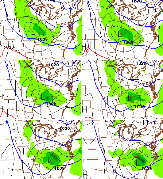
the low coming down from the north west.
I love to see the low pressure Center in eastern Missouri instead of central Kentucky.
Got a feeling before all is done Friday/Saturday system will dry up..Seems like everything that tries to get organized this horrible winter wounds up being a strung out piece of crap..Clipper might be our only hope to see some snow this Jan..
Temps are a concern with a NW shift. It’ll prolly shift too much and put us in southern ky in another cold depressing rain.
A few minutes ago, I saw a weather map that had rain from Morehead, to Lexington to around Bowling Green. A 20 to 30 mile mix to the north of that and light snow from that to the river. Nothing in southern Indiana. So according to this map, mostly rain in most of Kentucky.
I’ve loved the last few days. Reminded me of typical January weather in New Orleans when I lived there. One good snow would be OK, but please, no polar vortices, arctic invasions, or ice. Hate that crap.
You got it William!
I live far side of western kY by the river. Local weather man is saying rain in the forty’s Sunday. But he did say that subject to change depends on the track of storm.CB when this big cold air supposed to arrived that’s one thing he never mention
Sounds interesting for sure. But as Chris said….let’s take the wait and see approach. But I’m hopeful. I remember the cold in ’85 too. We were trying to dig up a busted water line in 36 inches of frozen ground! NOT fun!
Chris Bailey –
When we attempt to make a comment, and it disappears and doesn’t post, do you actually see that comment and it awaits your approval, or is it a bug in the system?
A bug
I think you should address the issue with your readers at least saying it’s a bug and that some corrections might be needed in order to post a comment.
BTW, you are awesome!
As Dandy Don Meredith used to say, “if ifs and buts were candy and nuts, what a Merry Christmas we would have!” Hope you are right CB!
Not buying into the 18z nam not falling into that trap this early in the game. If the nam still painting this picture by this time tomorrow night then and only then will I take heed.
I 64 NORTH/NW might see couple inches on backside as it pullds away.. rest rain.. nothing see here
I want 4-5 I love snow
Snow is a buet
Hope you get what you want