Good Wednesday, everyone. After a heck of a run of a whole lot of nothing to talk about… it looks like we are flipping the page in a big way. A developing winter storm across Texas will track across the south and then turn the corner up the east coast this weekend. The track of that low could put Kentucky in the line of fire for accumulating snow.
COULD is the key word in this because it’s all about the track of the low. We are now inside 2 days away from this system possibly impacting our weather, so this isn’t like we’re tracking something that’s a week away. The closer we get to this potential… the greater the risk showing up on the models.
Let’s start with the GFS. Here’s how that model tracks the storm Friday into Saturday…
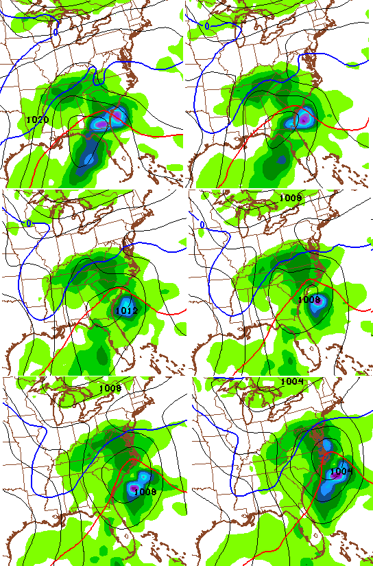
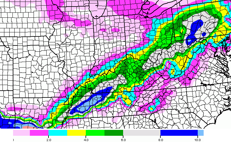
That’s primarily a wet snow maker showing up on that model run. Here’s the snowfall forecast from the GFS…

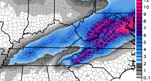
The NAM is very similar to what the GFS is showing with the overall track and intensity of the storm, but has more moisture to work with…
With more moisture, you would expect the model to have a healthier snowfall forecast. Sure enough…
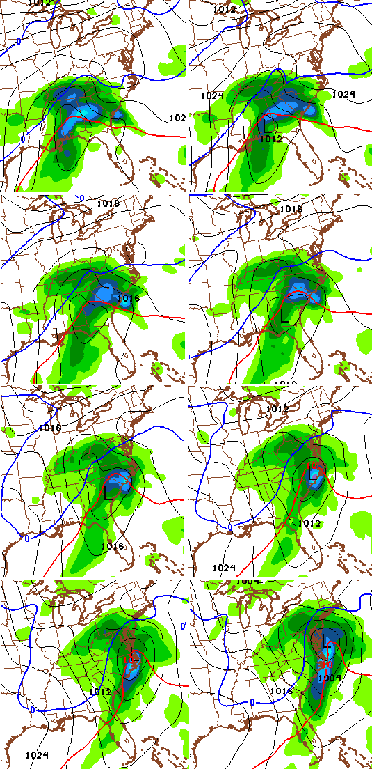
These models aren’t alone in showing some kind of snowy hit across the bluegrass state. The Canadian Model was the last holdout, but decided to jump in last night. The European Model was the first to catch on to the farther north and west track and it continues to show the same.
I want to stress… all of the above maps are from computer models that change from run to run. Those ARE NOT maps I made as a forecast! That said… if I continue to see similar trends, a Winter Storm Threat could be in the making later today.
The late weekend system still looks on track to dive in here, but I’m all in on focusing on the first potential for Friday and Saturday.
I will have updates as needed today, so check back. Have a great Wednesday and take care.

Whoop, whoop! Rodger came out of hibernation when he saw these model maps. Let’s hope one of them is close. The NAM looks best at my house! Rodger in Dodger!
Only 2 days out, please hold, we need this.
I can’t even begin to explain how excited I am that we are finally seeing the POTENTIAL again for some snow. Let’s hope Old Man Winter comes through for us!
I know Damaged Goods – I mean, even if this is a bust and doesn’t verify, at least there’s potential.
Even the nws in jackson is talking about this one and how there is potential for snow accumulations that’s saying something as they are fairly conservative when forecasting winter weather
The first snowfall model map would put Berea as the geographic center of the heaviest snowfall zone.
That might be the funniest thing I’ve seen in a while.
#theateroftheabsurd
Looks like a very cold rain for 90% of the state. The river counties will get the brunt of the snow once the NW shift comes into play. Unless all the trends of the last decade are broken those maps are teasers. I am suppose to travel to Indy Friday night so I hope for all of you, all who NEVER get snow South of the river, that this storm tracks just as planned above and the trends are broken.
Thanks Chris for the update I see the a threat map coming out later today.
Well, if we go by actual results and use that to weight a forecast of the models- yep. But the men in black zapped us all with their pens and it’s all new an shiny. Weeeeeeeeeeeeeeeeeee!!
😉 🙂 🙂
Trends are trends and I am not sure if the Men in Black can even change this one!!!
You saw what Rolo’s goats are calling for. We are all on then same page at least!
sticking to I 64 N/NW get any snow.. possible heavy rain for rest..
Even if some snow falls, the nws has Wayne County & a good part of the area back into the 40’s Saturday & Sunday…snow to rain & a whole lot of yuck! If there was a way to hold temps to freezing then obviously it’d be a different story.
well lets see what the models do this afternoon and tonight, not saying we will get a blizzard, but the chances are good for a 1-3 maybe 2-4 and if trends continue 3-6 around Berra-Richmond area. But I am not a meteorologist so take my opinion with a bit of salt and honey.
Tom you don’t listen to BubbaG, do you. If your south of the river no snow for you. Ha ha
It ain’t me, but the actual results. Snap!
True Dat!
No soup either;)
🙂
Looks like we could get something out of this storm. Hope the ground temps are cold enough for some accumulating snow. Even TWC is jumping on board this one, now. I think CB called it first. Snow…..yes!
I give up predicting. I thought the Cats would blow Vandy out of Rupp and they almost lost, so my crystal ball needs a real good polish. That or sold at a yard sale.
Zone Defense Bubba is UK’s kryptonite
We went from nothing much, just a minor clipper yesterday, to a possible winter storm threat today! I remember Brian Goode from WAVE saying if any of these systems become something more, it will likely happen within a couple of days of the event. Exactly that happened. But even still, I have noticed that happens with a lot of systems, like the 5″ March 2012 event, models went from traces of snow to 6″ one day before it hit.
Actually this has been showing up for quite a few days..Guess Chris just gets tired of the complaining about all the rain we will get when snow is showing up 5 days out..
well looking things over this AM and the FRI/SAT looks to miss mostly to south.
Perhaps why no update from CB yet. He might be wanting to see if that trend continues. If it was still looking to smack us, we would have at least got a morning tweet as such.
I went to a CB 101 behavior course 🙂
Too early. Besides he normally posts after Micha Harris gives his thoughts at noon.
Goat speak? 😉
We can get three cans. Use a marker and write on one “rain”, “mix” and “snow”.
Which ever can is chewed on by the goat is the forecast 🙂
Hoping the track moves about 50-75 miles SE.
NW….Don’t you know anything. Lol
No. Sorry, I’m feeling stingy today. The maps that CB shows needs the storm to move back to th SE for my area to get a direct hit. 😉
I am trying really hard to not get excited !!! Would love for my kids to see some snow in Southern KY !
The Cats are 18-0. Still goes down as a win. I think they may be underestimating some of their opponents. Last years team would had lost last nights game,Ole Miss and the Texas A&M game. I don’t believe we go 40-0,but this years team has so many weapons. To be able to struggle in an area or 2 and still win these type games really speaks volumes. Hopefully Cal will work with them on their zone defense. Go Big Blue and ho SNOW…Thanks CB
Cal asked for close games, probably wishing he hadn’t.
*go snow
The 12z runs may tell the story. For what it is worth I went to wxcaster and checked out the snow overlays and the 6z where about the same as last nights run for central ky, 2-4 at the moment. But again I am not a met, nor did I stay at a holiday inn express
Their cinnamon rolls rock!
I could not agree more BubbaG!
Bring. It. On. Especially for middle Tennessee/southern Kentucky!
The trends have been cooler temps and more precip..Hopefully this continues..The NW shift started about 2 days ago so i doubt we see much more of a NW shift..Probably a tick to the East..Really like where Southern and East Ky is sitting at the moment..
I have to disagree. If this low strengthens any more it could pull much further NW and give Ohio River to Indy the snow and 90% of KY rain.
Boy, it’s pretty remarkable how fast things can change. It seems just a couple of days ago there was no winter weather in sight. Again just goes to show how unreliable the models are. This stuff is pure guess work.
Cautiously optimistic but I know everything can change at the drop of a model. At least we have something to talk about!
The Cats looked a little weak inside-trouble finishing and perimeter defense was a little slow. Still, a win is a win, baby!
Looks like the Nam has more precip for almost the entire state..Far South East Ky still maybe a little warm before changing to snow..
Yeah new nam is interesting for the whole state more precip and a bit colder, waiting on the gfs
Can you post the NAM link?
Nam
http://mag.ncep.noaa.gov/Imageanis.php
Thanks…I couldn’t get it to run
Ok…i got it to run. thanks
how much snow are we getting anyone?
I look for seky to stay rain mostly but that’s just based on past results out of the south. Could see the 64 corridor getting a few inches
Micha just stated his confidence is increasing for our snow chance due to the weather models coming together, how much and exactly when is still unclear
Just remember, its been 50 to 60 degree`s lately. The ground is very warm and it would take a few hours of snow for it to start sticking. The models arent taking that into account, although I`d love to see 4 to 6 inches here. Then add another 2 or 3 from the clipper system.
Just curious…we always here about the ground being “too warm” yet we’ve had a pretty heavy frost a couple mornings this week already…..
models have overplayed cold last week or better as well. Interesting to track for sure, glad for something to watch finally
Can someone post the NAM of GFS as they come??? Thanks.
sorry…nam OR gfs
GFS
http://mag.ncep.noaa.gov/Imageanis.php
Looking like .50 liquid equivalent. Hopefully that’s not just a half an inch of rain 🙂
You can bet on it for the south. Maybe even more rain than that
Was giving upper 40s for highs today, already approaching 50 in seky
Bet on it
33/32 is a cruel rule.
It keeps looking like Richmond- berea area is the sweet spot.
You want to be there Friday morning not two days out.