Good afternoon, all. I don’t have a lot of time to give you a full blown update, so let’s get to what we can get to. The developing storm system for Friday and Saturday will impact our weather. To what extent depends on the track of the low and exactly where you live in Kentucky.
Temps for this event are marginal, but it’s a wet snow signal showing up late Friday into Saturday morning. Given what I’m seeing right now, here’s a look at the areas who have the best chance of seeing some sticking snow…
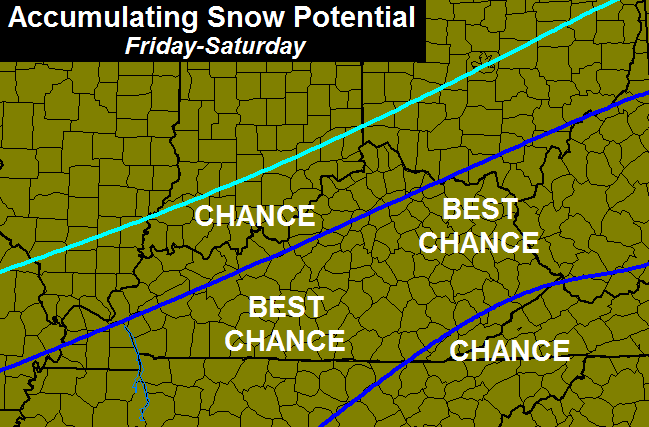
There are a lot of variables to work through before we can determine how much sticking snow we receive. Could be just a little or could be several inches. The later is where the NAM is…

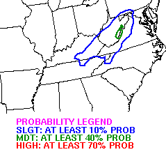
The folks at the WPC have placed much of eastern and southern Kentucky in a slight risk for a 4″+ snowfall by early Saturday…
Anytime I post maps, many people have the tendency to just look at the model maps and not read what I’m really saying about them. Please read. 🙂
I will have a much more in depth look at this potential on WKYT-TV starting at 4 and another update here later this evening. Enjoy the day and take care.

Is this going to affect social activities like basketball games this week and Monday chris?
Yep. As I stated before. …This thing need to jog SE about 50-75 miles or so. 🙂
The best thing is we don’t have to wait long, by this time tomorrow we will have a good idea if this thing is going to hit us and how much if any snow.
Thanks Chris sounds like some may have a shot of at least seeing some snow. I say bring it. But I am still cautiously optimistic.
Nice to see it is still on the maps south of Louisville. Give it time and the river counties should be sitting pretty. Wish it was 10 degrees colder though.
Can’t help but notice the word “storm” removed from the wording……. Just sayin’.
Just remember, its been 50 to 60 degree`s lately. The ground is very warm and it would take a few hours of snow for it to start sticking. The models arent taking that into account, although I`d love to see 4 to 6 inches here. Then add another 2 or 3 from the clipper system. I just love snow
Will us poor snow deprived people in Adair County see any of this? My kids are desperate for a good fun snow to play in!
Banking on this to get my outlook of two 2″ – 3″ events half way there 🙂
Winning!
You have gotten one already?
Will be if this happens 🙂 Half way there!
Gotcha
You all can love snow all you want.I don’t like it.period.
Well this winter must be making you very warm and fuzzy 😉
The sun does because I can be out and be active in it.I can’t do that in the snow.
sure you can you just have to be a little uncomfortable.
Your familiar with the 4 seasons?
Sure, Frankie Valli was the singer 🙂
Working my way back to you babe’ perfect song for the coming winter weather
If its winter weather.
Dress for the environment and you’ll be fine just like millions of other people who go out in the cold and work and be active every day.
Imagine if I had said those exact same words. 😛
Temps starting to raise a red flag..Hopefully the Euro keeps trending colder..Shame we can’t get some decent blocking and a Negative NAO to slow these systems down..
Im telling you guys with this upcoming system temps will be marginal I wouldn’t get to excited. The clipper system for the later half of the weekend is looking less and less promising.
it’s a sad winter
when you cannot even count on a clipper coming through at least a few times.
Sorry can’t help it….its not going to happen in cky…probably 1/2 inch…but hey that’s more than we’ve had all year in richmond!
…a 1/2 inch more than we have had so far…
Into the 50s in almost all of kentucky today. Temps have been 5 or more degrees warmer then models have called for. A few degrees will mean a big difference in this setup.
Temps have max out for today remaining steady and slowly falling as the day wears on
It was 52 here at two 54 for now 4
Models start their usual backtrack in 3, 2, 1…… Wait, that would be tomorrows post! 😉
If this does end up being anything at all, but yet falls dramatically short of final call, you’ll need to make room for a fourth goat over there.
If that happens, this place is going to get U-G-L-Y and you know it. It will be even worse than around this time last year because almost everyone is going through no snow. Though, in fairness, they haven’t had to deal with all the misses (which is the worst part).
I see great potential for a population swap here.
http://i.imgur.com/temWcvr.png
Well at this point, looks like the entire state could get a taste of snow. Let’s hope for the best.
umm no
By saying “please read my comments instead of just looking at the maps” Chris is leaving a lot of room to be able to backtrack as the models are surely gonna change over the next 24. I see it warming up as the “storm” goes through and then getting cold just in time for it to dry out again
That is not actually true about Chris. He has been falsely accused of “hype” every time he mentions the potential of a decent snow around here.
I don’t think that was his purpose.
I am always skeptical of any model. I am less skeptical of forecasts. I think CB just wants everyone to know models and forecasts aren’t the same.
Not saying hes “hyping” anything, but he is the most “optimistic” about snowfall and winter weather…..
Thanks Chris for letting us know that there is a CHANCE for some snow. I would rather hear that there is a possibility. “I dwell in possibilities.”
Problem is it’s like when I buy a PowerBall ticket. I know there’s a chance. But I know better than to quit my job.
Temperatures will not be our friend with this system. No artic air to play with, only a little dynamic cooling and being very warm the last few days. Even if it does snow hard enough to stick, it will be melted by Saturday afternoon.
The clipper for Sunday is going to bring rain here, if anything. Too far north.
Chris just said it’s not gonna be a storm. Looks like temps on Saturday go above freezing for almost everybody…..hate to say it but even if there a little bit to see Friday night, overall its “NOTHING TO SEE HERE”.
Sadly this.
Andy Griffith agrees.
do not cancel your date with Thelma lou.
90 percent of our snows melt the next day, that is nothing new. But a few hours sat morning for the kids to enjoy a few inches of snow will thrill them just fine.
Nws in Jackson forecasting 1-3 in there area.
Need a few more model runs here for a little better confidence. 2-3 inches in the Lexington area would be nice and at least a start. Hopefully things will ramp up from here.