Good afternoon, folks. It continues to be all eyes on a developing storm system across the deep south. This storm dumped more snow in Amarillo, Texas in a few hours than what New York City and Boston have had the entire winter. Think about that one for a minute.
This same system will work across the deep south and then up the east coast by Saturday. That will impact our weather with rain and a mix developing from southwest to northeast on Friday. As the air cools, a period of wet snow will develop Friday evening into Saturday morning.
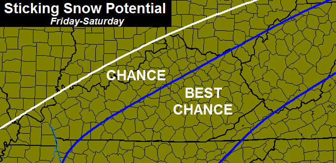
I have no changes on the areas with the best chance of seeing some sticking snow…
With temps close to 32 degrees, we would need some heavier bursts of precipitation to develop if we want some snow on the ground. The GFS develops one of those bands right on top of central Kentucky…

That also shows the super duper sharp cutoff with this system on the western side.
I will try to get a first call map out later today, but the banding features will make it hard to pinpoint exact amounts. I’ve seen a lot of folks throwing out numbers on my twitter feed over the past few days. Too many variables for me to be doing that. Regardless, I will get the blame for those forecasts, anyway. 😉
Enjoy the afternoon and take care.

I’m in Ripley, OH – near Marysville. Oh so close for me! Love your blog BTW!
I’m not blaming ya chris.lol I just don’t like snow is all.myself I like to be out and about.I can’t stand being cooped up in the house.
Goodness. Be out and about then! There is nothing holding you back. It can be just as beautiful outdoors this time of year as any other. If I forced myself to stay cooped up during winter, I sure would hate it too.
Geez, if he doesn’t like going out in the cold, he doesn’t like going out in the cold. Lots of people including myself a) don’t like having layers upon layers of clothes and b) just HATE being cold in general. He doesn’t like snow. You like snow. No reason to jump all over him.
If he doesn’t like snow then this is the perfect place for him. 😉
You should really try to get out and enjoy the snow if and when it comes. It’ll do you some good it’ll put some hair on your chest. Yeah buddy!!!
Not jumping. Just suggesting.
im gonna try and be optimistic and say I predict nothing to 8″ for everyone ..im pretty confident in that 🙂
im gonna try and be optimistic and say I predict nothing to 8″ for everyone ..im pretty confident in that 🙂
Just saying on this new gfs,, i have yet to see anything out of the sky when it shows this big area of the color gray ( light gray, medium gray, dark gray). So when i see that color it tells me nothing is going to happen, not even .0001.
When I see a dotted blue across the area, I think it means a little spoon of blue Soup for some..
Completely understandable perspective from a Bengal’s fan 😉
Just stick with a general precipitation forecast of rain to blizzard conditions, depending on where in North America you are. Temps vary from hot to not. There, that’s a good forecast that shouldn’t catch to many naysayers.
*too
Thanks Chris. I trust your calls over anyone else. Whatever we get or don’t get, that is the way it is! Thanks for the update. Have a great Thursday afternoon everyone!
No sticking snow Friday, none with the Sunday clipper going north of here and arctic cold returning (with the dry air that comes with it). I`m giving up on snow this winter.
Thanks Chris.
Well, a little snow might get the ball rolling. Onward and upward!
Anyone notice the 12z canadian? Looks like it develops a second area of precipitation on Saturday for eastern ky. Interesting…
CB, I imagine it must be frustrating trying to start making specific snow forecasts, but if it gets too stressful just remember that it could be worse and you could be Gerry Hamilton (ESPN).
Object lesson in how NOT to ‘multi-task’. 😉
Well, the anticipation of something, anything is exciting regardless of the outcome. Of course a follow through is always nice.
I would just predict a trace to 12 inches for KY and you’ll be covered fine with this system.
cant be wrong with that except if u get less than a trace …nothing
You don’t have to tune in via television or log in either. Tomorrow if it starts out as rain, it’s raining. If there is some snow flakes with the rain, it’s a wintry mix. If you see snowflakes only tomorrow, it is snowing. I don’t know of any meteorologist that has a more sound forecast than that. No college, just 12 years of high school. I know throw me under the bus, I have broad shoulders and can carry you!!
u mad bro ?
12 yrs of high school?
12 years of high school huh?
I know right hahaha!
You don’t have to tune in via television or log in either. Tomorrow if it starts out as rain, it’s raining. If there is some snow flakes with the rain, it’s a wintry mix. If you see snowflakes only tomorrow, it is snowing. I don’t know of any meteorologist that has a more sound forecast than that. No college, just 12 years of high school. I know throw me under the bus, I have broad shoulders and can carry you!!
Jerry, I can tell you have no college education cause what you just said is blah blah blah and a bunch of hipity hoop la!!! Gibberish
Really?
How so ? Basically what he said you don’t’ have to turn to a blog or website or television to know whats going on with the weather tomorrow Just look outside.
Seemed fairly irrefutable fact to me and I went to college! Just like Plankton from Spongebob 🙂
Jerry speaks the truuuuttthhhh! 🙂
hes right except hes on the blog so y did he come here lol
Like our weather- irony! 🙂
I take it as trolling to me Jerry seem to be degrading. I could be wrong but that’s my point of view.
I would say u r correct
Just bring northern my close to the Ohio river some dying for some pretty snow so I can draw a sketching
December and January….summed up by a song by Green Day: “Wake Me Up, When September Ends”.
This is killing the snow lover in me.
I also feel for the guys who depend on some form (any form) of winter weather to collect a paycheck.
I totally agree. Snow is a bonus check for me
Rodger is bemoaning this sad winter. Who knew November would be his coldest and snowiest month? Unbelievable!
Yup.
Big difference for some parts of southern and Eastern KY on the GFS latest run..We be in the blue..
I would be blissfully happy with NO SNOW!! and I mean BLISSFULLY HAPPY!
Then you outta be blissfully ecstaticly happy