Good evening, gang. I don’t have many new thoughts to add to what I already have out there. Temps will continue to drop tonight and we will see a rapid drop occur from northwest to southeast late tonight. That means temps will drop deep into the 20s and set us up for icy roads.
The Hi-Res NAM sunrise temps…
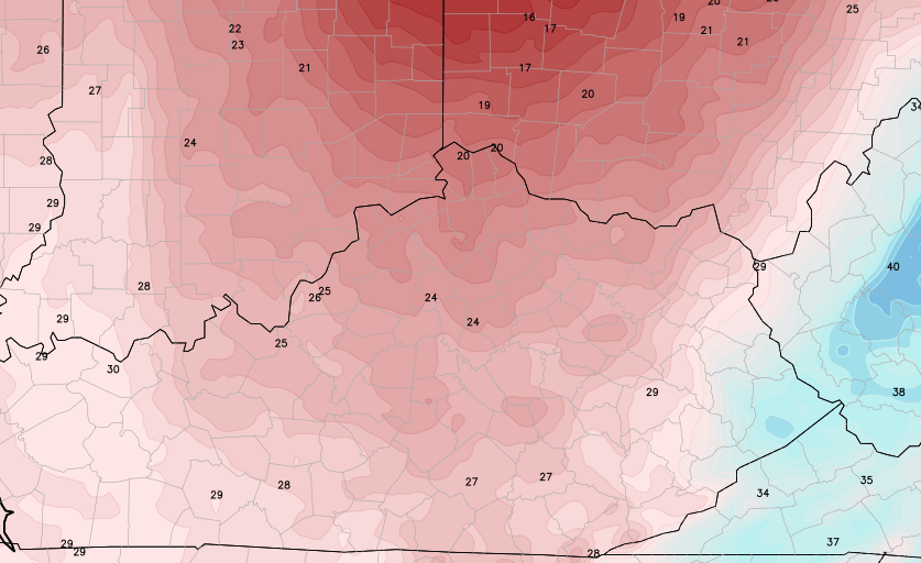
The rain will change to a period of light snow across central and eastern Kentucky and we could pick up on some light accumulations. The snow won’t be the big issue. I’m more concerned about a quick freeze up that could lead to some icy travel conditions on untreated roads. We have a lot of water and slush still out there and that will turn to ice in a hurry as temps drop.
I got a tweet tonight that I have to share with you guys. I think this is the look we all have when the word snow is mentioned…
@Kentuckyweather This sweet guy is hoping for a chance at another snow day! pic.twitter.com/n3uX6jnS0r
— Marlena Renee (@marley12187) January 26, 2015
I think we’ve found the blog mascot! 😉
I leave you with the tracking tools…


Enjoy the rest of your evening and take care.

It is hard listening to the rain and watching the little bit of leftover snow melt away. One day of snow doesn’t really cut it. I wish I was up north this evening.
I am more a fan of the 8″ to 10″ manageable snows 🙂 The much bigger snows are ‘stranders’ unless you have a snow plow. I also like having power 🙂
They can keep getting these instead of us IMO 🙂
Perhaps my frame of mind would be different without a big and sloped driveway, plus power that goes out always with big weather…… Yep, it might.
🙂 🙂 🙂 🙂 🙂 🙂 🙂 🙂 🙂 🙂 🙂 🙂 🙂 🙂 🙂 🙂
Love the blog mascot. Clippers used to bring snow to our part of the world, now most of them bring rain. Also it seems anymore that every storm has to start out as rain. I remember several years ago when we would get a storm in Winter and it would start as snow and stay that way. It is extremely rare for that to happen anymore.
dog days of winter.
Love the mascot…how I look. Not looking that way much so far. Could Somerset get enough for a snow day, we are feeling really left out down here.
Ha ha! Perfect blog winter mascot for sure Chris. He’s got that deer in the headlights look! We currently have rain and our temp has dropped from 56 to 43 since about 7:10. Cooling down quickly. Maybe ce get a little bit here in Somerset. And BJenks is right, our snow always started as snow and stayed that way in the past. Now, we can’t even get snow. Oh well. Have a good Sunday night everyone. Thanks for the update Chris.
Sorry, Jimbo. Credited that to the wrong person.
The look on (mascot) Sinatra’s face is priceless!
Thrilled with the snow we got here in Fayette County. My grandson created his very first snowmen, 4 in fact! I believe we’ll all be grateful for what we did/didn’t get as we watch the East Coast in the coming days. I am, however, still wishing for a snow day from work. It could still happen, there’s lots of winter left – – on the calendar anyway!
Crazy amount that is forecast for New York City and Boston! The National Weather Service has a MINIMUM forecast of 24″ or 2 FEET, and could potentially accumulate up to 36″ or 3 FEET!!! For reference, NYC biggest snowfall event was 26.9″ on February 11-12, 2006. Forecast from NWS: 24-36″
Boston, MA biggest snowfall event was 27.6 on February 17-18, 2003. Forecast from NWS: 24-36″
So according to the NWS forecast, it is very likely that this will top the records. I know this is OPS, but I mean c’mon, if this pans out, it will be historic and talked about for many, many years to come. Especially since it would hit the most populated city in the US with over 8 million residents.
O P S, yeah in distress
O P S, yeah a mess!
I little play on another song that had a three letter acronym 🙂 😉
Just dropped the mic.
dry slot will kill it and Boston had the same similar storm in 2012
It seems the models always over do the amount of moisture that will be available after the temperature crashes. Radar appears to show there want be much to create snow in Lex after midnight.
And glad I’m not headed to Philly THIS week.
Had a 4.0 inche snow in November, got 4.5 Friday nite, so its ok in my world it has not Been snowless!
Trust me I’ve seen worst totals this time of year before 🙂
Stay positive foks llong way to go yet?
Sinatra is proud to be Kentucky Weather Center’s blog mascot! Thanks for the honorable mention!
Maybe Sinatra is what we need to finally break this pattern!