Good Monday afternoon, guys and gals. The day started with snow in many areas and another round of snow is on the way tonight and early Tuesday. This is part of a very wintry week of weather that features another clipper and the potential for a bigger storm for the weekend.
The system coming in tonight should be able to put down some light accumulations for many. Here’s a look at the odds of seeing a light snowfall where you live…

This is likely to cause another round of school delays and cancellations… but time, centered father west than where we had them this morning.
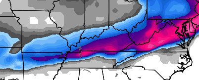
The next clipper looks to arrive a little quicker on Thursday. It may get in here in time to start as a period of freezing rain in the north and east. That would change to rain by the afternoon and evening and then over to light snow Thursday night and Friday morning.
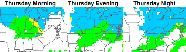
The timing on that will likely cause some travel issues by Friday morning as very cold air pours in along with the light snow.
I continue to watch the weekend potential and so should you. A developing storm system is going to try to roll eastward across the lower Tennessee Valley from late Saturday through Super Bowl Sunday. The Canadian Model…
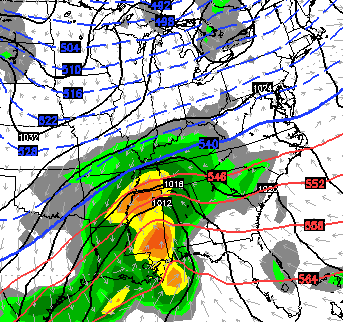
 That would put a smile on some snow loving faces. Again… it’s important to NOT just look at one model or one single model run at this point. The models, especially the GFS, will continue to jump around with whatever storm system forms out of all this.
That said… the setup is certainly there for a sizeable storm system to POSSIBLY impact our region.
Another update later today. I leave you with some tracking goodies…


Enjoy your afternoon and take care.

Would be a dream come true for the SE KY, aka the Snow Dome
Its time to break out the micrometer to measure the snow. 🙂
You sure there’s enough even for a micrometer?
Just getting prepared 😉
C’mon weekend storm, if your totals hold out, us in West KY can actually have their first snowfall of the season…
Whatever the case, no talk about big ice is a big win 🙂
and yes, I understand its a model but at least it gives us hope
Should be a good test for the crappy GFS concerning the Blizzard in the NE..Euro and Nam showing tons of snow while the crazy uncle GFS showing not near as much..Also looked like the Canadian was not showing as much for the NE too..
Fly me to the moon i want to play among the stars
Thanks Chris! The weekend storm, whether it materializes or not, is very nice eye candy! Temp is down to 27 here in Somerset. Cold Monday, for sure! Have a great afternoon all, and stay warm!
Whatever comes this weekend, will be rain especially coming from southwest. In western WV and Eastern KY we only get snow from one storm track. That is from the Florida panhandle to VA beach. Like superstorm 1993. Otherwise they all start as rain and end as flurries.
Uhhh…..that map IS a low coming from the South lol. Which if it verifies is strong enough to pull cold air down from the North. Hence, the frozen precipitation which we call….SNOW.
I hope it is snow. But look closely at the map, the center of the storm is to the southwest. When they come from the southwest or northwest they turn the wind from the southwest or southeast which means cold rain. But again I hope it is snow but I am not holding breath considering our track record.
I noticed on the latest drought monitor that moderate drought is really expanding across western KY. We need some active weather to keep it from spreading further eastward.
http://droughtmonitor.unl.edu/Home/StateDroughtMonitor.aspx?KY
western ky gets it and E/S/SE KY notta.lollllllllllllllll weekend storm looks grrreat right now, oh wait minute the WAA will take over as well as the N/NW turn.
but the weather is going drastic with the blizzard now and big storm on its heel for weekend. u never know….
Temps dropped so fast here! Ice is already forming.
Checked out your site. Nice. Good to see you back.
Followed your blog quite a bit last yr but haven’t seen u blogging much at all this Ryan. Which I can understand with the se lack of winter weather. Lol
I approach the weekend storm as like the gla&ss is half empty.
will not really know until Friday.
three quarters of the gla$ss is now empty as I write about this subject.
Snowing here at union co ground begin to get cover.
Ain’t no party like a blizzard party! Woo hoo!
I don’t need no stinkin’ blizzards! 🙂
Only blizzards around here is at dq
Is the snow on radar the on;y snow coming through today or is there still a little coming in early Tuesday?
Doesn’t look like much to me.
Same Question? ? If so, wky is the only people getting any “little snow”…richmond was in the edge of likely..but ut just like we r just on the edge of NO SNOW
Below is from the forecast discussion on noaa.gov for Lexington are. We shall see?
However, we should
mention that the overall synoptic setup for the this period fits the
conceptual model for significant wintry precipitation for the Ohio
Valley. This will be something to watch closely over the coming
week…stay tuned!