Good evening, guys and gals. We’re inching closer and closer to Super Bowl Weekend and it’s looking more and more like a round of winter weather will roll in. How much of an impact remains to be seen, but the potential is there for a nice smack from Old Man Winter.
If you read my last post, I dissected what was likely wrong with the GFS. I won’t rehash it all here, but the new run basically corrected itself in the exact manner I said it would…
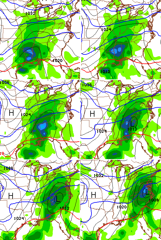
As of now, a system with that track and intensity makes more meteorological sense to me given the look of the pattern. Here’s the snowfall map from that run…
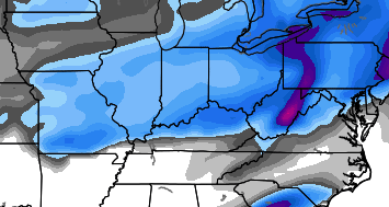 Notice how that matches up VERY well with the snowfall look from the European Ensembles…
 It’s always good to see some matching models, but that certainly does not mean they are correct. Keep that in mind. 😉
Earlier I broke down the bias of the GFS and now I’m going to do the same for the European Model. It has a tendency to overdevelop storm systems and that looks like what it’s doing on it’s last run…
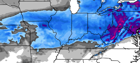 That still produces a lot of winter weather around here, but I don’t think the storm wraps up that much, right now.
If you have travel plans across our region from Saturday night through early Monday, please keep checking back for updates to see how this system plays out.
I will have a full update later tonight. Take care.

thanks Chris
I love your expertise.
u know ..I don’t live in SKY but im starting to really feel for u guys ….the fence lives…32/33 lives..every other cliché lives for that area
That puts a solid 1/2 inch down in Somerset…….boo yah
LOL!
http://m.youtube.com/watch?v=hZwVvwp8i-M
Timing of this mess? And, how much are those maps showing for Lex-metro?
Cool, we basically stay at 0 inches for the winter.
Good luck to the people in the upper 1/2 of the state. I really wouldn’t want to be sitting in the spot the models are predicting for snow right now, but at least you are still in play. History says this thing moves to the north before it gets here, so unless you are in far NKY chances are you see a lot more rain than snow.
Still sitting at less than one inch for the winter in Knox Co. Bring Spring.
I live near Cincinnati. Last week, Bardstown got five inches and we got none. Hopefully now it’s our turn 🙂
Unless you live in Southern KY then we just have to worry about how much rain. 😉
Get some new material.
It will be ok Jeffy
Okay….
I tell ya’ I don’t get any respect! 🙂
I’ve got a million of em’ where that came from! 😉
no respect…. Rodney Dangerfield = models 🙂
and the snow dome for SE KY, continues…
Going on for two years now. Most of the state had pretty good snow totals last year and SE KY probably didn’t total 5 inches.
Rodger will take the GFS for $500, Alex! That would be pleasant in Rodger’s backyard!
Nothing except heavy rain for Somerset then flurries behind the system I’m ready for spring now!!!
I told u all winter is over, normal temps in upper 20 low 30s with a clipper or 2 at best.
I think you may be right rolo. Not even had a promising miss here in SEKY.
No rolo you did not.
Yes he did
I think you meant significant snow is over, since 20s and 30s with a few clippers suggests winter is still here 🙂
Even I’m is not throwing in the towel….. Well, I might swing it around a little, but not letting go.
Hello Chris! I used to follow you in your WSAZ days, and still check in for forecasts since your maps still cover us. I have a small request. Could you include the legends for the maps? I see colors, but I don’t know what they mean exactly. I can page back through, but it would be cool if every map had that info. Thanks for keeping us so well informed!
If I remember the legend right on the snow maps, the gray is 0-2″, the blue is 2-5″, dark purple around 6-8″, and the pink is 8″ plus. I think that’s pretty close if they’re Maue’s maps.
18z GFS puts SE KY back in play for the storm, but mom the less, we ALL know that’s not going to happen. lol No way, no how.
nonetheless that is…
Chris, First, I appreciate all your time. Second, I remember back in the 70s, when I was a boy, that we got big snows, at least it seems we did in the SE Kentucky area. How did they happen? I would appreciate your insight into the “anatomy of a big snow” for South East Kentucky. As to how they happened in the past, and what conditions are necessary for one to happen in the future. Thanks.
Honestly, I’ve asked this several times, and I got a few answers, but I didn’t really understand them.
I think the strong COLD high pressure needs to be in northern Michigan or in that general area with a strong low moving just east of the apps which puts KY in the deformation zone and that strong high keeps the low from going through KY.
The low pressure needs to be probably in northern Georgia and move just off the coast of Virginia. That would give southeast Kentucky a good snow. The problem is that most of the lows have been moving into Kentucky and that is why it gets too warm.
Yes the high pressure center needs to sit directly over Michigan.
Not northwest Michigan, not the UP of Michigan, right smack dab in the middle of it. BC, back in the day, would allude to this–I still remember watching him and when we got big snows, he’d allude to the high over lower Michigan.
Looks like another north of I-64 storm to me. Meh.
Yep. The trend will show over the next few days if it does the usual thang.
Might I remind you all this storm is 4000 miles away.
And not even a storm yet, since the ingredients are not in place.
Little or no accumulation for southern Ky. It’s the only winter forcast Bell county gets. True that.
…and SE KY gets the shaft again. Blah
At this rate, I will be pleased with anything more than a dusting here in Knott! Crossing my fingers for snow!
Yet another look from the GFS..Low was moving into the Carolina’s on the 18z run and now moving through Ky on the 00z run..Looks like a phase to me..Hopefully someone will get some ICE instead of a cold rain..
That is pure goofy. Why wish ice over cold rain? One causes a lot of accidents (far worse than rain or snow) and power outages and the other mainly washes stuff down- including the nasty salt still lingering.