Good evening, friends and neighbors. It’s all eyes on the weekend system and how we are seeing a similar trend developing among the models. Before that, we can’t short change the clipper moving in here on Thursday.
That system will provide a quick spike in temps ahead of it and a bigger crash behind it. Gusty winds of 30mph to 40mph will also be possible. Rain showers will then change to snow showers Thursday evening into Thursday night. I’m also seeing a bit more of an upslope component taking shape on Friday. That simply means our northwesterly wind will try to squeeze out some pretty good snow showers across central and eastern Kentucky.
Slick roads are a possibility on Friday. Winds will continue to be gusty as temps drop during the day. Single digit wind chills are possible.
With this clipper tending deeper, that is likely to impact the storm system coming. How so? It could very well force this system to scoot eastward across the Tennessee Valley. That seems to be a growing trend with the latest computer models. Here’s the European Model…
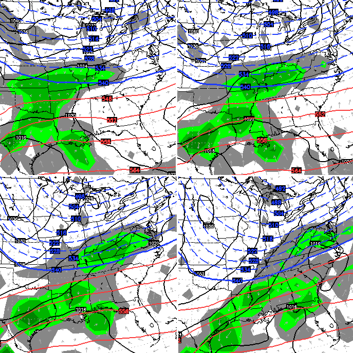
That’s a solution the models were showing a few days ago and the one that makes the most meteorological sense, right now. That kind of track would try to put down some snow across the state…
The new GFS is similar with a general 2″-4″…
I will keep telling you to not get caught up on model snowfall forecasts because they will change with each run. I keep focusing on the overall trends and the setup and so should you. 🙂
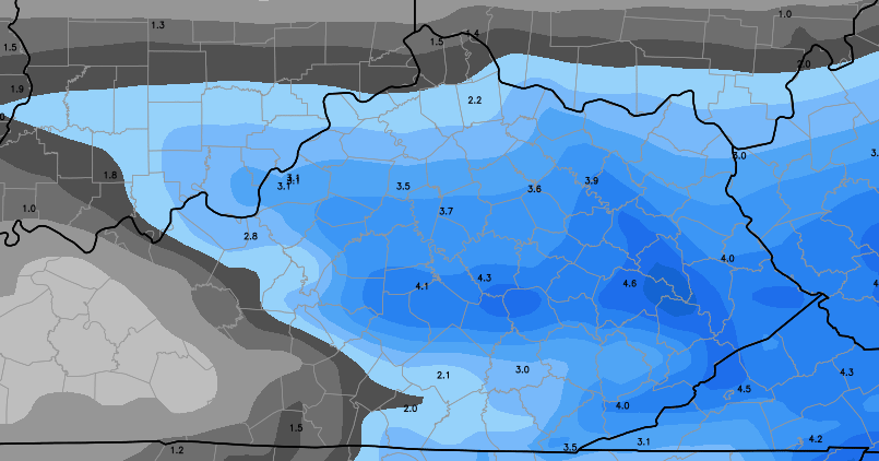
That would unleash some very cold air behind it for Monday. The same model run (and the actual pattern) suggests additional systems trying to scoot across the Tennessee Valley next week. For fun, here’s the total snowfall through next week to prove the point…

That’s all I have for you crazy kids. I will update things later tonight. Enjoy the evening and take care.

Chris you’re a calm voice in a world model insanity.
I absolutely love the days leading up to a possible wintry system. Yes, I’m bummed when it sometimes doesn’t pan out but half the fun is in the tracking! Always look forward to the next post from CB with the latest updates on the models. It’s my morning wake-up ritual! 🙂 Surely I’m not the only one that feels like it’s Christmas morning waking up to Chris’s overnight full update…who else is with me??
You nailed it Teach! I really enjoy the anticipation, the tracking and the thoughtful discussions. And I sure do love a good snow.
“sometimes”? Now THAT is being optimistic! 🙂
The cup isn’t just half full here, but running over and in need of some serious sipping to avoid spillage 🙂
When Chris starts posting multiple times during the day it perks my interest. I’ll still wait till Sunday to look out the window before my inner kid gets excited.
Haha. Yes. My inner kid agrees.
PLEASE SEND PAINTSVILLE KY AROUND A FOOT!! We’re running out of winter and I would love to have at least a foot and maybe even 2 by the time old man winter is gone
I always wait up and check it before I go to bed.
First page I read in the morning
Anticipation…..ah yes! Let’s see some snow, especially for those of you who have been deprived. Bring it on!
Ya’ll a bunch of weather freaks. 🙂
I’m a proud one myself. haha
One of the standouts is Rolo!
Goatrider in the sky
I’ll be curious to see. I mean the system last week was supposed to start out as rain and switch to snow late evening and instead for us in Central Kentucky started out as snow at around 2 pm and gave us several more inches than originally forecast (5 more than good old “he who shall not be named” was still forecasting at 10 pm that night :P). Yesterday’s weather had today’s highs listed in the mid 40’s… it started out at 19 degrees and got into the 30’s for only about 3 hours. I’ll be interested to see if it gets anywhere near 45 tomorrow. Seems like we’re consistently seeing lower than forecast temps this season.
I found a great article on mpr (Minnesota public radio) talking about how mets should deliver the message of uncertain-ty to the public on forecasts so that the mets don’t lose their credibility people could understand why it’s like that. Its based off the bust in NYC. It’s a great read and I think all you should read it! Here
Finally I was able to post this! Hey y’all, I found out that the autobot rejects a comment with the word “u-n-c-e-r-t-a-i-n-t-y” A new word we can add to the dictionary of “bad” words like Bluegra-ss, Gra-ss
I also fount out it disapproves the “t-a-i-n-t” part of the word.
Tahee
Geeessshhh
Talk about a roller coaster ride this week is turning into for the weekend system! This feels like worse than usual flip flopping for some reason.
did someone say upslope? that’s music to my ears
hey bubba u mentioned that’s y chris moved this way bc he was a snow lover….we had some doozies while he was around …since he left ..superstorm sandy dropped 2 ft here ..last year had a 19 incher which started out forecasted locally 1-3 inches the day b4….actually heard a Met apologize on air over that one….that’s about it for big snows the last 2-3 years…..maybe if he came back he would bring the snow mojo with him 🙂
Folks south of the river from Lexington on down have hit the 17 year mark without double digit snows. Most of Lexington as well. Go north of 64 and they have had a few bust 10″.
Even our few 6″ inch events have been sparing. Dry snows that would drift in spots and look bigger than they were.
we have only had 12″ this year …and 6 of that was a few weeks ago …usually here is between 50-70 from oct to april …so we r feeling the drought this year
While we wait on the snow storm, I have a question.
Did Duke win tonight? Click my name to fine out!
BBN
the luck of the Irish
Yes it’s like Christmas, lots of anticipation. And for the womenfolk on here like me, maybe you’ll understand this…when Chris starts talking probability instead of potential, I get all nest-y inside and get this bizarre desire to bake things and freeze them and to make sure I have chili and canned goods and other things on hand that will cook up nicely on a camp stove. I clean a little more and make sure the extra blankets are fresh. It’s a little like the Martha Stewart version of doomsday prepping and no doubt brought on by post-1993 PTSD after waking up to below zero temps and no power for a week.
At least with Christmas you know there’s a pretty good chance your going to get something. 🙂
Hopefully this thing keeps trending our way. Meteorological winter only has about 4 weeks left. Can’t afford too many misses with the time frame going into the last 1/3 of winter.
Another great post. I am liking all the contextual break downs recently.
Let me second that recognition. One of the weak spots here has traditionally been approaching the topic from an educational slant, and it’s treat to see the models being discussed in that way. Keep it coming, I say.
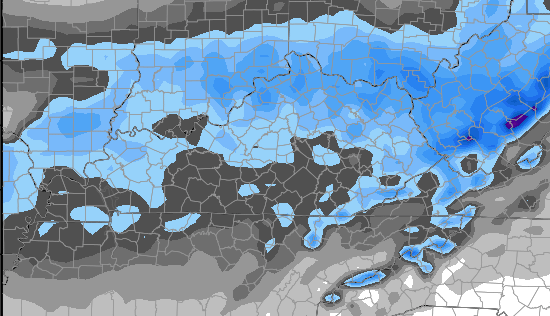
https://kyweathercenter.com/wp-content/uploads/2015/01/Euro-Snow4.png
Forgive my Golden Triangle upbringing and laziness for neither knowing the county by sight or by looking it up to properly name it, but
what in the world did that one poor county in extreme WKY do to get left out like that?
Must be Andy Rose’s county.
🙂
Ah, Fulton and Hickman counties.
0z GFS give central ky a serious possible winter storm threat this weekend.
Map please
6-8 for Lexington it looked like Vinny. 4-6 for Louisville.
Thanks Go Cards! Oh wait, I see what you did there…. You made UK fan type Go Cards… Crap, AGAIN!
BBN
Well, I wasn’t trying to do that. I’ll be a tiger fan tomorrow. Go Mizzou!
derekp and Go Cards are right. 00z GFS has a decent hit for much of KY.
Don’t count your chickens before they hatch I remember one year when I was pregnant with my daughter 26 years ago on March 31 Couny had 6 inches of snow so don’t count when her out too soon since we haven’t had a lot of snow this year we could just get surprisedThe weather has just really begun for us bring it on I want to build a snowman LOL⛄️⛄️
Campbell county….