Good Thursday and welcome to a very active day of weather. We have a potent system dropping in from the northwest and this cause some wild swings out there. All of this continues to be part of a very active winter period and it’s about to kick it up a notch. Super Bowl Sunday continues to look very, very interesting. More on that in a bit.
First things first and that’s the clipper system diving across the Ohio Valley today. I’ve pretty much covered all the basics of this for several days now, but here’s a breakdown of what to expect.
– The day may start with a band of showers across central and northern Kentucky. The ground is frozen, so watch for the potential for some icy spots… especially in the north.
– Temps will quickly rise toward 50 by late morning and early afternoon as winds crank to 35mph to 40mph at times.
– The front swings through and our temps drop quickly from northwest to southeast. Readings will drop through the 30s this evening with some rain and snow showers.
– A better shot of snow showers and flurries will be with us overnight into early Friday. That could cause some minor accumulations across the central and east.
– Friday’s a very cold day with temps mainly in the 20s and wind chills in the teens.
Ok, let’s get to what you are all waiting for… the potential for snow on Super Bowl Sunday. We are still outside of my 48 hour window of when I expect the models to lock on to one solution. The GFS still hasn’t spit out the same solution twice, but it’s latest run has snow lovers going crazy…
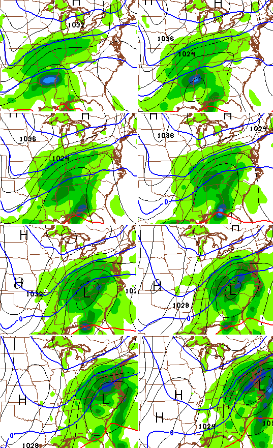
The European Model isn’t as snowy as the GFS, but it is still showing a similar look…
 That run is very close to becoming a bigger event on a similar scale to what the GFS is showing.
I’m going to say the exact same thing I’ve said for days now (stop me if you’ve heard this one before), don’t get too caught up one run of any one model. Obviously, if the above solutions work out, we would have a healthy snowstorm around here. Again… temper your emotions for a bit longer until we can get a little more consistency in the model runs.
If we can put snow on the ground this weekend, temps by Monday and Tuesday could drop toward single digits or even below zero.
Another snow maker will try to develop by the middle of next week with another one trying to pop a few days later. Each will have the potential to tap additional arctic temps.
I will have updates later today. Take care.

The GFS and I would be friends for life if this becomes true. Here`s hoping for this to be on track. I`d take 6 to 8 inches here in Shep.
I agree! Looks pretty sweet for Frankfort and Lexington areas too.
Looks like we might get winter all at once here. I can handle it.
No one – I repeat – NO ONE get excited. It’s still Thursday…..
As I was reading this I kept thinking, I like waffles. Those models are going to waffle around then shoot north and we end up with nothing. Nothing to see here folks.
You’re wrong this time. 🙂
I’m sticking to my guns. February is a monster for winter weather lovers.
Definitely possible. The trend is your friend. BUT, there has to be a trend buster someday, right?
THE SNOW IS COMING! THE SNOW IS COMING!
Sorry I could not help myself.
Ruh roh! Somebody already went for the kick 😉
This
“While we’re young?”
Still not on the board with these models. Going to give it until Saturday like Chris says.
Thanks CB for the update.
This is more like it 🙂
I haven’t been on board all winter (besides the one good snow in November).
I think this is #2 Winter Alert Mode come Sunday.
Fools gold, the gfs has been awful so why trust it now
Yep. When shows good stuff it rocks, when it does not it plays poorly timed polka.
Nailed the new york flop
Boston snow time lapse
http://www.youtube.com/watch?v=KlULhnUq8hU
Very cool. Music is a nice touch too….
Reminds me of our Dusting of 1998. Fearless Frank Faulkner on the morning of it was on WKQQ and said the infamous line that got pegged on all mets 😉
Just a dusting.. Just a dusting…..
I wonder if channel 18 has any archives of Brian Collins in complete denial the night before that we would get nothing more than a dusting?
When it was already snowing heavily. Still liked BC- he rocked real hard!
sometime Friday the low will be north of El Paso finally on land.
and if the euro and GFs is still spitting out these amount of snow accumulations.
it will be time to go out by your bourbon, Bread, and milk.
Buy a shovel or rent a snowblower.
hell with the Superbowl let’s go play in the snow.
I just remembered, we don’t even have a shovel. Ours broke last winter and we are moving in 6 weeks. hmmm…..to buy or not to buy.
make sure you order one that has A
curvature for your back
I bought one at Sears 3 to 4 years ago
what a difference that makes
Once again not much love for the south
Looks like the south is in it too- as far as map talk.
If you cut those totals in half as per the norm and that’s what you get. 1 inch does not equal in it. 😉
Yes, Chris, I’m excited about the potential for snow on Sunday, but as a teacher, I have to take things one day at a time. I’m focused on a potential snow day TOMORROW!!! I’ll get excited about Sunday on Saturday (or midday tomorrow if I’m at home watching The View). Thanks for all you do.
I am with you!
“Temper your emotions…” Is CB kidding? Did he forget who he was talking to?? 🙂
However, a more southern solution to a few future model runs wouldn’t be a bad thing.
Someone said once that “you can’t please all the people all of the time, but you can please some of the people some of the time” with that being said I gotta hunch that the southern end of state won’t be pleased.
Remember the “storm” we were expecting a few year back. It was coming up from the southwest. Models got everyone excited but – nothing. The problem apparently was lack of weather balloons to actually sample the atmosphere as the “storm” hit land over Mexico. My point is – I am not going to really expect anything and certainly not get excited. Modeling, at least the way it is done now is way to imprecise. (Ask the mets in Manhatten.)
Saying that – Chris does a good job to differentiate his forecasts from the models.
We had a lot storms do that over the years, but point still on target. Yep, CB is in thought mode and not even threat mode, yet alone forecast mode.
Don’t look at the football! 😉
We don’t often get what we want but, I would like to see the whole state covered with some snow. That is a lot to ask for I know. Always ask for a lot, plead and justify, then cross your fingers and hope! Good luck to the whole state. The Irish beat the Devils so maybe we can hope for some of that Irish luck.
Cautiously optimistic, yet very skeptical and I absolutely will not buy into model map hype (especially the GFS) until we are 12 hours out. Even then i won’t completely believe until I see it.
Wise words 🙂
and conversely, if the models read all rain and nothing more, we would all be buying penny stocks by the truck load….beep, beep, beep…..back that truck up. 😉
Thanks Chris. The calm before the possible storm.
Looks good right now but understand a whole lot can change.
Great posts y’all.
Let’s hope the models don’t leave us feeling “deflated” ( I know, couldn’t resist) by Sunday.
People it is all going to work out for us this time! We have Sinatra the blog mascot as our good luck charm now. Tonight’s clipper is going to be an overachiever and the storm this weekend is going to be a bomb! Believe in the power of Sinatra!
Well. Everyone, cheer up a bit. The constant pessimissim is as bad as a brown winter. Anticipation is a joyful feeling, even if we all doubt the possibility of any real trend buster.
Roads being shut down left and right. Wrecks everywhere. It was in the mid 20s just a few hours ago and now it’s pouring rain= ice.
Waiting to NOWcast based on past history. Lucy can take her football and shove it. 😉
As expected. 06z GFS takes heaviest snow north. Waffles. I wouldn’t even look at model runs until the 12z runs come out Saturday. Then they will have an idea. So much fun tracking though
Fun, it’s like watching a bouncing ball…but I guess that could be fun…drives me nuts
Sure would b nice if the ball stops and lands in all of ky
Question is that in spite of the waffles, what is the overall trend of the waffles direction? Flat, north or south? Being rhetorical, but that is a key.
Seems a more north event to me, so the usual I64 favor.
Just came out of Jackson KY. Roads are horrible. Lots of wrecks. Becareful if you have to be out.
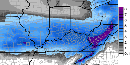
12z NAM says bam to the I-64 corridor that will change but if you like snow looking better and better
……. For the usual I64 corridor. Just like a Card fan- selfish! 😉
I might have just insulted you, based on the background in your picture. Sorry 🙂
Not insulted at all. Im a diehard fan and I insult the cards more than I should as of late.
Where did you see this? I just checked the WeatherBell site for the NAM and it didn’t go out far enough to capture the storm over the SDF to LEX corridor.
I’m still learning how to read these models, so let me see if I am getting this correct.
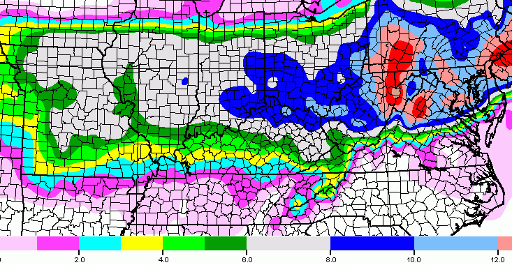
The GFS is calling for up to 10″ of snow in some parts of the state with a band running straight through the middle calling for about 8″.
The European, on the other hand, is at this moment only calling for up to 5″.
Please correct me if I am wrong.
Looks like very little snow for southern areas but that’s the norm. 1 inch or at best 2 for Bell doesn’t sound too great to me.
Well it seems the freezing rain eluded most mets this morning.
Higher elevations? No ice going to Lexington this morning.
No, not higher elevations but numerous counties across the east. FYI central Ky is not the only part of this state that’s inhabited.
I was raised in Paintsville, snap! I know about the east. It’s in my blooood.
Nobody said it was, Jason.
sunny and 49 in London right now – very nice day to be Jan 29th — wondering if SE KY will get anything Sunday night besides rain.
Nice day here in knott co. Sun peaking out and into the upper 40s. Nice to work outside in just a sweat shirt
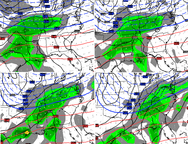
Canadian model did a about face and is wanting to join the snow bandwagon for the weekend.
come to my corner for this one Prelude…just do it. (NIKE)
One Louisville MET seems to think the rain/snow line will be a little more closer to their viewing area. Hope hes wrong.
That seems feasible for now all possibilities are still on the table. Im liking the trends towards colder and snow being the dominant precip type with the models. If we do big word there (IF) precipitation does predominantly falls as snow the snow should have some staying power. The next 24 to 36 hr model runs should be interesting to really see how this plays out.
location location location.
This
When does the next models come out?