4am Update
The new NAM just dropped the mic and walked off stage with its latest run. Check out these numbers…
No, I don’t sleep. 🙂
Previous Update Below
Good Sunday, everyone. This is a full blown WINTER STORM ALERT for the entire state of Kentucky from Sunday night through Monday night. A major snowstorm looks to slam the bluegrass state during this time and that may be followed up by record cold. Overall, this is a dangerous week of winter weather in our region.
Let’s get straight to the latest data before I throw out the First Call For Snowfall.
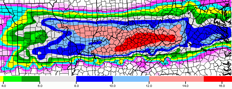
The European Model shows a shut down snowstorm…

While I am not totally sure of the algorithm used by weatherbell… I’m pretty sure that’s based on 10-1 snow ratios. Our ratios will likely be higher than that given the amount of cold present. Much of the snow will fall with temps in the teens.
The GFS also shows a major snowstorm and has been trending strongly toward the European…
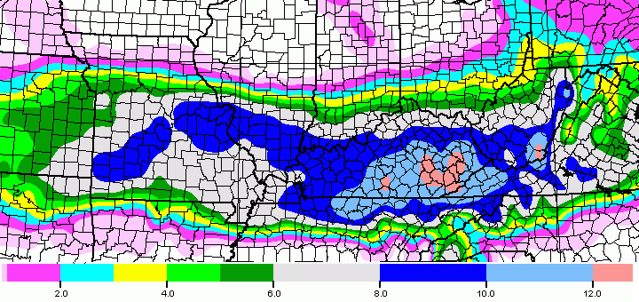
The NAM…

All three models show some areas picking up 12″ or more of snow.
For my first call map… I’m pretty much all in, but leave things general enough to be able to hone in on specific areas later today. Here ya go…
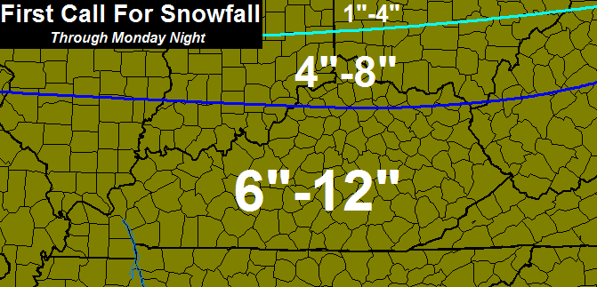
As you can see, I have much of the state in a general 6″-12″. That is the first call and I will fine tune the numbers and placement as the day goes on.
Something else I’m seeing more of during this event… wind. We could have some blowing and drifting going on with this as well Monday into Monday night.
Temps by Tuesday morning may reach zero in some cases. Another arctic front brings snow squalls in here on Wednesday and that unleashes record cold by Thursday morning…
Wind chills would be even lower!
Another snow maker is going to try to head our way by the start of next weekend. The next 10 days will likely become truly memorable across our region.
Updates will come later in the day. Take care.

Thanks for the update….here we go folks!
I’m ready.
Is it still too early to get excited?
unless its mid event its always to early IMO seen to many WSW and got less than 2 inches of snow.
Game on !!!!!!
“The next 10 days will likely become truly memorable across our region.”
I agree, it’s time for the NWS to start issuing more watches and warnings.
Charleston NWS still asleep at the wheel, no warnings.
Thanks so much Chris! Looks like an “old school” thumping.
You’re the best!
What an AMAZING post! I don’t think I’ve EVER felt so nervous in my entire life!! The last time I saw a potential storm like this was 1998 and it was also Feb! And that winter up until that point was awfully boring. It only takes ONE storm like this to make you so sick of snow. LOL
Paducah NWS still says 1-2 inches for us. I’m sure that will change significantly with their next update. CB has been on to this for over a week!
Been waiting on this weather scenario since March 1993 maybe not on that scale but close enough LETS GET IT ON.
Finally! Sitting in a great spot in here in Louisville. This looks to be a historic storm for the state with brutal cold and maybe even more snow for some later in the week. We’ve paid our dues watching the big ones go just north or even just south. Storms this size don’t come around often.
Holy crap. W. O. W. With this being February any snow that falls will melt quickly, RIGHT?
Well, the Feb, 98 storm’s snow didn’t melt quickly at all! And I don’t think the temps were nearly as cold as with this storm…..I think the small snows will vanish because of the sun, but if you have a thick snow pack, it’s a slower melting process, especially with temps like these…..
Doubt it…temps will likely be in the upper teens tomorrow and 20s rest of the week. Looks like it’ll be here for a while.
I hope this storm buries Kentucky! It’s high time that people be reminded that we can get the “big one” in Kentucky.
I’m so freaking stoked about this I can’t sleep! And I’m completely okay with that!!!
Thanks CB for everything. What an incredibly exciting post 🙂
Better sleep tonight…..we’ll all want to be up tomorrow night watching the awesome snowfall!
True Lisa
No Kathy. Brutal cold following this storm. This snow will stick around for awhile.
Woooohoooo!
If somehow this turns into nothing, just imagine the meltdown this site would witness. Epic. Good luck to all!
HIP HIP HOORAY!!!!
Bring on the snow……I’m dusting off my sled!!!
Can’t sled in 14 inches of snow
14 inches of snow will be great to sled on!
Have you heard of the UP? (Michigan) Been sledding up there on that much and more snow many times!
Well I guess Chris is officially going to attempt to kick the ball, I’ll patiently sit on the sideline and watch all the contestants take their turn. Remember, Blizzard Tim took his kick about 15 hours ago down in Tennessee. I can only imagine he is nursing a concussion and sore back at the moment. At the rate this thing has moved north my big fear is to wake up tomorrow only to find it in northern ohio .
http://forums.accuweather.com/index.php?act=attach&type=post&id=258412
This Euro map shows more snowfall. Does it factor in a higher ratio?
Holy Schnikeys!
oh my stars! !
Holey moley. My police scanner is going to be wild the next couple of days. Better put Natl. Guard frequencies in right now.
Geez oh Pete! In forecast discussion, the NWS does say they may need to adjust predicted snow amounts higher based on the higher ratio possibilities. Well, this would be one example.
Good Googly Moogly!
The amounts will vary depending on the evaporation and saturation rates. We have very very dry air aloft.
This.
Thanks Chris for your continued devotion to prepare everyone for what is coming our way!! I would love to be in the 6-12 inch area but I won’t be greedy. I will gladly take 4-8 inches as opposed to nothing. FOR ALL OF YOU WHO HAVE ANIMALS, PLEASE MAKE SURE THEY HAVE SHELTER AND WATER!! They can freeze to death too!!! Everyone enjoy their day..stay safe and warm. Have a Blessid day!
Thanks Chris for all your hard work on predicting this storm. I love snow and can’t wait to play in it with my kids. I very excited, I’ll never go back to sleep. Clay is in 6-12 inches and 12 inches on all your weather maps. My girls have never seen that much snow. Prayers for snow for KY have been answered.
I’ll be working EMS in Boyle County the next 24 hours then in Crab Orchard 12 hours tomorrow. Let the shenanigans begin.
Bubba please bring some levity to this discussion haha. 😉
i told all you snowlovers the big one was coming before the end of the month. i am very happy. thankyou chris bailey you are one heck of a meteorologist. you have good instincts. i have loved theweather since i was a young kid. i also understand weather patterns. have fun everyone. kerry nelson weather spotter. mount washington bullitt county.
New gfs coming in now, so far it looks very similar
OLD SCHOOL
I think you are right rolo. Grew up in southeast ky remembering many 1970 old school snows with snow as deep as the car door tops.
The amounts just keep going up and up. I feel like I’m having a wet dream :p lol
The new gfs says someone in the southern section of the state could near 20 inches with the right snow ratio.
Chris I just seen where jackson has warning out but none for Morgan co are we not going to get this storm Chris?
I think they just havent issued it yet, they have you the 5-8in range on this map
http://www.crh.noaa.gov/jkl/?n=winter_overview
Thanks but I just seen they have us in a watch not a warning
Well folks I think we are going to definitely be getting a old school snow storm I just hope everyone is getting ready and preparing because this can very well be a shut down storm. I think the famous snow dome is going to be busted finally. I just can’t wait to finally see what really comes out of all this because I’ve never seen a storm like this in many years. Let the excitement begin but please I urge everyone to not travel while the storm is in full force stay home and stay warm!!! And once again thank you Chris for your great work you are the best keep it up!!!
As a northerner moved south, I’m conflicted, lol! It’d be fine if it could all just melt after two days, but with the cold, this will probably stick around for a bit. This oughtta be fun.
Dry air is the only thing worrying me. How much of that will cut into our totals????? Maybe Chris could address that?? I live in Shepherdsville and I`m happy that we all can possibly enjoy this.
If we go by previous snows that had dry air, could be up to a few inches of the totals in areas. Also depends on the air temp when falling.
I will believe it when I see it, something always seems to happen to knock the snow totals down [i.e. Severe storms down south, track changes & so on….] if we get the lesser & 6″ I will be surprised & happy…
Milk → Bread → good time to own stock in Walmart & Kroger.
Dropped the mike….made me literally laugh out loud. Great post. Thanks for the detailed information.
Thank you Chris for all your hard work and dedication to your job and viewers. I can’t view you anymore. But your forecast area borders mine. However the Charleston NWS must think the storm is going to stop on the Rowan/Carter KY line? Any thoughts?
Looks like the new GFS painted a big bullseye right on KY. Woohoo! Old man winter will really be making up for the weak snow performance we have had so far this winter.
Since we really haven’t had to shovel meaningful snow in so long, let’s remember to go slow and steady and take breaks. Let’s let the good EMS people like Hamlin focus their time on where they’re needed the most and not create even more problems in a bad travel situation.
That being said, those of us who can handle it, make sure to take care of your neighbors who have no business even trying to shovel this stuff.
Oh I hope I hope I hope! Get some sleep Chris
Don’t like the NAM at all. In 12 hours it has shifted the axis of heaviest snow north. At this rate the heaviest snow placement will be southern Ohio. Note the sharp cutoff. Areas of north central TN that were predicted to be buried by the NAM are now snowless. The cutoff is now along the KY/TN border. The other thought is someone is getting to have either a major icing or have snowfall totals ate into by sleet or fr rain.
Anyone know the track record of the NAM within 24 hours?
As of now it seems to be all snow, but i agree that another shift north would bring in warm air aloft and bring the chance for icing and sleet esp in the southern counties. But we are close to onset and further shifting is unlikely, but not impossible.
Reading the NWS discussion, they are going by a blend of the GFS/Euro, as the NAM, in their words, has less reliability in this timeframe. And, the NAM seems to be outlier in going bonkers with this much moisture. Too much moisture is not a great thing, also means a ton of warm air aloft that will no doubt lead to icing, sleet, or even plain rain. FWIW, I bet areas around Knoxville end up with an ugly rainy day tomorrow, FR rain and sleet mixes with snow from the north of Knoxville up to Williamsburg. with point north getting the heavy snow.
The shifts have been fairly consistent, but this close to the event the models should be settled more down with a solution. Can not shake ice with this for the south side, so hoping CB does not put that word in his forecast.
Perhaps I am in denial for the first ever Bubba buster, but still got doubts.
If this pans out, I am surprised the B word has not been mentioned due to the amount of snow, temps and wind.
They will get right on that b word as soon as they get woke up. They have already gave it a name, winter storm Octavia
Blowtorch? 😉
Bubba, you still trying to stir up trouble after all these years brother? lol Good to see ya still bugging Chris! lol
The NAM is pretty good within 24 hours. I dont see a significant jump anymore to the north maybe a tad but nothing more were 18 hrs before the storm affects our area. Anyone north of Bowling Green this will be a all snow event that looks like a sure thing and more than likely the KY/Tenn border will be all snow. The biggest thing will be forecast amounts dry powdery snow accumulates faster then wet snow so snow ratios will be higher with this system.
Hubris is clouding my thoughts…. Did I type that out loud 😉 Dry snow is much better than a heavy wet snow for some similar reasons as ice, so that would be better. 98 was a heavy wet snow. A snow that literally shifted again within a few hours of the event.
If CB sees this panning out, I guess a trip to Lexington to get my work laptop is in order. I ironically did not take it home Friday since expected the max north trend to be around Corbin.
I rely heavily on the NAM within a 24-36 hour window. But, the shift was very dramatic. I want to see the 12z run before I pull the trigger for us here closer to the Ohio River. Otherwise, it’s looking quite likely that some snow-starved residents south and east of us will have a 7-course meal, not including dessert
Funny with your blog notes. IF this pans out, there will not be a commute for areas impacted. I know what you meant though.
CBs next post should be interesting and if stays course, the grocery stores will be pure comedy.
They are every day. 😉
To quote a very smart man here on the blog Weeeeeeeeeeeeeeeeeeeeeeeeeeeeeeeeee
Stay outta trouble neighbor!! Long time no talk!! lol Snow is coming next week or tomorrow? lol 🙂
I am so excited I can not believe it.Yes yes yes. Now I can call my sister in indy and tell her I am getting the big one and maybe having the big one if I don’t calm down. Winter Storm warning was there ever three sweeter words?
I expected you guys to have the best chance of getting smacked, so at least might have got that right ;). That would be about it though.
What do you mean Bubba are you thinking it will shift north?
Was referring to I thought the most north it would be is Corbin, but SE had the best shot regardless of shift.
If it goes even more north with the models this close in, no point in models.
artic air is locked in. all snow will fall for most all of kentucky. Upper level energy from norhwest diving down intersecting low level gulf moisture colliding right over us . perfect recipe for heavy snowstorm.looks pretty likely to me. in fact i think even heaviersnowstorm is possible.what do you think chris. post and let us know.
The phase looks to happen just to our west which doesnt happen all that often so by the time it gets to the Ohio Valley and all out snowstorm looks to occur.
Who’s drunk now? 🙂
I just talked to Floyd & he’s pretty nervous about this one. Another shift to the north & it’s gonna mean a dreaded three letter word that begins with “I” for the Monticello area. I hope that latest run of the name is a little too far north!!
Well, I should have looked at the NWS site, a lot of real estate under Winter Storm Warning now, including Louisville. Still, I’m awaiting the 12z run of the NAM.
We are under a winter storm warning too Mike for 6-12.
The hbc has seky in high risk area
Feeling disgusted… My area of east tn. Went from sweet spot to rotten spot…we haven’thad the first acculating snow all season yet..and now I may have to deal with freezing rain/sleet…while my hometown of Barbourville ky… Could see 12″ of snow..ugh…talk about pouring salt in an open wound…
where in east Tn??
Snowmeggedon 2015!
Chris,
Please don’t break our hearts again !! Although after the first foot of snow you can turn it off,and after a few work days off , you can push the Spring button.Seriously,everyone remember to check on the elderly that you know.and bring the dogs inside !!
My 2 Great Pyrenees will refuse to come in doors
aint going ICE in moticellooooooooooo its OLD SCHOOL!!!!!!!
wish u were right Rolo, NWS in louisville already mentioning wintry mix for southern KY. Here we go again, enjoy the snow Louisville
I am concerned about ice on the south side of this, but given the shifts already, where will the actual south side be?
blizzardtim are you saying East TN not going to get any snow
This storm is trending north. By the end of today, I expect most of southern and central KY and all of TN to be in the clear regarding heavy snow. Looks like Indiana and OHio for this one.
Surely you aren’t expecting that big of a shift this close to the event. The models shifted so much yesterday because the system made landfall and they were able to get more accurate data.
That is my point. The models this close in should be fairly stable with a solution for a system this big.
Next couple of model run cycles will tell the tale, i believe. What’s concerning is the amount of moisture. Too much of a good thing can be a bad thing…for lots of us. Unless the model runs ratchet down a bit, warm air advection (our old nemesis) will hose some folks. TN, especially north TN, isn’t completely off the map for heavy snow, but it looks less likely. The first tier of KY counties along the TN border are very questionable for the amounts of snow being forecasted.North of a line from Bowling Green, along the Cumberland Pkwy and on to somerset, london and hazard look ok for now, but still less than 24 hours until showtime and several more model runs to digest.
If the models are still not settled this close in, the melt down on this blog will be epic. Just imagine all the hyperbole here and if not to pan out now.
At least most of the hyperbole was during the least trafficked hours of the blog.
The 12z runs will be some of the most anticipated models since Kate Upton.
Absolutely This.
What are your credentials?
What are your credentials?
Weather Channel just had a map showing most of Ky. In the 12-18 inch range with the rest 8-12. We all better hope it’s a dry snow or people in the mountains of southeast Ky. Will be without power for a month:(
http://www.weather.com/storms/winter
Is it right? Time will tell.
its a wet snow that’s a givin
Not what CB has been saying, though the south side could be wet with with sleet and ice rain.
You go back to bed with your ice rain talk. no soup for you!!!
umm NO rolo
I never doubted the NW shift. Although not much west, but North. I see Ohio River to Indy with WSW’s before day is up. This storm is not finished shifting north.
Thanks CB for all you do.
If the models still have not pegged a solution the models are worthless now even for that actual window of the event.
Seems a misnomer by some perhaps on the term “shift”. If is not the actual system suddenly shifting, but the models trying to lock a solution of the events actual location impact. By now, the average of the models SHOULD have a solution within 90% of the actual impact. Factors though are dry air and if any WAA to impact actual totals.
Should have typed 80%
Apps says not trending north.Early GFS shifted about 2 5miles South..North trend has stopped for the moment according to GFS.
25 miles..Apps says welcome to Boston Ky..He He
Thanks Chris. Want to get excited but afraid to. But this one looks promising. Have a great Sunday everyone. Don’t forget the milk and bread and tater chips! As for me, gotta make sure there’s plenty of coffee!
I am not saying you are wrong,but a couple of you on here are making prediction that are countering Chris and the NWS, what are your credentials that make you anymore accurate than they are ? I am not attacking you , you may very well be right,which will make a lot of people sad. And angry at Chris.
I think some are missing the premise of what “shift” means. The models SHOULD (key word) be fairly locked in now and the main curve balls being how much dry air to fill and if much warm air aloft to also impact actual totals.
We shall see, none the less 😉
You don’t need credentials when you have trends IMO 😉
or maybe u stayed in a holiday inn express last night
Congrats on what should be a record, record day for blog visits only to be followed by a new record day on Monday!
This will be downgraded to a dusting later probably, like it always is
That’s the spirit! Not! 😉
Not likely, but I guess if it does you can thump your chest and say that you knew it was never going to snow.
No, its always a big deal and we get excited then it ends up missing us or being a dusting 🙁
Not getting your hopes up. I like your style.
Thanks
I’ve been waiting for this since 1998. Bring it on!
Me too!!!
TWC is showing much of KY getting 12″-18″. TIFWIW. It has been a long time since we’ve had a forecast for just snow, one that didn’t include ice, mix, rain, etc. My kids haven’t seen a snow >4″. Starting to get giddy. Cannot resist urge to babble and blather.
A friend showed the farmers almanac. They predicted this storm way back in early fall …. Wow impressive !!
Models are always good 5 months out. 😉
Got to feel for the folks in Tenn..Hopefully we see just a little more southern shift..Being close to the border would be scary right now..Instead of a fluffy snow could be heavier..
http://youtu.be/bnoQ_Y6FUqE
Good music for this event.
I want this synched to play via motion sensor in my bathroom.
Stay safe out there tonight!
12z NAM has started
Started what?
Running through the model.
Can someone post a picture to the 12z nam?
It’s only 15 hours out. Not much to see yet. Should get a better picture around 9:30
Just updated a little bit. So far it looks like it is holding serve from the 06z run, maybe a touch slower. 27 hours out.
little worried about the border counties, in SE KY. Would hate to see them get shafted yet again
I’m a border county…if we get left out I will just die!!!
What’s the NAM looking like
its not going be a ice storm in ky, trust me
Bet all eyes in Ky is on the Nam right now..lol
Out to 27 and looks like it may be south a little..
Looks pretty close to the same as the 06z to me so far.
2 feet of snow coming fur sum!!!
CB is awake!
It’s like when you wake up at 5AM on Christmas morning and you know you can’t open your presents until your parents get up finally.
Hope you slept well, you’re going to need it!
Time to go off and fight old women, children, and closeted Duke fans for milk and bread.
I know right. We waited until today to get our weekly stuff. K-rogers wasn’t bad yet. People still in church and bed.
Oh my!
CB and the rest of us have been waiting years for this. Hoping for a dome buster for all.
12z Nam basically just blitz KY. I-64 corridor the heavy snow totals is right at your door.
Link?
Hope most of that in southern KY and northern TN is snow and not sleet/ice.
You have link to nam??
http://mag.ncep.noaa.gov/model-guidance-model-parameter.php?group=Model%20Guidance&model=nam&area=namer&cycle=20150215%2012%20UTC¶m=850_temp_mslp_precip&fourpan=no&imageSize=M&ps=model
Just click on loop all
Thx Papa
Better order up a bigger blog Server, Chris.
I’ve seen blog posts reach well over 400 comments before.
Me too but if this actually happens I bet we set a record.
Like I said earlier…..hope it’s a dry, powdery snow!
I really wish the outlines of the states could be more bold in that first NAM map. When you are under various colors it is impossible to discern what is where.
Is the northern shift over with? How is SE KY looking, All Snow or Mix?
Believe it stayed about the same, with maybe a slight tick to the south. Not much difference, still going nuts with moisture
no uhuge storm isdry bob. HEAVY WET SNOW
The nam took the mic and spiked it on the stage, over 1.5 of moisture for southern ky, enough to put some close to 2 feet and a foot or more to 64. While it looks nice I believe it may be overplaying the moisture.
Maybe but maybe not. Its the high snow ratio being a powdery snow so the NAM maybe on to something.
If everything holds up, snow ratios may be huge over Southern Kentucky. Don’t want this thing to move much more because the dreaded word “mix” could come into play. Could be sitting in the sweet spot along the border. Have to live on the edge and play with danger to get the huge numbers I guess. Could be a heavier snow down here and could lead to power issues. Hope not.
Does anyone have a nap snow total map?
Nam*
adjusted my totals 1 64 SOUTH 8-16 inches
the warm air with a DYNAMIC system will prouduce WET SNOW, tell them Bailey!! THE GODFATHER OF KY WEATHER is about to speak to his followers!!!!!!!!!!!!!!!!!
mean 12-16
http://twitter.com/kentuckyweather/status/566970389033910272
It may take a while to saturate with so much dry air and thus cut into snow totals…
Ryan Hoke just tweeted12z NAM with new upper air data scares me.
What’s he saying Prelude? I went to the Wave3 blog site but didn’t see anything.
He tweeted the 12 NAM with the new upper data scares him. Another words he is in shock on how much snow the NAM is spitting out.
Hope it verifies! Evaporation will be in play but with the length of the storm, we should see decent snow totals.
BREAK THE DOME DOWWWWWWN.
I’m wicked excited. I do, however, hope my SEKY friends/family stay safe and warm. I do pray no power does go out. I remember in 2009, we had a 4 day power outage in Hazard after a storm and I had a newborn. Not. Fun.
Some part around the Hal Rogers parkway to up around Berea could get nearly 2 feet according to the nam
While I do want snow in SE KY, i dont want power outages.
I will wait until later today to show my full excitement. I hope you are dead on, Chris!!
I’m mobile atm, someone post that Ron Paul “it’s happening!” gif for Andy Rose. 🙂
Mets in Louisville are saying major winter storm on the way. Travel may become simply impossible by tomorrow. Snowfall rates my top one inch per hour.
METs in Htown are scared to death to mention anything over four inches. The two Htown mets both say four inches. Gun shy to say the least.
Yea, they are worthless. A few days ago they said this wasn’t gonna impact our weather at all.
So excited ! Mercer is in the high totals !! YEAH
In huntington here..no warnings or big deal being made. Basically saying we might get up to 4 inches.
While I love the idea of snow-I really don’t want 18 inches!! I think Mr. Bailey should make another twitter account, because he is going to be in twitter jail before this is all over!!
Folks, in all seriousness, the road treatment simply will not work with these temps…
It’s gonna get nasty so PLEASE prepare…
PLEASE, PLEASE, PLEASE, take care of your pets!!!!
It’s exciting, but we need to prepare first, enjoy second…
Well said.
my GERMAN SHEPARD like a RESCUE DOG!! he take care of my neighbor pets!!!!!
Goats are tough too! I have been very high up in the Swiss Alps (really) and thought I was high up only to hear, “baaaahhh”. And a bunch of goats eating what sparse vegetation there is on the sides of the mountain sides.
Funny….sad or pathetic that most of the other Mets are just now crawling out of the woodwork talking about the storm now!
I gotta imagine an earlier update than normal from the sleep deprived CB this morning
He said he would update noonish
I gotta imagine an earlier update than normal from the sleep deprived CB this morning
Saw on twitter that it would be around noon. Waiting on more models to come in for a new call.
http://youtu.be/jHjFpFzkB3Q
Only if the models are right. 😉 😛
Like it Hamlin. Could be the Bubba buster south of the river. Rolo makes the right old school call. Years of frustration could be over.
It ain’t over until the fat snowman sings 😉
Peter Griffin is the man!
Best.post.ever. LOL. Take that Lucy!
sad this is. work will still wants us to show up. its like they dont care. it will not be safe to be on the roads at all.i hope they issue a travel ban for at least Monday
I apologize if I’ve missed it somewhere but any idea when this will start?
I’m driving to Tampa from Lexington tonight at 9. Does it look like I will be ahead of the weather all the way?
yup you should be fine
Thanks! That’s what I thought!
Now lets see what the GFS has to say in this epic rap battle.
GGESH!! sum u r slave drivers.lol Bailey has to sleep sum then look at the info. he update at 1143
Ryan Hoke over on WAVE 3 upping totals to 12+ for southern KY. I guess the trend is finally settling down. Less than 24 until action gang
EXHAUSTED! Just read through all the comments. I’m amazed at the new data!! And to think, this has been a wild emotional roller coaster ride and it hasn’t even started yet……..7 days ago, we were all stoked, 4 days ago, we were still stoked, 2 days ago, most of us were depressed and now, we all stoked again. Can’t take much more.
Agree 100%! What a ride.
Ughh, so much to do today and I’ve spent my morning refreshing 4 or 5 different tabs with every weather blog in the state open. I regret nothing, nothing!!!
lol me too
Are we still looking good for snow in Southern ky?
Looks as though all of Kentucky gets snow. Except of course Andy Rose…lol
You all still seem to be in a sweet spot from everything I’ve read. Heard a few mentions of a little mixing possible if the storm continues to come in stronger, but even Wave 3 just upped their totals to 12″+ for southern KY. Get ready.
I’m really not too worried about a mix now. NWS Morristown giving snow for the majority of their area. Just mention freezing rain in South East TN. That’s a pretty good buffer zone for all snow.
I’d be lying if I said I wasn’t worried about it a little bit. The GFS had a little more sleet/freezing rain up to the KY border than on previous runs.
I still think we will see some mixing cutting into totals. But where? I think portions of northern TN are at risk for this. Sweet spot looks to be along t he cumberland and hal rogers pkwy
From NWS Morristown:
FORECAST FOR THIS WINTER
STORM IS UNDERGOING REVIEW RIGHT NOW…WILL NOT MAKE ANY
ADJUSTMENTS HERE. MAIN ISSUE IS LATEST MODELS SUGGEST WARMER AIR
SURGING FARTHER NORTHWARD ALOFT…WILL POSSIBLY NEED TO WORK ON
PRECIP TYPE FOR SOME AREAS FOR THIS AFTERNOON`S NEXT FORECAST
RELEASE.
They cover all the way to the TN south border. That’s a big area and they didn’t talk about changing precipitation type for all of their coverage area. I think all of Kentucky is in a nice spot as far as primary precipitation being snow.
Yeah I know, just pointing out that they are refining their forecast.
Look to be in a pretty good spot in Southern KY. Snow ratios should be crazy good around the border.
Thanks. I’m right on the border !
OLD SCHOOL WARNING remains in eefect!!!!
It’s coming Rolo. Been almost two decades waiting on one of these. May stay up all night and watch this one come in.
I would say you will have a lot of company I know I will be there.
Decided to make breakfast for Blue. That should kill some time until the noon update. I want to be over the moon excited but things like “warm air advection” and “very dry layers aloft” keep my only at the edge of excitement. Too disappointed too many times.
Haha, I know the feeling. I’d actually have normally stayed up last night until those 1am models and purposely went to bed early so I couldn’t get excited. After the last system, I really didn’t want to invest any hope in this system until it was almost too close to miss.
I’m pretty friggin excited at this point though, so if a dry slot or anything caused a large bust at this point, you’d probably have to have me committed, hehe.
Gfs holds course big snow for ky as a whole, potential for a foot or more nearly statewide, heavier amounts in the south.
I’m looking at the 12Z GFS on Weatherbell and I’m not sure that’s the case. For areas south of 64, it suggests 6 inches or more, but not 12 inch plus.
What site are you using?
Thanks Chris for all your hard work… I think we finally have a dome buster on our hands…
Rodger has no idea the last time the entire Commonwealth of KY was under a Winter Storm Warning with several inches expected with temps in the teens and 20s – simply incredible.
Well, he doesn’t even want to think about the possibility of a letdown with this event! Let ‘er rip!
Anyone able to post a link to the snowfall output on the new run of the GFS, I’m only able to find the last run. Would greatly appreciate it.
To my untrained eye, the 12Z GFS is not as bullish on snow totals as the 12Z NAM was. Southern KY still looks to get high totals, but this run barely gets the 6 inch line towards Louisville. Just not as wet as the NAM and probably a little farther south.
Of course it wouldn’t be 😉
The gfs has not been as bullish, and while I would like to just use the nam. the truth of this event is probably a blend of the 2 models. So my guess would be a general 6-12 inches like Chris has forecasted is a good bet. Maybe higher totals in the south. Either way this should be a good snowfall for most.
Looks like the Bowling Green Bubble is about to be busted! 8-12″ of snow seems insane, it will be awesome to get at least 5 inches or so.
Haven’t seen anything like this since I was about 7-8 years old. My wife is from Georgia so she has never seen anything like it. Will be interesting if it verifies. Got Milk,Eggs, Bacon, Pizzas and Bourbon. We are ready to rock and roll!
You all talking about a big snowstorm??? I know we must have some snow lovers on here?? lol 🙂
Snow lovers? Who us? 😉
I know I’m not talking to a TARHEELS fan??? hahaha You bleeding the wrong color!! haha
Hahaha! Some things will never change, even if we’re on the verge of breaking the snow drought. 😀
hahahaha Sending HUGz!!! you stay warm my friend!!! 🙂
Hi Bernie.
I guess the storm chaser idea CB had last month ,u wouldn’t have to travel far this time around lol
Blog snow hype is very high now. Any perceived models back-offs on expected totals now will create chaos not known since Gardner-Webb beat Kentucky at Rupp. Serious stuff.
r u predicting a back-off?
This would be the time they would if they did. Not saying it will.
Bubba, you and I in Madison Co may see 12+
I don’t know what you all think but this could turn into a down right blizzard…
Can anybody post the latest GFS run? Some on Twitter stating it may have dropped the totals a little for Louisville area.
Thanks!
Chris is bout to
Put out blog update
Latest NAM shows 14″+ 90% of state
Southern trend? 😉 The Wacky Weather Channel says it is more south. I appreciate their iffy nature, but even they are usually not off that bad if this close. Their actual forecasters just now showed Tennessee as the main impact area.
Why the disconnect? Odd even for them.
Wow is all I can say!!!!
Blog update coming shortly
Tell Lucy to stay away!
I hid the football.
Come on Dry Air and a state wide dry slot. Sick of snow, way too much already this year in Lexington.
Nam goes crazy! Shows charleston with 12 inches plus. Same with all of ky
Glad i went on a wine run last night. Octiva snow storm party at my place tonight..haha
Oh good we will all be there.
FWIW, the Weather Channel is still calling for the main action over Tennessee and southern Kentucky. They just did a live forecast for the storm called Octavia (I really dislike naming other than hurricanes).
This next call should pretty much tell it all. Getting within the 12-18 hour range. If the models can’t get it pretty close by now, then they are pretty much useless. Hoping for a good snow for all.
this page might crash when the update comes lol
WSAZ has 6-12 up to Ohio River. Says 4-8 for Htown. I’m not an expert but I still would not be surprised to see a late day shift slightly North. TWC even said the low gets stronger with each run.
I do not like what I see on the latest run. I have been hesitant from the get go to get too excited. Posting those 16+ inch maps are like window shopping, but the reality is you can’t afford what you are looking at. Just eye candy. I still think it will be a “mere” 4-6 in for most of central KY. Even more near the 4″. Not that it isn’t a good snowfall, but snowmageddon/1998 type scenario. Bah hum bug.
Thanks Chris for your dedication to the site/twitter/news etc. You do a fantastic job!
Seems like every model run is pushing warmer air a bit north. It wouldn’t be out of the realm of possibility of a major ICE event across Ky as the big snow hugs the Ohio river. I hope not hate that ice!!
Seems likely the southern area of the system path could have ice.
The only thing that would be better then this would be if I looked out and saw Jim from the weather channel or Chris of course.
You would not like TWC right now, since they are a lot more south with the flow.
Actually, SE Kentucky is part of theirs too.
So am I still in for snow?
Yep.
I saw the GFS. It clearly increased totals compared to the prior run.
update 12-18 inches, no ice storm u nut cases.lol JIM CANTORI getting off on thundersnow that little to much
Okay you do it with the goat.
You can broadcast live with Billy goat.
TWC forecasters must not be timely with their data, since just now stating Tennessee instead of Kentucky. Almost like they are a day off with their data.
The south side of the path will almost certainly have an ice and sleet component. No way this is all snow for the whole path. Southside will not be all snow.
NWS updated their Winter Storm Warning predictions. Basically calling for a broad swath of 7-13″ of snow for their coverage area.
Where at ?
Jackson , Eastern kentucky
That is a good forecast in my opinion, with the top end of the range possible in a certain area
http://forecast.weather.gov/wwamap/wwatxtget.php?cwa=jkl&wwa=winter%20storm%20warning
http://www.facebook.com/WHASBenPine/photos/a.208672915941296.52280.208660439275877/524623037679614/?type=1&theater
Then there is this, posted on WHAS 11 out of Louisville. Is this the GFS map?
Jackson calling for wet snow in along the border. Could have power issues. Good snowball though. 7-13 would be a good number low or high on the forecast.
Some lucky souls will get plastered by high end amounts, probably 13-15″ But where? GFS keeps the bulk of heaviest snow in southern KY, NAM maybe a bit too much energy and northward expansion. Still liking the Hal Rogers/Cumberland Parkway areas for epic snow totals.
Anything above 6″ of heavy wet snow is like an ice storm as far as impact. 12″ could be rough for folks keeping power.
The Weather Channel has lost any credibility IMO. They appear off by a whole state with their forecast of main the system’s main flow.
They’ve been talking all morning about model data throwing some warmer air in aloft due to a stronger system. Most of their local forecasts for Tennessee cities reflect this as well.
That should surely mean Tennessee is not the main path for snow. Not getting their forecast.
The weather channel does not forecast rural areas, they are like accuweather, they just let the computer spit out a forecast.
They were just now on breaking it down live and showed the KY/TH border as a an area with heavy wet snow and ice rain potential. Which contradicts Tennessee being the main path, so going by TWC is a crap shoot.
Accuweather and TWC are just God awful sources of now time weather. I like to follow Chris, the guys at WAVE3, sometimes Bastardi, but he’s usually on a political rant. NWS tends to get onto latest model data asap.
CB going to lay the hammer down along the border. NWS is saying 7-13 and they usually downplay every scenario. It would have to be a pretty good confidence rate if they throw out those numbers.
Yeah, you don’t see the NWS go too wild with snow totals. Even the epic storms of the 90’s, the NWS with going with 10-12″ snow amounts in eastern KY.
So you are saying it is more south again?
The GFS certainly keep the higher totals in the south, but with heavy amount towards Lexington. The previous NAM was just a bit south, but no major changes. I think the current discussion or debate is how much will warm air affect this storm. In southern and central TN it looks like game off. Northern TN, especially along the Cumberland plateau, ice or heavy wet snow. I’m 40 miles north of TN, so feel somewhat safe, but would feel pretty antsy about my odds if I lived in the towns just north of Knoxville, like LaFollette.
This makes sense. No way ice is not a factor for some southern areas of the flow.
Snow ratios are going to be better along the border counties. It may change, but a lot of mets still keep mentioning this area as the sweet spot.
Seems ratios will be higher where the colder air is, but presumes that is also where a lot of the moisture is.
NWS i snow saying 100% chance of Heavy Snow is Southern KY. Don’t think I have ever saw that before http://gyazo.com/b306225bbf1fe2261d1fa09a1ffbe519
*obvious grammar fail
Weather channel just had heaviest snow in kentucky…I’m watching it now…they even mentioned that it could still move slightly north because the low keeps coming in stronger
But as of now, most of ky 8-12 with se ky 12-18
What are the totals? Where is heaviest activity?
CB spending a lot of time on update. I think he will nail it.
Yep and just before this segment they drew the path area over mainly Tennessee and even had a text scroll that Nashville was in the path for heavy snow.
I think they just do not have their staff all on the same page.
As, I’ve said before, looks like we are all going to get some snow, unfortunately bitter cold temps are along for the ride. Some of us ARE going to have power outages…make sure you have or have access to family or friends with backup heat.
Check in on the elderly and make sure your animals are in a place in which they can keep warm.
Most of us should be fine. It looks to be a light and dry snow and windy enough to blow it off the lines.
It is the wet stuff that causes problems.
even here in upslope land(Beckley WV) ..TWC is saying 6-10″ tomorrow….5-8″ tomorrow night …and additional light acc. Tuesday morning ….so we shall see
Rule of thumb with the Weather Channel, wherever they send their crews and highlight the sweet zone, go north 50 or miles and you’ll truly find it. not saying it won’t happen, but the fact that TWC is calling for Nashville and middle TN to be ground zero is downright funny.
They still are.
Looks like some good sledding in Cherokee park for the kids….big and small kids…