Good afternoon, everyone. I’m going with a Winter Storm THREAT for Friday and Saturday as a developing storm system takes aim at the region. This has the potential to bring widespread snow, sleet and freezing rain to the bluegrass state.
A Winter Storm THREAT is basically my version of a watch. It doesn’t mean the event is a lock, but it means my confidence is growing. If it continues to grow, I would upgrade to an Alert. If my confidence decreases, I would simply call off the dogs.
We continue to see the models finally figuring out the depth of the arctic and the snow pack across our region. So, instead of a strong low cutting to our west, they’re now spitting out a flatter solution that’s farther south. This is exactly what I’ve been talking about for the past several days. That doesn’t mean I’m right, but the model trend is undeniable.
The NAM is all in on a significant winter storm. Here’s the latest snowfall map…
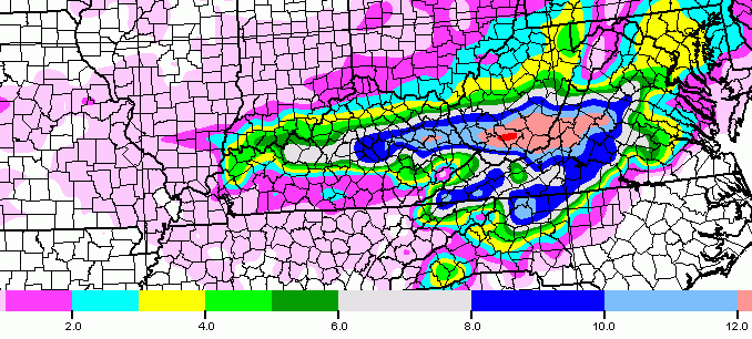
Sleet and freezing rain show up well on the same model run…

The GFS is also going toward a pretty significant hit. The snowfall map…
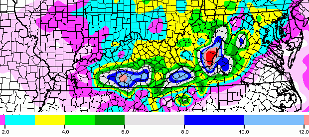
Here’s the sleet and freezing rain forecast from the same run…
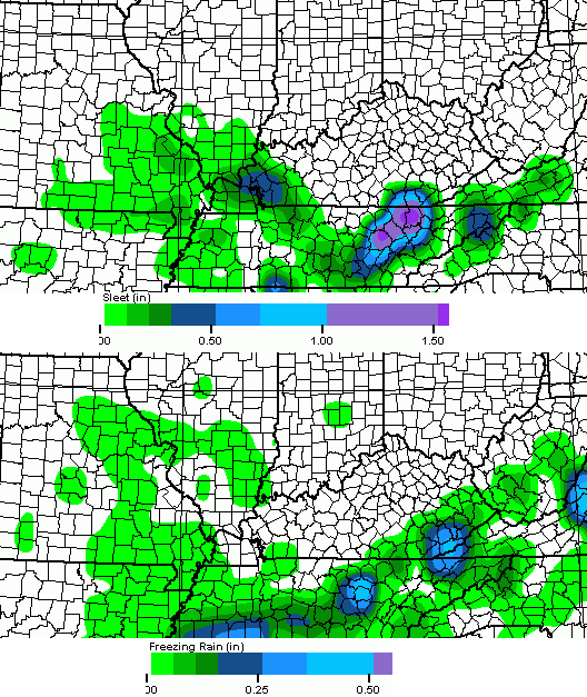
Both models are still trying to produce some rain with all this, too. It’s important to note… those are computer forecast models that are subject to change with future runs. With the potential for so many different precipitation types occurring with this storm, you shouldn’t take any one map to heart. This will be a tricky accumulation forecast!
I will try to tackle that forecast with the First Call For Snowfall/Ice on WKYT-TV starting at 4pm. I will also update things later this evening.
Stay warm and take care.

I’ll take 8-10 more inches of snow please… and no ice.
I am with you 100% about the snow. Keep out the rain and freezing rain. Slow melt would be better than ice or a deluge of rain like they keep talking about. Accuweather/Weather Channel still on the rain train for Sat/Sun.
8-10 of heavy snow actually can be worse than ice. Hard to shovel, even heavier and roads are more of an issue as well.
I will still take it over rain or ice. A little ice can cause a lot of problems. As for rain I would rather do a flood cleanup.
I mean rather not do a flood cleanup.
Thank you for all you do to keep us informed. You are the best !
I think it will trend to a all snow system with a statewide 12+ inches
I hope your right that it is all snow. I HATE Ice.
Thanks Chris! We really appreciate how you add your forecasting skills to all the data and models y’all sift through.
Yes, this looks like a real headache and head scratcher to forecast.
Stay warm folks.
Get some rest between now and then. Thanks for all you do!!?
A bad trend! If it keeps going south then the usual Northwest jog, then we could be in for some nasty ice! Only good potential for this is if it stays south and keeps KY on a snowy side. (Which I’m sure not many of you would mind)
This has more of an ice feel to me than a snow feel. I’d much rather have snow except this will be a heavy wet snow if it materializes…and power outages are the result of such a snow. It is very interesting that both the nam and gfs made a significant move south in the 12z run.
50/50 right now.
Thanks for the update Chris…Looks like a nasty weekend ahead of us be prepared for all forms of precipitation. I for one hope we don’t get ICE!
If it snows then won’t it be a heavy wet snow? A snow of 4-8 inches in our area could be very bad….lots of trees. Thanks, Chris for your hard work & dedication.
Yes…moisture-filled system.
6-12″ of snow this time around would potentially knock out alot of power.
Thanks for the update!!! Looks like we might all need to make another grocery run!! Please snow and not ice. Look forward to your update at 4. Keep some rest until then, sounds like it may be a rough weekend again.
Yep…start making out the grocery list. I have a feeling that we will be in school in June…again!
Our last day with JCPS in LOU is now June 1. Now another crazy weather system this weekend. :o) Still would take snow over ice any day.
this from Marc Weinberg twitter:
Marc Weinberg @MarcWeinbergWX 38s39 seconds ago
Said this go a couple of days… Fri- Sun needed to be monitored closely as data seemed to being having issues. I think we have a problem.
Dont tell Whas storm team that. You watch if the models continue showing snow and ice as the predominant precip type Whas will say we were the 1st station to tell you another winter system is on the way.
haha
Got that right! Folks need to turn from the “dark side” and switch to this site. 😉
I should also add that a flatter solution means there may not even be a surface low develop. That would minimize the northern extent of the warmer air. The ripples in the atmosphere just move along the warm front triggering moisture…most likely ice in a warm front scenario.
is that you, Tom Wills?
lol
Of course not…
Signed,
The Spirit of Wave Country
The nws in Jackson issued a winter storm watch, for significant snow of 4 or more inches, and significant ice possible as well.
The HPC says this is going north
http://www.hpc.ncep.noaa.gov/wwd/day3_psnow_gt_04.gif
It may be old data, not sure
I’m not sure but that does look like the old track.
Old, vinny….from 2:30 this morning, I believe.
Says issued at 731z so that is 2:30/1:30 AM Eastern/Central
That is 731 this morning I believe.
Could the NWS in Louisville be next? I think it’s a matter of time.
Funny, most of us were dissing rain this time last week since looked like what we would have form the last event, but now most of us are hoping for rain and could be opposite. Irony!
SNOW SNOW SNOW 😉
We are a fickle bunch. 🙂
guess I gave WLKY too much credit.
They basically just repeated the WHAS11 forecast.
Said 1-2.5″ of rainfall with possible thunderstorms (what?)
Said only from Seymour, IN and points north would see accumulating snows.
If blindly looking at models and not considering the data they use for outlooks, not a surprise. Just like Crackuweather.
Not to be confused with smokin’ it…
lol
There just wanting to see more model data playing it conservative. Whas and Wlky are notorious for doing that. They will come around both of them stations remind me of the GFS late to the party.
the variation in these weather forecasts do nothing but confuse people.
They could at least put in there, the bust potential on a system like this.
Sorry folks, I’ll be the outsider and say those maps are making me sick to my stomach. I’ve had enough…
LOL – Dare I say – Me too…….I’ve totally had my snow fix…..And to think this is all happening in mid and coming up on late Feb instead of the heart of winter…
This. Meh to snow and Bleh to ice! 🙂
Hopefully after this weekend we are not this: 🙁
Think plain rain! 🙂
Yes! Rain!
Rain! Rain! Rain! Yes!
Historically, is February our worst month for winter weather? I am so over this! Reading all the maps and comments makes my head hurt. Snow or ice? Just tell me so I know whether or not to head even further south! =)
trying to make sense of those pictures. so… looks like more in south and eastern if something happens??
what does this mean for lexington? we have a lock-in scheduled for friday night and I’m trying to get the best info before deciding to cancel or move forward.
How much snow for Louisville area? Will this blow up into another big storm or fizzle? Will it drift more north? I am certain I do not want rain, but not ice either. Maybe that sounds picky.
I am not sure we want anything from this but plain rain. That is if one likes having power as an example 🙂
Do not want power outages, that’s for sure.
whatever falls, it is not going to fizzle.
Looks like it might be a weekend to stay home and watch our cats and movies.
I think I am at the STL (snow tolerance limit) after driving on back highways to get to work all week. Drifts so high on road from Burgin to Danville, I had to drive in the opposite lane for a mile. If we get the freezing rain or snow these models are suggesting, I am wondering if the gutters will fall off the house. I am thinking I need to go home and shovel the five foot snow drifts off the back deck to get the weight off before this hits. Anyone else doing that?
With all the info out there, what is the best likely scenario for us?? NWS Jackson has already issued winter weather products and that scares me, lol. They’re never at it this early in the game. Even if we get rain, with more cold air coming in behind it, wouldn’t that add a layer of ice under the snowpack?? I’m weather illiterate, so any help is appreciated! Just curious… 😀
Models last week had the storm all south until 24 hours out. Hopefully they will correct this north trend and move it south, best case scenario.
I’m waiting on the 0z run of the NAM this evening…won’t be able to review the data until I work another brutal shift at the airport. Although this latest run (12z) is starting to sniff out the snowpack at the surface. There will be better data sampling this evening but I would look for more ice potential in the next run. If we here in Louisville and Lexington get much more snow, better start shoveling rooftops pretty soon.
Especially if it’s a heavy, wet snow.
Basically, if you live in southern KY (London,Somerset, Corbin), pray that the GFS is spot on. The NAM drops a nasty load of freezing rain and sleet on southern KY. *If* that were to verify, power outages, tree damage, etc would become a serious issue down this way.
You are so right we are still buried here.I will have to say all our workers here have been great.The City Police Fire the road crew God Bless you and Thank you.Thanks to Chris and all the team too what would we do without you?
Looks like after the northwest shift folks in southern Ohio will be getting the snow and folks in Kentucky will get the ice & Tennessee/ky border will be plain rain
Thank you for all of your hard work and dedication! You predicted all of this back in November. Very impressive! 🙂
NO we don’t need this, GIVE ME RAIN!!!
Rolo is not even calling for Oldschool, so means even he has had enough.
Mother nature must be amused at out sudden turning.
our
I know, before last weekend I would be begging for this storm. Now, I wouldn’t mind the rain.
My friend I am with you there.This is one time give me the king and KY Rain.
you can have the power outages that go with us rolo. Don’t be wishing that bad stuff on us
No, I am hoping for ALL snow. This has been the whiniest blog about “virga”, “blowtorch”, and “the dome” over the years. Here’s to an “old school thumping” that will give you guys your fill for about ten more years. Sometimes you get what you ask for…
Meh
Amen to that!
The fact that so many now want rain….that’s a recipe for disaster from mother nature. She is going to give us all a boatload, except in frozen form!
Hate cold rain, bring on the snow, spring starts march 20th, it is still winter folks!
I see NWS has now issued a Winter Storm Watch for Central Kentucky. Seems like they are getting more confident this will be a mess.
Winter Storm Watch now posted for most of Kentucky….Paducah NWS still hasn’t posted, as of yet.
NWS jumped the on the rain train a little to soon looks like, they must feel like champs with all the models shifting south at the moment!
I bet WHAS and WLKY are feeling pretty good about their forecast released just 2 hours ago, too 😉
They did way too early. CB and Marc Weinberg both were skeptical about this weekends scenario. Props to them while every other met jumped on the rain train.
its funny some of the ones begging for an old school snow are now done with the snow ….1 or 2 weeks of true winter and they r tapping out ….I guess watch what ya ask for lol 🙂
You are right I am guilty too. Dont’ get me wrong I love snow very much,I am just concerned with more snow before we get rid of some of what we have I am afraid of the roof caving in but I wanted I asked for it I got it loved it while it’s happening but I have learned exactly what be careful what you ask for means. I have also learned the best places for quick shots in the house being locked in with my hubby all week.
I am all in for more snow. I hate the thoughts of rain/flooding. I prefer a slow warm up and melt. But I hope Winter hangs on a few more weeks.
Bring it on!! Thanks Chris Bailey for all you do to keep us informed.
NWS conference call starting: still going with cold rain on saturday, but acknowledging that models are trending colder.
But yet there is a WSW
NWS is STILL riding the rain train even tough the models have trended significantly colder! According to the NWS conference call.
wow, NWS sticking to their guns in their conference call.
Saying low impact snow event 1-3″….with best potential for 3″ in central KY.
Very confident still that this will all turn to a cold rain Saturday with 1″ near the river and higher amounts south.
Ice won’t go reach 1/4″ in any areas.
Did acknowledge the models trending colder, but just isn’t as enthusiastic about the heavy snow and/or ice potential.
Very interesting….seems like a contradiction from their WSW release.
Also, just noticed Watches being upgraded to Warnings in Tennessee and parts of Arkansas.
It does, I’ve been following the conference call also and they’re REALLY sticking to their forecast of a warmer scenario!
You know what? Maybe they will be right, along with WHAS and WLKY….
I guess posting WSW kind of covers them just in case their conference call analysis is incorrect.
I hope their guns are on target- this time 🙂
They said the same thing a few days before our current event- as far as Kentucky not getting smacked. That worked out great, huh?! 😉
That conference call was about as clear as mud. Why issue a WSW if there is low impact???
Hey guys…we have issued a WSW for a low impact event.
woo hoo!!
Yeah that confuses me, the nws in tn have posted warnings for snow and ice. The American models have been better with storm placement this season. Some mets in nyc blindly followed the euro back in January and had to apologize for the nyc blizzard bust, the American models pegged that system.
Yep on this!
I have noticed that the NWS would rather upgrade last minute than to down grade last minute, as far as winter weather goes! On the last storm they waited until last minute to raise snow totals.
hello from Littleton, Colorado. we are expecting 12-18 inches here this weekend. looking at the latest modeling I think the models just now see how flat the trough will be, this pattern just doesn’t support the more typical amplified low pressure tracks of the last several decades. ky maybe about to play catch up when it comes to winter I am feeling 🙂
This weekend storm sounds as though anything goes. Believe me, when we have had this much snow on top of a very frozen ground, rain is not a good thing. Yes, the gutters are frozen and rain can back up as it did on us, and it came in through the roof and ceiling around our fireplace. There I was at 2:30 a.m. trying to get the two inches of water out of the living room carpet. Whatever falls this weekend, I hope everybody continues to have power. Cold air is coming in behind this storm. Stay warm.
winter storm warning for all of the Nashville forecast area
Anyone know what their saying for southern Ohio?
We are going to get boinged again . Lets wait and see what chris says.
this low is much weaker compared to 24 hours ago…that means less/no turn north eastward. with weaker low less warm air is drawn northward. yesterday it seemed like a Oklahoma to Michigan track I think It eventually will end up being flat and will travel the 35-36N lattitudes.
Marc Weinberg @MarcWeinbergWX 8m8 minutes ago
Very surprised the NWS never mentioned the cold pavement temperatures prior to this storm and the impact it will have.
Marc Weinberg @MarcWeinbergWX 6m6 minutes ago
I think the icing seemed to be played down too much
I would say Chris Bailey feels similar to what MW does.
Yup, NWS in Nashville pulled the trigger and issued a winter storm warning! This storm has the most debates and scenarios I have seen in a while! We are two days and every forecast is different.
Yes, someone is going to look like a genius and someone is going to look like a donkey
At this point, the best hope is that the storm never really gets cranking and isn’t able to throw a lot of moisture up over the state. Even if the model runs are colder than they have been, southern areas of the state could have a real mess with snow ice and rain. And over deep snow pack, that’s a recipe for trouble.
The NAM seems to be leading the way as far as sensing a weaker storm with a more southern track and that would be a good thing. With another arctic blast heading this way, the last thing anyone would want is a replay of 2009 with power outages.
The new bam is coming out now
Nam
winter storm watches for Louisville forecast area now
No one seems to have a great feeling about this storm. The NWS in Louisville is calling for 1 to 3 inches of snow in Louisville, then sleet to finally a cold rain. Indiana areas would get rain in the afternoon. But they did say the models are trending colder.
Up to 3 inches of rain in the Bowling Green area and about 1/2 to 3/4 inches of precip in the Louisville area. Precip would end quickly up here, but last longer east.
I’m up here on a “mountain” in Boyd County wondering if I need to make grocery run before the weekend. :/
yes, because the storm is now more flat.
lol
So hilarious. 😉 I’m getting low on chips & adult beverages. Cats are playing so this is serious business here.
Anyone have some thoughts on the Morehead/Ashland area with this storm? We have a ton of snow here already and roads are snow covered with a solid sheet of ice underneath.
Nam says not so fast, heavy rain
00Z runs will be the ones to pay attention to tonight.
06/18z is an off run.
So what we appear to have is a coin flipper.
I bet the nws in Nashville wished they would have waited to issue those warnings.
I think it’s a good move on their part.
The bam corrected to give ky a bunch of junk, snow, ice, rain, sleet hail freezing rain,
Back to 32/33 with a very cold ground might I say.
As usual NWS in Charleston is asleep. They like to let everyone else do their forecasting then come in last….zzzzzzzz
How true that is.
SNow and Ice go away and don’t ever, ever come back. I guess those who wanted the “big one” got to spend the last fews days inside and not working. Those of us who had to get to work through all this mess are ready for spring.
well 4-8 inches snow then half inch ice then flooding GRRRRRRRRRRRRRRRRRRRRREAT!!!
Best comment nomination….
I jumped the gun, the nam corrected and is similar yo the last run, a mix of crazy.
yes, still the 00z runs will be very telling!
Here’s my take..The good news is probably rain sometime sat..Bad news Friday into Sat. snow and freezing rain and maybe lots of it..Hopefully the Nam goes back to being it’s silly self..
Wowwwwwww. Can anyone spell ice storm?…..
Did anyone else come out of that conference call being confused?
If they issued a WSW for our area, then that means they are somewhat buying into the colder solution. However, stuck to the warmer solution during the conference call. They called for 1″ to 3″ of snow/sleet for our area, but mainly said the 3″ totals would be areas around the parkways. With total liquid precip of the storm being around 3″ in the parkways and only 0.5″ to 0.75″ by the time you got to I-64. That seems like a very steep decline in precip in such a short distance.
So basically, from what I got out of their call is that Frankfort would mainly get 1″, maybe 2″ of snow/sleet, and then rain. So, why issue a WSW for that?
If they are trying to cover themselves, it sends the wrong message. Most of the public thinks a WSW will turn into a Winter Storm Warning. When you go from a watch to an advisory (which I am guessing at the moment Frankfort would, because it is no where close to meeting a Winter Storm Warning criteria), people think its a downgrade. Was this not the situation in Atlanta last year when the NWS there went from a watch to a advisory, so one really paid attention to it.
I do believe NWS is really down playing this storm. Guess we will see what they say in 24 hours during the next conference call. Also, less confusing.
On a side note, I watched a weather briefing out of AR and they did not have the freezing line lifting to the northeast of their area until the 4am-6am time frame Saturday. However, our NWS has places around the BG area changing to rain by morning as well. I might be missing something here, but if places in AR are just switching to rain during that time frame, how are the places around BG doing the same?
to answer your question…NWS confused many (incuding well respected MET’s).
could central KY get a warning
CB,
Please stop your foreboding tweets 😉
Do we need to get Vanilla Ice here, or CCR with “Who’ll Stop the Rain?”
I prefer CCR regardless, but CB might suggest “Bad Moon on the Rise” as far as the weekend 😉
Not Vanilla Ice. He’ll steal us blind!
Maybe this storm will catch everyone off guard so no one can hoard all the bread milk and beanie weenies..Plus the bathroom tissue..lol
Sun suppose to be out tomorrow this thing could hinge on how the temps go tomorrow.
I still say bring out the boat
Surface temps will have a lot to say about freezing rain..Nam probably is correct on the temps..GFS maybe moisture..Gonna be a hard forecast for the pros..
boat….not unless it has ski’s underneath.
boats don’t go on ice my friend they get stuck like everything else
They hit the bank…snow banks and drifts….not exactly run aground…but close
I’m nervous and excited all at once. It will be very interesting to see how this plays out.
Timing on all of this mess to start in sc Ky? I’m a little house burned, but I’m okay with snow…Definitely no on ice and even rain.
All of the different outcomes hold their own short term or longer term problems.
It’s like the weather version of the Aliens vs. Predator.
http://i.imgur.com/b9s3tIP.jpg
NWS in Paducah finally issues a Winter storm watch for all of western KY and a good chunk of southern Illinois and Indiana.
I’m sorry, but I just see a widespread Ice Storm along the pkwy’s….Bardstown always gets hit, I’m right up there in it this time, too! Been a while…been thinking about it for almost 2 weeks now…I told my fiance last w/e we’d get around 9-15″ snow…he was like, “Is that RIGHT??!”..(blah…) Well, reckon he needs to open up those ears….about 11″ -/+ worth….??!
All of ky now under winter storm watch
Pandora.
Please don’t look inside that jar. I’m afraid to see what’s in there.
from Repo Man: “Don’t look in the trunk. You don’t wanna look in the trunk.”…..yet they did!
Just saw Chris’s WKYT forecast. Calling for “the trifecta” of snow/sleet/freezing rain with high confidence.
Is it similar to the map that was tweeted earlier?
I’ll let Chris spell it out, but basically decent snow and ice likely for northern half to 2/3 of the state.
Even Chris said his forecast will probably change as this one will be a tricky forecast. I believe we will need to wait until tomorrow to find out
Oh yeah no doubt.
I’m checking for updates here more than I am Facebook.
No one here ever sent you a Candy Crush invite
Ha! True.
Me too. I have been watching WKYT news cast all week and I usually don’t watch any of the news that often because I check the internet instead, and he seems to think even though the storm is weaker and further south, it’s a juicy storm with lots of moisture. To me, that sounds like a strong storm…..He said whatever falls there will be a lot of it……so I guess weak storms that travel further south can have a lot of precip? I dunno. Definitely an exciting and exhausting weather week.
I saw that! I was able to watch online. Didn’t even watch my local news. Lol
Chris Bailey really is on point with his winter forecasts. Ole Lex18 and the rest of them never seem to identify the correct solutions…