Good Monday, everyone. Our last week of the month is off and running with another blast of arctic air across the commonwealth of Kentucky. This continues to be part of an overall wicked cold pattern for much of the eastern half of the country. Guess what? There’s a growing chance we carry the colder than normal stuff into the first half of spring.
Today’s cold will be accompanied by gusty winds and the chance for some light snow and flurries early. The best chance at seeing some flakes will be across the east and southeast. Afternoon temps will struggle to get out of the upper teens in the north and west as the far south and east hang a little higher. Gusty winds will make it feel much, much colder.


The real deal cold settles in tonight as temps drop below zero for many areas and that could mean another round of records being shattered. Wind chill numbers will be even lower.
Another arctic front arrives Wednesday with the chance for some light snow action. Another shot at single digits or lower will sweep in after that for the end of the week.
This is an intriguing pattern in the upper levels. The jet stream is digging deep into the south, allowing for cold air to engulf much of the country. There are many disturbances diving through the base of this trough and any one of those could try to really blow up. That may not be something the models can pick up on until a day or two before it happens.
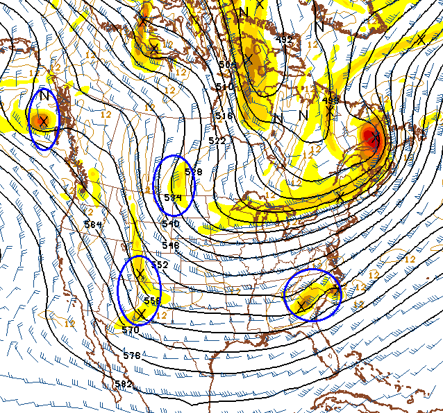
The more I look at this kind of setup into early March, the more I wonder if some kind of monster storm system can come from this. I’m not necessarily saying that would hit us, but some kind of HUGE storm is possible as anomalous cold air encounters the seasonal transition toward spring.
Speaking of spring and colder weather, the long range CFS keeps the below normal temps through early April…

There really is nothing pretty about that map. Nope. Nothing.
I will have updates later today. Take care.

Thanks for the update, Chris. Sounds like old man winter is extending his stay for awhile!
I hope this doesn’t happen. Hopefully March is warm and dry for the East and the West coast gets record rain and Alaska sees near record cold.
And we get record warmth and drought?
Can’t speak for any of the other school systems but I’m hearing that the expected temps of 0 to -5 from last nights forecasts played a significant role in calling school today for Madison due to how it would impact roads and students.
It was 30 degrees at midnight. It’s still 22 degrees at 6:30 A.M
Good news for those of us driving this morning, not so much for the school systems.
There’s no discussion, so any of the more knowledgeable here care to explain what happened? It seems odd for ALL of the models to be 20 or more degrees off within just a few hours of time. Did any of them call the temps correctly?
No discussion, but they are off big time on temps so far and that is fine with me 🙂
As far as school, it was a smart move. There was melting and ice this morning on roads with minimal wind to dry the roads off before freezing. Better safe than very sorry.
As far as a monster storm for March, it might be or not the frozen type, but a monster chance none the less. Big cold and big warm smacking together could be rough weather.
Your post is a stark reminder that every season comes with its unique set of weather issues. I want spring to get here just as much as anyone. But like you said…big warm air systems knocking heads with big cold air systems in March could very well mean a different kind of monster storm. The kind none of us want to see.
Only a couple severe storms in Louisville last season. So it was a quiet season. Hope we have two in a roll, but I do understand BubbaG’s thinking. Moster translates into Ice or severe. We already had our snow so it won’t be that.
Ugh….
I have seen big snows in my part of the world in March.
I don’t want any part of it this year.
Next week needs at least two dry, sunny, 45-50° days so the new home is completed.
Let’s save the big snow for November or December 🙂
Over the past decade I believe our biggest snows have come in March. Time will tell.
Yeah…over the years I have learned that March can be a downright scary month in Kentucky with the potential to throw everything but the kitchen sink our way. As you indicated…some of the biggest snow storms. And yet some of the worst severe thunderstorms and tornadoes as well (thinking specifically about March 2, 2012).
It stayed cloudy most of the night therefore not much radiationally cooling took place as originally thought thus keeping temps in check.
So glad to be off through Friday this week. Another nasty respiratory infection to fight off.
Thanks Chris. Guess we will need the winter gear for a while yet. Thinking Spring. Have a greT Monday everyone, if Monday’s can be called great. But we gotta have them to get to Friday! Stay safe and warm today weather friends.
Woke up to 29 here in Topmost of Knott County around 7:15.
Same here but it’s down to to 27
Thanks for the update CB. I feel we are not finished with the snow and cold either. March looks to be brutal when it comes to temps below normal. I forsee a messy mixed bag of precip for the entire state over the next month. Looks like we are in for another cool summer as well. I believe this is the norm for a few years to come, so if you have a pool you might want to invest in a heater or ice skates.
Think Snow! Or if your name is Vinny, Think Spring!
The wsi disagrees, they believe this spring will start off below normal, but as we head toward summer we will go above normal here in ky. They point to the drought in the plains combined with the pacific being well above normal temps, creating what they believe will be a hot summer. Plus I believe Chris mentioned we could be in for a blowtorch this summer.
I approve this message
Rodger can’t remember such a prolonged cold snap this “late” in winter. Then again, his memory isn’t what is used to be.
Would be a shame to get a cold week and warm up to rain on Sunday. Then again, Rodger guessing some snow fans on here might be OK with that by now.
Rodger in Dodger!
I picture you being a Ventriloquist and having a puppet on your hand named Rodger
Just full of GOOD news today, huh? Lol
I appreciate you and the work you put into keeping us informed!
Thanks!
Not that we haven’t had a nice week of snow fun, but it seems a shame to see snow makers going south of us this week. Oh well…bring on Spring…in that gradual no severe outbreaks kind of way.
Good news there’s a nice warm up coming next week. 50’s degrees is forecast.
The NAM continues to trend northward with the mid week system. Wouldn’t be suprised at all if southeastern ky gets a little somthin out of it. Something to watch anyways with our history of the nw trend
Yep..Will the theme of winter continue with the NW shift..Could be another golly whopper..
I’ve been saying this for a few days now, but there have been some on here going against it. Like I said before though, definitely deserves to be watched.
I figure if it does trend North it will bring the dreaded southwest wind along with 34 degree rain like last Saturday
Freezing drizzle here in Knott County at the moment.
12z NAM SAYS LOOK OUT DIXIE STATES!!,6+ INCHES OF PINE SNAPPING SNOW!!
Anyone think Fayette County might call off tomorrow due to temps? I was surprised they had school today.
We live in Hopkins county ky. I wish you would tell a little more about our weather. We had 12 inches of snow and it’s still hanging on. I really like your reports but wish you could mention ours little more. I look forward to your report every night. Keep up the good work.