Good afternoon, folks. Arctic cold is back in control of our weather after a brief break over the weekend. Additional pushes of very cold air will be on display later in the week. But, what about the snow chances? That’s something we will have to deal with on more of a short term basis.
Tonight’s temperatures are a bit of an enigma. For areas with a deep snowpack on the ground and clear skies… readings will drop toward zero and below zero. Some clouds may try to hang around and clouds at night act to keep temps up a bit. Wind chills will be much colder than what your thermometer shows.
A storm system will be developing to our southwest on Wednesday as another disturbance dives into the Midwest. If you want snow around here, you want the plains system to interact with the southern storm and lift t farther north. The models continue to keep these two systems separate, but are a little closer.
The regular version of the NAM shows the separation…
The simulated radar from the Hi-Resolution NAM shows a bit more interaction with our southern system creeping farther north…

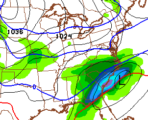
The latest SREF looks similar…

Can we get the famed north trend to kick in with this system? Time will tell, but this drives home the point I’ve been making about these systems only really showing up within a few days.
Even without the storm across the southeast, the plains system should bring a swath of light snow in here Wednesday night and Thursday as arctic air follows.
I will have another update later today. Take care.

Ok, that’s enough! lol
it can wait to snow on St. PATTY’S DAY. I’ve always wondered how it would look see green snow falling. 😛
I while drinking a nice cold Killian’s Irish Red.
Green snow would be kinda cool.
I still want my 4 seasons. It’s still winter so let it snow. Spring will show up next followed by summer.
Agree 100%
Kentucky
Spring: May
Summer:June-September
Autumn: October
Winter: November-April
Snow on the ground for the last two Octobers, let’s share it with Autumn and Winter.
I enjoy reading this blog. Even when the storms don’t always cooperate, it’s the chase that is exciting. Last week was of course a dream come true for a snow lover like myself. I am secretly hoping, wishing, praying for a northern shift. I wouldn’t mind for the NAM to go BAM or drop the mic or what have you. If not with this one, at least once more this winter! All the snow lovers unite and push this thing north! (sorry spring lover friends, I hope you have to wait a few more weeks!)
I couldn’t agree more.
Well, I guess Ill be checking back to see if these storms meet up .
Hoping nothing major blows up around here. Trip to Wisconsin Dells over the weekend. Don’t want to have to stay home and work. I am wore out from this week my salt supply of 2200lbs of salt is down to 500lbs. Hopefully I don’t have to purchase anymore. But will if I have to.
Thanks for the update Chris.
I’m rooting for you.
Save the salt for the Irish day.
if these two lovers meet up
there is a 80% chance that it will move north
Everyone keep us updated on the trend of that storm. Is it possible for it to shift that much north?
The storm that moved through Chicago a few weeks back had Ky in the prime snow four days out. More the 200 miles in less than four days.
Ah yes, the sudden northern “pull out” that prevents the storms creation process here. It certainly has kept our overall storm population to a minimum.
I keep hearing talks of a weekend storm possibility. Is this what everyone is talking about?
It will probably be a rain maker court051
My area has 40 to 50 degree highs for this weekend with rain forecast for Sunday.
Yea mine too. I’m just in Boyd County. Part of me was hoping that would change. Lol I just want one more big snow. I know I’m crazy but when it’s winter (which it is) I want snow. I love all the seasons. Although, I’m not ever happy about the thunderstorms. Ever!
Who on earth (at least in Kentucky) wants more snow!! So ready for spring.
Me
me
Im with Kim on this one.
at least your honest 😉
with almost 4 1/2 feet of snow here(Beckley WV) since 2/12 …and according to the nws still a 27″ snowpack …8 straight snow days for the kids…I say to mother nature ,” is that all ya got” ? bring on the NW trend…more snow
I’m with ya. Hold off Spring as long as possible. Your part of WV and mine are world’s apart in Winter. This past Saturday was the ugliest day for me in recent memory. Pouring rain, fog and slush. I also can’t recall a 55 degree temp swing in less than 24 hours. The southwest wind is king in my area.
18Z NAM continues NW trend of southern storm.. southeastern KY be on guard!
Bell and Harlan Counties definitely do not need anymore snow right now. Keeps looking more likely they are going to get some though.
This!
GFS has kept the storm well south, 18Z GFS run will be interesting. Not sure what others models are showing, NWS not seeing anything significant at this point.
Done with snow here! Stay away from north Madison 🙂 Thanks in advance!
Counting our 1″ prior and the 16″ from last week, 17* is enough.
Question: I notice after this really cold week, it looks like Saturday is forecast for 37, then Sunday 50! Is this a short lived warm up? Or will that even happen at all? I know a lot of times the end of the 7 day is not really accurate…..
I enjoyed the few snow days off, but no more! I don’t want to be in school in the middle of June.