Good evening, everyone. The bitter cold is back in the bluegrass state as temps drop toward record levels again tonight. We know the cold is here for the week, but the snow chances aren’t as clear cut. It’s a suppressed look with the overall pattern, but a few systems are will try to make a run at our region.
The first system scoots across the deep south tonight and throws a period of light snow into southeastern Kentucky. The new Hi-Res NAM simulated radar shows this well…

That could throw some light accumulations down into our far southeastern counties.
The next system is much stronger and continues to show up farther north and west on some of the latest data for Wednesday night. The Hi-Res NAM siimulated radar…
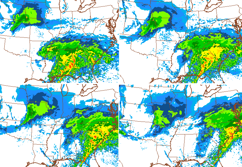 That system diving in from the plains is trying its very best to tug that system closer to Kentucky. Let’s see what trends emerge overnight into Tuesday.
Regardless, he plains system will bring snow showers and flurries in here on Thursday.
On another note… we really need to watch late this weekend into early next week. A lot of possibilities are on the table during this time!
Enjoy your evening and take care.

How I feel about winter at this point
http://m.youtube.com/watch?v=uL0psyzspyM
LOL
I’m so torn. Loving that I went ice sledding today and kinda wanting things to get back to normal and back to school. Oh well, a few more snow chances could be nice I suppose.
My grandkids got out sledding yesterday! It was great!
Hopefully I’ll finally get a good snow here in east tn..
Hope you get several inches. My uncle lives in Greenville, TN. Is that close to where you live?
Not sure..I’m in between crossville and Knoxville
He lives close to Morristown, TN. My grandmother was in the nursing home there. We came down about all the time to visit her. Not to far from Knoxville.
I spent part of my early childhood in Morristown, not far from where the building and radar for NWS Morristown would be built.
I’m pulling for you tim, I myself am ready for spring.
Wouldn’t care for it to scoot a little bit farther up into southeastern Ky and would give us a pretty white coating on top of our snow we have left here.
Not sure the current snowpack will melt very much this week. I’m totally fine with adding to it. I’d rather there be snow on the ground than see all the depressing brown yards.
If we get more ill take it but if we don’t that’s ok too. But if it’s going to be this cold it may as well be snowing, right? Have a safe and warm evening a. Thanks for the update Chris. Appreciate the hard work you put in to keep us safe and informed.
11* in NW Lexington
They FINALLY plowed my street today. Only took them 7 days to find Masterson Station
I know those men/women work hard, but why does it take so long to get your street plowed in a city the size of Lexington? Plus a subdivision the size of MS.
Dreaming of spring
That’s weird. I think ours (across Leestown from you) in McConnell’s Trace, got plowed thursday I think? It was a few days ago but can’t remember which day…..before that, streets were terrible. It’s amazing we had over an inch of rain and all this snow is still here.
My street didn’t get plowed until yesterday
Remember that storm a few weeks ago where the Northwest trend kicked into high gear and slammed Chicago with a foot and a half of snow? Well that storm started in Kentucky on the models days out. For our winter storm the models had a snowstorm for central Georgia, the trended north in KY. It seems the north trend is so strong that we could probably only repeat events like this if a snowstorm is forecast in the Gulf states at least 3 days out, or else it’ll go north of us.
Also, on another note, CB says “another note… we really need to watch late this weekend into early next week. A lot of possibilities are on the table during this time!” If you have carefully read this, you would have noticed this is different from what he usually says a week out on potential winter systems. Pay close attention to “A lot of possibilities are on the table during this time!” It seems almost certain that we’ll warm up quite a bit this weekend, and what usually comes with warm weather in late winter/spring? Thunderstorms. Again, “A lot of possibilities.” Not saying we’ll see severe weather, but it might be a possibility? Arctic smack follows that, so maybe another winter storm? I don’t know, but just analyzing and reading between the lines.
If the GFS comes anywhere close to verifying for next week flooding would most certainly by one of those “possibilities”.
Happened to notice The Weather Channel “forecast on the 8s” have had very warm temperatures this late weekend. One of course has to take this with a grain of salt so far out (IIRC, The Weather Channel “forecast on the 8s” uses straight out GFS with no human intervention – someone can correct me). But other models seem to be showing warmth as well, if only a brief warmup.
One thing that could fuel any severe wx chances this weekend is that the Gulf Coast waters are unusually warm for this time of year, despite Florida and other coastal states finally getting a cold blast last week.
I believe TWC does use raw #’s straight from the GFS. It seems like it because I’ve compared and they look nearly the exact same. The only exceptions I’ve seen are crazy numbers. TWC “local on the 8’s” had negative teens or 20s or so in the forecasts when GFS was consistent in bringing -30°F temps to Lexington.
It’s still winter. If there is precipitation, I do not want rain, I want snow. It’s actually rather saddening when it gets cold and dry, then wet and warm. Knowing it’s winter, and picturing the rain as snow is tough.
Yes! What Lucy said! 🙂
00z NAM is continuing its northwest jog for Wednesday/Thursday storm. Bell, Harlan and Letcher counties under a winter weather advisory for 1-3″ of snow tonight and tomorrow.
Yep .. NW trend continues on 0z NAM.. Let’s see if GFS Begins to follow the trend
Channel 8 out of Knoxville is saying 2-5″+ for Middlesboro by 2pm Tuesday.
Nooooooooo!!!! I love snow but enough is enough. Harlan is still buried we don’t need anymore. Enough houses and buisnesses have been damaged or destroyed. We need a break please.
Oh please, NO! Had enough snow!