Good evening, gang. I wanted to drop by for a quick update on the wicked winter weather that continues around here and for much of the country. Our Wednesday night snow system continues to look to deliver a glancing blow of snow to Kentucky.
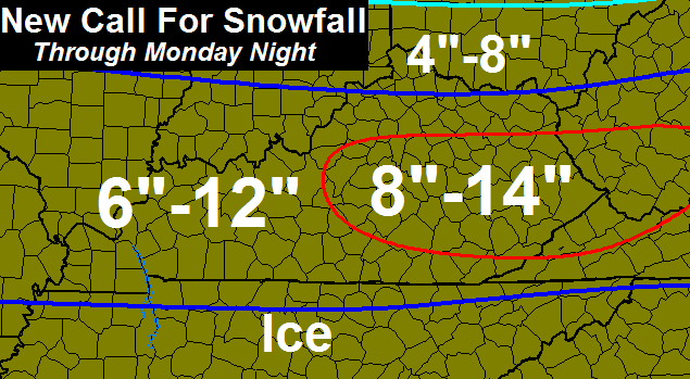
This is a major snow maker for areas of the south and southeast. Here’s my First Call For Snowfall across the state…
I’m really watching the pattern from late this weekend into next week. This is a VERY ugly setup across our part of the world. I suspect the models will trend colder as we get closer, but the possibilities are endless.
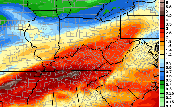
Snow, wintry mix, heavy rain and thunder will all be possible during this time. The forecast models are going crazy with the amount of precipitation they are spitting out over the next 10 days…
GFS

European Model
 There is nothing good that can come from the setup I’m seeing. Nothing!
Enjoy the evening and take care.

Thanks goodness!!! My area is out of the snow range.
Ugh! Sounds like a very messy weekend indeed! I think I will hibernate! Thanks Chris for the update and for all you do!
Thunderstorm season starting early
Why would you say that?
Are we going to get severe weather?
It will be a while before Severe Weather hits from what has been discussed
Decent chance of thunderstorms early next week with the pattern we are heading into.
best get the boat back out for next week.
Looks like a ankle biter for tomorrow night might cover up the brown ground here till the rains come
I’m guessing 4″ for Middlesboro since we’re on the boarder of 1-4″ and 4″+. Lol.
It’s 1-4″+ which means 1-∞”
So do the ‘very ugly’ & ‘nothing good’ references mean amount of precipitation & type…or…possible severe weather beginning?
Repeat of the weekend maybe rain, sleet, snow and so forth
Thanks-I can handle more of that weather. Not yet ready for severe stuff!
I’m hopin them yellow and reds mean warm.
Just color coded precip amounts
Ugly and trending colder could mean ICE.Apps says bring it.
Well we got a huge northwest shift with the last one that nailed Central KY and SEKY was on the low end. Now we just need a slight nw shift to bring SEKY into play and it doesn’t look to move much. Never know with weather.
Apparently NWS Jackson had their system crash and has to wait till the overnight shift to check the next run of models to issue any advisories, if needed. Is the northwest shift still occuring? Lots of winter storm warnings south and southeast of us.
You would think they could ask for some help from a neighboring office on guidance to issue a watch/advisory. It looks to me that several SE KY counties should need an advisory issued.
So true. And what of the clipper that was coming our way? Iowa has winter storm warnings for up to 7 inches of snow. Is that going to make it to KY?
Seems like the went with a special weather statement for the SE counties. They say 1-3″ of snow is possible with up to 4″ for the mountains on the VA border. Seems like that would warrant an advisory.
The clipper looks to run out of steam before it hits KY.
I for one would rather have a big snowy finish to winter as opposed to the kind of crap we had last weekend.
So what them maps are telling me is that we could have up to 3-5 inches of precip. over the next 10 days. If the cold can hang on long enough at 10-1 ratio’s all of Kentucky will look like Boston. I would take 30 to 50 inches of snow. Ha ha.
Looks to get warm for the weekend then cold again next week. Some of the precip has to fall in the cold somehow.
Thanks for the wet update Chris.
Think Snow!
from reading CBs tweets , ive learned that the state of KY is a lot bigger than the Louisville metro area 🙂 very funny
This is still a thing in the Louisville metro area.
Growing up in Louisville, I knew Jefferson, Oldham, Shelby, Bullit, and Trimble because of proximity. I knew Carroll because of in-laws, Franklin due to a field trip, and Russell because of Lake Cumberland. That’s it, I couldn’t even tell you what county Lexington was in because they mattered so very little in the scheme of things to me despite me being a big UK fan.
The funny thing was that back then we had to take a semester of KY history and had to be able to fill-in a blank map with at least 90 correct counties out of our ridiculous number of 120 on the final. I correctly named and placed all 120 and promptly pushed it out of my brain 5 minutes later.
To this day, I still have to keep looking up some counties that get name checked on here by posters.
Is it me or is it warmer than expected?
Looks like we will see lots of cold rain next week.
Least favorite weather ever….
Exactly. Winter precipitation is supposed to be snow. Let there be rain in spring and summer. .
a RECORD FLOOD could be in our future
Or another old skool thumper of a snow. Let’s be a little optimistic. Ha ha. Get out the rain boots going to need them.
I lived on the Kentucky River in 1978 and a record flood in cold weather is the height of misery, in my opinion, and can be deadly. Let’s hope and pray that March is more lamb than lion! Enjoy today’s sunshine while you can!