Good Wednesday, everyone. A southern snowstorm will throw a glancing blow of snow into parts of the bluegrass state tonight and early Thursday. This means southern and eastern Kentucky will have the best chance of adding to those crazy high February snow totals.
The storm to our south will shutdown areas from northern Louisiana through Mississippi, Alabama Georgia and into the Carolinas. This harsh winter period is leaving very few areas untouched.
The aforementioned track will mean a very sharp cutoff to the light snows in the bluegrass state. Here’s my current thinking…
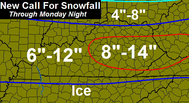
That could change later today as we see just how far north this system looks to roll. The Virginia border counties look to have the best shot at picking up on a few inches. If you’re on the northern edge of the snow map… don’t get your hopes up. 😉
Arctic air comes in behind that later Thursday with a system that will likely deliver snow showers and flurries to much of the state. Minor accumulations will be possible from all that. Temps by Friday morning look to drop back into the single digits for many…
 Highs Friday afternoon may not get out of the upper teens across the northern half of the state. Single digit lows show back up for the final day of February on Saturday. It’s going to be interesting to see just how cold cities and the state wind up for the month. All combined, this will be one of the coldest and snowiest on record.
Next week looks to be super active with snow, thunderstorms, high winds, heavy rain and a wintry mix all possible. Hello, March!
I will update things later today. Here are some early day tracking tools to tide you over until then…


Take care.

I’m just so glad now that we can now *NO LONGER* say areas to the south,north,east,west, have had a big snow but us….Again, we can no longer say that, and THEN some! 🙂 XD
RIP – Feb 1998
The dome still lives in Knox Co. . We only had about 5 inches with the last big system due to the NW shift going beyond where we needed it. Now the next system that comes in today doesn’t get the usual NW shift that would put us in play for bigger totals. At least the dome lives somewhere in Kentucky. Lol
I’m personally ready for it to be over and some seasonable temps to get in here.
It has shifted north, just not as dramatic as the big snowstorm.
With all the city water issues in about 14 counties warmth can’t get here soon enough. The record cold spell is still causing major problems.
What are the odds that this thing keeps coming north and give ashland a good dusting to an inch at least?
Anyone?
Expecting 4-7″ here in se tn…with locally higher amounts…will be the biggest snowfall since valentines day week last year.
Your 1 event could rival what some in SE has had for season totals. Enjoy it ole buddy
Yeah …states of emergency have been issued now for Alabama.. Georgia… Tennessee… Could be interesting later on today..
I meant SE KY
Ashland area could see more than a dusting from the Thurs. event and more from the snow showers to follow on Friday. That’s a possibility that you could get an inch or three? I’m worried about all the rain supposed to be coming in late weekend into early next week. I would rather it be snow, but we have had enough lately. Thunderstorms? I hope not.
I didn’t realize there was snow for Thursday/Friday. I just thought it was Wednesday night. I hope we get some more. Hope you’re right!
50,s are showing up next week, dare we hit the 60’s the following week.
50s on Sunday and already saying 60 degrees on Tues next week, along with thunderstorms. that’s for London/Corbin area.
Joe, I’m sorry, I meant to say that dusting for tonite- tomorrow morning, then snow showers for Thursday afternoon. Guess I’m still half asleep.
I understand! Thanks for the reply!
Have the new nam models been ran yet? What time do they run? Looking for a more north trend! Lol
NAM is running now
Is it going any further north?
And the NAM says…..? Can someone post?
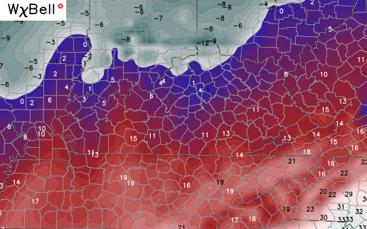
The 12z NAM shows a shut down crippling snow for parts of northern Alabama..Mississippi.. Ga.north Carolina.. Virginia.. East tn..
South eastern ky..gets some snow 2-4..looks like south and west from pikeville to Monticello in Wayne co…
Amazing how a big NW shift doesn’t happen when SEKY is in play. I guess the dome needed to live somewhere in the state. I would really have been disappointed if this was January, but with less than a week left in meteorological winter, the south can have my snow. Long live the dome (at least here). Average temps look to be on the way shortly.
There’s no dome.. LOL that’s a stupid myth. I got 17 inches of snow for the month of Feb and I live in South Eastern ky.
This is the site where “venting” happens not only daily but multiple times a day you know. And where the same lines get used repeatedly in the same posts comments section. And each subsequent. I have decided that many on here are never going to be happy which makes me kind of sad.
Long live the dome in SE Ky less than. 8 inches of snow for the season
What is it looking like for Ashland?
Unless you are on the Virginia and Tennessee boarder not much to see here. 1-2 maybe up here in knott co looks to me. Enough to cover up the brown ground spots till the rain next week I hope.
Feels nice out today working not bad on the temps
How much snow is expected in Knoxville?
Also of note, the 12Z NAM. What is that headed due east on the last frame? That big swath of blue? Could it be? I am by no means a weather model reader, but I am thinking that looks promising? No?