Good evening, gang. Our southern winter storm continues to crank and will deliver a glancing blow of snow across southern and eastern Kentucky. I will get you all set to track that here in just a bit.
I want to touch briefly on the setup from late Sunday through next week. I mentioned the models would try to trend colder and farther south with the overall setup during this time and that’s what we’ve been seeing. To illustrate that point, check out frozen precipitation forecast from the European Model.
Here’s the run from last night…
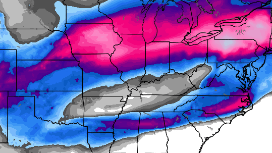 Notice how the swath of snow and frozen stuff was well into the Great Lakes over the next week. Now check out the run from this morning…
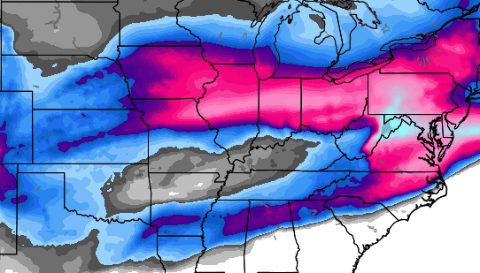 That’s a big shift to the south with the heaviest action and now gets it all the way south of the Ohio River.
All of that comes with a series of systems rolling across the region. Some may roll right on top of us with mainly rain and a brief temp spike. Some might roll just to our south with more of a wintry flavor. The point I’m trying to make is… there is NOTHING “springy” about that look!
Let’s get you all set to track the action moving into the south and east…


Hamburg Area from WKYT Studio
Lexington

I-75 @ Winchester Road Lexington
I-64 MP 97
Winchester
Mountain Parkway near Slade

US 23 at 119

US 119: KY 1679 @ US 119 Pine Mt Road

I-75 at MP 36
London

I-75 at MP 23
Corbin

I-65 MP 36
Near Bowling Green

I-65 @ 234
Near Bowling Green

Enjoy the evening and take care.

Bread….
Milk….
Loving this radar! Looking good for Middlesboro.
Nothing great about a few inches. The real story is south
Heavy snow here at my house in Athens tn area 3″, already
Brandon winter storm warnings..inching farther north almost to ky border now…got 4.5″ here exp. Up to 8″ now..
blizzardTim post some pics on FB. I’ll check them out.
Tim, my parents in Cleveland/Chattanooga TN had about five inches at last count and it was still coming down at a hefty clip.
My brother in north Georgia (Cleveland GA) was also getting heavy snow.
Only started snowing in Nashville TN about two hours ago as it was virga before that. We may get an inch or two if lucky.
Locals in WV have 50 or higher everyday from Sunday thru Wednesday with lows in the mid 30’s, rain each day too. Meteo Winter ends this Saturday looks like ours might end right on time.
same guys that had rain for me last Saturday and I got 20″ of snow
That’s true but but I got almost 2 inches of rain.
Mmmm – not sure I’m seeing much more “winter” for KY in those top two maps. Both seem to show most of KY missing out on frozen. Me thinks next week will be warm!
On our way back from louisiana, snowed the whole time while in Mississippi, I mean poured…some areas had close to 5 inches…35 mph on highway…it was awful
Snowing pretty good in Middlesboro now. We still have 16″ on ground from past snows.
5.5″ on ground now….5-10″ in the area..
Happy for you, Tim!
No! Make it stop! Round 3 in a week and a half well underway in Middlesboro. We cant handle yet another thumper if this thing should overachieve to the extent that the last one did…
Pouring snow in Pine Knot, KY (McCreary) 🙂
You guys south can have it 🙂