Good evening, folks. Thanks for dropping by the blog on what has been the busiest month in KWC history. The server I pay for laughs at your millions of page views! 🙂
A band of light snow and flurries continues to push in on the leading edge of arctic air. Some light accumulations will be possible as temps drop quickly into the teens…


Wind chills will drop into the single digits during the evening and go well below zero for some tonight. Actual lows will range from near zero in the north to the low teens in the south and southeast.
It’s cold Friday and Saturday. ‘Nuff Said.
A light mix and rain moves in with our first system Sunday into Monday. Temps will oscillate during this time as a front remains draped across the region.
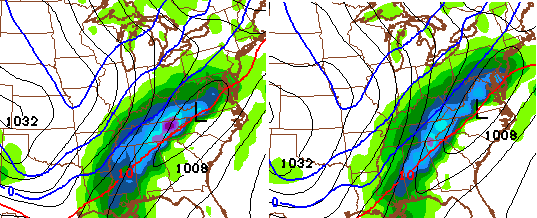
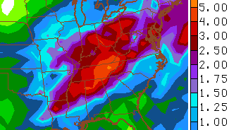
Heavy rain and wind will accompany a bigger system on Tuesday and early Wednesday. That one could cause some high water issues.
Another system tries to develop along another arctic boundary late Wednesday into Thursday. This one may take on much more of a wintry look…
Check out the blast of cold air coming behind that bad boy…

I would call those temperatures solidly below normal!
I’ve been trying to hit the fact that next week will feature a lot of precipitation. Our waterways are full and we have snow still to melt, so we will need to watch the high water potential. The latest numbers from the GFS…
 Have a great day and take care.

Chris, or anyone. How much of Precipitation is coming Wednesday night through Thursday?
*How much Precipitation , not How much of
Didn’t u say not to trust a rainy warm up?
hahaha…well said
Well said?
Me? The same person who has been talking about heavy rain for next week for several days now? I said don’t trust people telling you next week is spring. It’s not even close.
I remember you saying that at some point in my blog reading. I was hoping I imagined it. Lol
I think he mentioned something about it being a dirty warm up or something like that. If it was warm and rained not to trust it.
I don’t like this next week set up.yo yo temps and lot of moisture.
Hopefully we can get some severe weather.
march will be here Sunday, perfect time for spring and rain:)
Will all this precipitation fix the water shortage issue Clark County is under? Is the problem processing enough liquid water to fill the tower tanks back up?
Really concerned about the flooding potential for southeastern Ky next week..