Good Saturday, everyone. February is closing out on a frigid note and that comes as a shock to absolutely no one. This has been a legendary month of winter weather across the bluegrass state. What about the start of March? Things are looking wild as we have a TON of weather on the way over the next several days.
A series of storm systems will roll across the region starting Sunday and each of these will deliver a lot of different weather. Everything from freezing rain to rain to high water to thunder to snow and sleet will all be possible in the coming days.
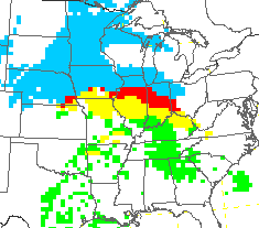
We start to get the first system to throw precipitation our way later tonight and early Sunday. This will be in the form of a mix of freezing rain and rain with some snow possible in the north. All that may change to plain rain during the day Sunday, but go back to a mix or some light snow Sunday night and early Monday. That’s when temps drop again behind a front that sags southward through the region.
That front then slowly lifts to the north as a warm front on Tuesday. Overrunning moisture from this may be in the form of freezing rain to start the day. Here’s the NAM…
The GFS also shows the freezing rain…
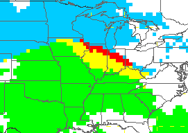
Temps will BRIEFLY spike late Tuesday into early Wednesday. That’s when heavy rain and some thunderstorms could blossom across the region. It’s during this time we will have to keep watch on our waterways for the potential of high water issues developing.
A strong cold front will then swing in here on Wednesday as a wave of low pressure develops along it…
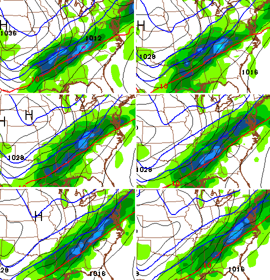
That scenario has been showing up with each and every run of the GFS in recent days. Most of the other forecast models have something similar. Here’s where the GFS spits out winter precipitation…

Told ya there were a lot of possibilities on the table for next week. 😉 Let’s sit back and see how many of them come to pass.
I have a busy day of events on tap, but will try to update at some point. I will be tweeting thoughts as needed.
Enjoy your Saturday and take care.

Long time follower, first time commenter, from Gallia County in the Buckeye state. I have a couple questions for you CB. First off, when are you coming back to WSAZ? Soon I hope! Secondly, if you’re not coming back, when are you starting your Presidential run? With the following you have you’d be a shoo-in. Bailey For President 2016 has a nice ring to it 🙂
Lol, Sounds good to me! Bailey for President!
March is so overrated 😉
Unfortunately, with an overrunning situation, a great deal of that could fall as freezing rain. Old Man Winter can keep that stuff in his bag of tricks.
http://www.tropicaltidbits.com/analysis/models/gem/2015022800/gem_mslp_pcpn_frzn_us_22.png
Did someone say ice..
Like the old saying,” If you don’t like the weather in Kentucky, wait a few minutes and it will change!”
Thanks Chris. This time of year always seems to be wicked. I guess that comes with March. It’s like old man Winter and Sally Spring are in a boxing match and Spring is taking a few blows! Have a great Saturday everyone and GO CATS!!!!! Beat Arkansas!!
Here’s what the GFS is thinking for next Wed. night. Yes it will change before then, but just an interesting look. http://wxcaster4.com/gfs/CONUS2_GFS0P5_SFC_ACCUM-SNOW_120HR.gif
INTERESTING MAP!!! Still have plenty of snow here and still much of county without water. Been a week since water went off for some people. If map holds out may see several more inches of snow.
Geez. My head hurts.
If all these storms come from the southwest, they have rain and a lot of it. The only snow will be the usual backside flurries. That has been the dominate theme all season except for the Feb. 16 storm.
It’ll take more than 1 event to reverse a 15 year pattern. Mostly rain with some minor wrap around flurries.
My thoughts exactly. The last two weeks have much below normal temp wise with decent snow of 7 inches in my area. A lot of people will remember this Winter as being very bad, because of the last 2 weeks. On the whole though, it was a pretty weak Winter. It was non existent for December, January and half of Feb. My location still has only received half the normal season snowfall we are at about 16 inches, when 30 or 31 is normal. Every storm except one has followed the same pattern come g from southwest with rain, backside flurries and 2 day dry cold. The only exception was Feb 16.
Also I think the storm last Saturday was the most disappointing. It had the most potential and the least to show for it. All time record cold in front of it only to produce a deluge of rain in less than 24 hours, a 55 degree temp rise at my place in under 24 hours. That was pretty amazing but very depressing for a snow lover.
Wow, somebody wake up on the wrong side of the bed? Just how much snow will it take for you to consider the “Dome” busted? Fact is, central and south KY are going to have very slim winters snow-wise. Enjoy what the past two weeks have brought and ignore what “normal” is. Rodger in Dodger!
It would take a double digit snowfall to bust the dome at my home. One which we haven’t received in 19 years. Prior to that we had 6 really big double digit snows in 78, 85, 87, 93, 94 and 96. In a period of 18 years. Being a Winter/snow lover I can give you the exact months and dates of each of those snows. Since 96 not one. The point I was trying to make is not everywhere broke the dome and the last two weeks doesn’t define this Winter. I did enjoy the 7 inches I got but it was the exception and not the rule as long as the southwest wind dominates. By the way anyone notice the snow from Texas to Missouri it will be rain when it gets here thanks to our old enemy the sw wind.
This is correct. I mean our dome here in Berea was shattered to bits with that 14″ storm, but everything since then has been below or way below forecast. This was great because the other weekend because we didn’t get hardly any of the ice or snow from that system, just 97% rain. On the other hand, it makes me wonder if the dome has returned T2 style.
Going into spring, I’m okay with that scenario, as that same dome also kept the severe storms and tornadoes out of the city during that time period. All things being equal. I’d rather have it than not.
No 15 year pattern luckily here in Morgan County. My oldest is almost 17 and I know that some years when he was younger we had decent snow. He built a few snow men and a couple years our pond froze over and had deeper snow on it. Have many pictures of it. My husband could walk on the pond a few of those years. So we have been lucky I guess.
I have lived here my whole life. Some will say that this winter was not that bad but I disagree. I remember missing a lot of school in the 90’s. Mostly not that snowy. Would miss no school through December. Then mid-late January or early February we would get a big one. After that melted it was generally back to normal. Some of those stuck around due to a few weeks of really cold and sometimes power outages. Seems to follow this pretty well. Even in the early 2000’s it was like this. It wasn’t like we would get big snow after big snow. Ice was an issue as well though. And that lead to power issues. And really, it seems the overall average for the last 100 years or so (whatever the average comes from) is not that high.
Another thing that gets me is that my family has lived here their whole life as well. Older family since the 30’s-40’s-50’s and they say that big snow is not the norm. My mother in law who lived here until the late 70’s and then moved back in the late 80’s seems to say the same.
Is the forecast high today 32 or 21?
From the live site just now…
7 day including today
http://gray.ftp.clickability.com/wkytwebftp/NEW7DAY-HD600_WEB.jpg
Text forecast from Weather page on live site just now
“Today’s Forecast High: 32 ”
I remember seeing the 21 number for the last couple days, so I’m gonna guess that the forecast high from the weather page may be a quick edit from this morning.
Also, I caught that the Mike Linden weather page forecast exceeds the 7 day and says “low 60s on Wednesday”. I don’t mind the warmer weather but man, 60s is gonna feel like 90s when you’ve acclimated to record cold temps. Prepare for sweating when you shouldn’t be.
This is an issue of the day updating and not the forecast part. I have seen this happen several times before. The 21 high was for Friday. Just drop that and shift the days over. Sunday is the 40/32. At least this has been my experience with this.
Calling for 2-4 inches of snow here in Jackson Ohio tonight thru tomorrow morning before switching to freezing rain in the morning then all rain later on then back to snow tomorrow night.
I see that the weather.com site is calling for rain Sunday here. And then Sunday night a low of around 30 with 70% chance of precip. Wonder if we get some icing overnight or it just mixes.
I know the school here has the ACT test on Tuesday. Seems that they will make that but Monday might be another day off. If temp forecasts are correct and it rains and changes to snow overnight and drops to 29 (that is the low weather.com is showing for early Monday) and stays below freezing through 11 like is showing I could see schools having to cancel again. Wondering if they will still have to give the ACT at that point? Would not like it for the students if they return to school Tuesday and immediately have to test.
Wow, was just checking around the net while eating and thought I would look up annual snowfall numbers. This is what I found:
Annual Snowfall:
Kentucky: 8.8 inches
My area: 8.5 inches
Louisville: 12.2 inches
Hazard: 13 inches
And saw this: “The Kansas City 100 year average is 20.1” of snow during a typical snow season which is from October to April.”
Overall I would have figured some of those numbers would have been a little higher.
43 here in Carrie of knott co. Feels warmer.
Fwiw the latest Euro..Shifted way south than previous run..
http://i.imgur.com/XiQeGxP.png
Lol…you should NOT have posted that map.
All the doughnut hole conspiriters are going to LOVE this!
Long live the dome, haha
That looks normal for my part of WV.
Quite the temp spread today.. 20s in the north, mid 40s across the south.
The latest hazardous weather outlook from the NWS mentions “Accumulating Snow Possible” for late Wednesday into Wednesday night.
For what area?
The NWS in Louisville has accumulating snow possible for its coverage area. I do not know about any of the other regions.
That’s correct. NWS Louisville has the statement out for all of its coverage area for now.
After the extreme cold we have had recently, this 40 degree day felt like a heat wave. It felt so warm i even went out and washed my car this afternoon.
Ky. has had some its biggest snows in March. Jst sayin…
Just for fun, I took the 2010/11 through 2014/2015 and totaled all the snow that fell during those 5 years and averaged it out for the city of Lexington and the average was right at 20 inches.
There is a lot of snow to the north and west.Wondering if any will fall in eastern Ky tonight.Maybe it will stay north.I still have big piles of frozen snow that is slowly melting.I can wait awhile for more snow.I am tired of shoveling.
NWS is Jackson is saying sleet and freezing rain possible overnight and in the AM
I sure hope not.But if so maybe this will be the last of it till next winter…
Temp up to 33 in frankfort, looking like a nasty cold rain coming in, uggggg
That Wednesday/Thursday system looks good. At least from my novice reading of the latest model. I do realize however it is still 4 nights away and in weather speak, that is an eternity. Nevertheless I concur it will be a cold rainy week! Which is unfortunate, I prefer the cold to be accompanied by snow. It may in fact be Spring very soon; at least when the 5 inches of snow still in my yard melts.