Good Sunday, everyone. March is off and running with a wintry mix and light rain across our part of the world. This is a sign of things to come for the week ahead as we have a little of everything on the way. This is all courtesy of a wild temperature ride on the way for the first week of March.
Our morning wintry mix and snow may cause some travel issues across the northern parts of the state. That’s where temps will struggle to get into the low and mid 30s today. Areas across the south and west will hit the 40s with a few showers around.
Those numbers will come down for Monday as a cold front swings through here. Here are the highs…
That could be accompanied by some early day snowflakes.
The next storm system cranks up to our west later Tuesday and that brings us a better chance for showers and some thunder. The models continue to come in with lower rainfall numbers, but some local high water issues would be possible late Tuesday into early Wednesday.
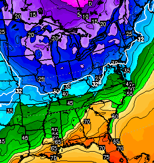
That’s also the period we are likely to see a nice temp spike and an even bigger temperature crash. Check this out…
That would be your standard 30-40 degree temperature drop as an arctic front sweeps through here. That front is likely to have another wave of low pressure along it and that could produce a swath of decent winter weather somewhere across our region. The European Model…
That’s a setup to watch closely in the coming days.
High temps behind that system by Thursday are super cold for early March…
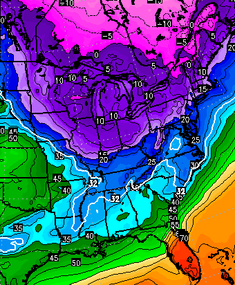
Highs of 30 degrees below normal? That’s impressive.
I will have updates later today. Until then, let’s track…

I-71/I-75 at I-275
Near Covington

I-275 at Mineola Pike
Near Covington

I-275 approaching KY 20/Airport
Near Covington

Take care.

Snow lovers, (including me) you want the models to shift south so that when we come withing 24-36 hours of the event, the great Northwest shift happens and slides it into our area like last time. Lets reach 30 inches for this season in Lexington!
Let’s not. Not being able to leave the house for several days was enough!
Plenty of spring and summer to come. It is still winter. Let it snow.
Believe the Euro is gonna nail this one..8-12 of heavy wet snow…Yippee
Where for snow? Will it end up rain after our warm up?
Watched last night as snow on radar moved along the Ohio River but stayed on the Northside, typical. And I have awoken to yet another???? 33 degree rain. The overall Winter pattern is the same, we got very lucky one time but it is gonna be the same old cold rain flurry action till it’s over shortly.
morning blog!!
Freezing rain along the Ohio River county’s they been stuck at 30-32 all morning long.
Plain old rain in CVG at 11am.
First day of meteorological spring is today. Would love to see some average highs which are supposed to be in the 50s right now. I guess the cold and below normal highs will end one of these days.
With all due respect, I’m tired of snow this season. I haven’t seen the ground in my neighborhood for a good two weeks.
Can we get some 30° below average temperatures in the middle of Summer?
Good Lord I hope not average high temp in the middle of summer is around 87 degrees take 30 away from that and upper 50’s for highs in August!?! I would be a very very very unhappy camper.
I remember 50s in June in 2003 or 2004 I think.
Amen. I’d be one incredibly unhappy camper if my summer highs were in the 50’s and 60’s. UGH! That’s not even warm enough to go swimming.
I would live 50’s and 60’s in July and August. I can do without 80’s and 90’s and worst of all our humidity.
Rodger believes the Wed “event” will be the last real chance for winter precip this season. Should get into a warming period next weekend. Wed event could be winter thumper for someone. He’s guessing north of KY. Rodger in Dodger!
Seems the forecasts for my area have changed a little. NWS Jackson says 90% chance of precipitation with new snow half and inch possible. 36 degrees and rain here right now. With a lot of snow still on the ground and the soaked roads could get very slick tonight if temps can drop to 30 which is forecast. Snow on the sides of my road (and I am sure other side roads) is keeping more water in the road than usual. Supposed to hit 45 today though so things might not get to bad.
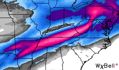
New NAM model showing a huge snow for MUCH of KY!!
Have a link to it Rodger?
Euro nails all of Ky..Anyone want too see the map..lol
http://i.imgur.com/fwviip0.png
Here’s a better one..
http://i.imgur.com/lRhywcl.png
Now that would be nice! One last blast — and then back to school on Monday.
I was just getting ready to ask about what the 12z models were showing this afternoon for late Wednesday. And just like that…BAM! 2 posts within a few minutes with model updates. I love this blog not only bc of Chris but bc of you awesome weather weenies that track the model trends just as close as I do!
Can’t wait to hear what Chris has to say on future updates later today.
I hope that pans out. But remember we are 4 days away. When all is said and done that area of heavy snow will be from St Louis to Pittsburgh. South of the Ohio River will be 34 degree rain. Past trends and the mighty southwest wind.
Bad being in the Bull’s eye this early..Hopefully it stay’s put..
Anyone know what the GFS is showing?