Good Sunday evening, folks. We have a very interesting week of weather ahead of us. It’s a period that looks increasingly likely to throw a winter storm in our direction. Wednesday and Thursday have the potential to be very wintry around here.
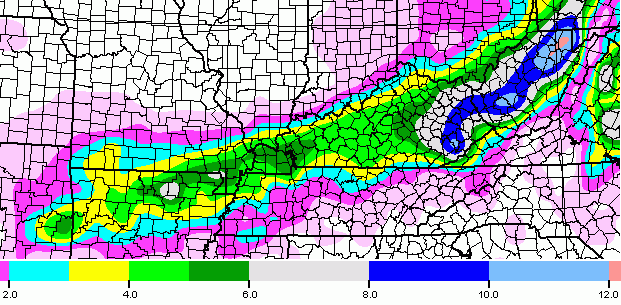
I’ve been highlighting this threat for a while, and the models are now beginning to settle in on the potential. The European Model from earlier today gave a nice smackdown sleetstorm and snowstorm to much of our region. The NAM only goes out through Wednesday night, but is also going strongly in that direction…
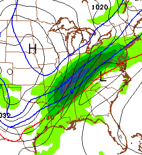
Now THAT is one heck of a look! A very slow moving arctic boundary with waves of low pressure riding along it could produce a ton of precipitation.
The GFS goes back and forth with what it wants to do. It is probably the moodiest model I’ve ever seen. The late afternoon run is picking back up on the potential and shows this for the pure snowfall…
Again, the GFS is still trying to figure out the setup and that map does not include the sleet potential. As always, don’t take exact amounts and placement to heart from 3 days out.
The folks at the Weather Prediction Center are beginning to come to gripes with the potential for this system to develop. Here’s where they are showing the potential for 4″ or more of snow during the daylight hours Wednesday…
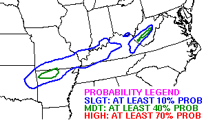
I’m not sure why the lines are so disconnected, but whatever.
Let’s what the overnight model runs bring.
Between now and then… watch for some icy roads later tonight and early Monday as temps drop into the 20s. Some areas of freezing drizzle and light snow will try to develop during this time.
Tuesday into Tuesday night will see temps spike briefly. That will bring the potential for heavy rain producing showers and some rumbles of thunder.
See you back here for a full update late tonight. Take care.

I would love one more shot of ssnow around here. Don’t get me wrong, as a teacher I do not want to be at school again until June 13! We are a snow loving family, and some good wet snow would be great fun. I want to have the chance to build one good snowman this year! :o)
So if this snow truly happens, when is it expected to start? Wednesday day, or Wednesday night?
Bring on the snow!
It is all about timing and where you live in Joe.
Gotcha, I live in ashland!
I can see it now, a flood, the 6 inches of snow to cap it off.
OLD SCHOOL circa 1987!!!! who remembers that SPRING SNOWSTORM???
I do Rolo. Lots of snow here in NEKY. Was that end of March and first of April?
I think this snow was around April 3 1987. I’m too young to remember much of 1987, but recall the 1987 snow date happens to be exactly 13 years after the infamous April 3 1974 tornadoes. On April 3 1987, higher elevations of TN, KY, WV, reportedly had feet of snow. Parts of northern Alabama had up to nine inches; even Birmingham had their latest measurable snow on record.
March 7-8, 1995
Anyone remember that date? I don’t, but it’s supossed to mirror this mid-week Storm
Anyone?
I looked it up, found nothing?
It was March 1993. I’ll never forget it.
I haven’t heard that I thought you just meant the big snow storm in March. I know we had a blizzard in March 1993.
Am I right that the NAM begins running within the next half hour or so?
Yes it’s running now
Needing updates! Lol
Same here prelude! Let us know what it looks like
There’s a pretty fine line separating sleet from freezing rain. What are the chances of the sleetstorm becoming an ice storm?
What are the chances this trends north and misses us in eastern ky?
Good chance as the NW trend will indeed play a part.
Hope it misses us completely with the heavy snow. Not recovered from losing an entire weeks pay from the last snowstorm. Hard to pay the bills with no money. Unless someone us volunteering to pay the for me.
I am on the opposite side of you. When I see the white stuff I see the green stuff.
NAM says BAM!!
Link?
Hope it misses us completely with the heavy snow. Not recovered from losing an entire weeks pay from the last snowstorm. Hard to pay the bills with no money. Unless someone us volunteering to pay the for me.
0Z NAM, major hit for eastern Ky
So eastern KY is still in the game for snow?
Western Ky up to Lex. looks to get crushed..Looks like 1.50 of precip..Apps says that is a lot of moisture.
Rutt Row… NAM in serious snow storm mode, epseailly EKY
How’s about a link please?
http://coolwx.com/cgi-bin/getptype.cgi?region=us&model=nam&run=00&fhr=99&field=ptype This is the link to a loop of the nam
That is last night’s loop
I think its the latest because it starts out on Monday
No its starts on Sunday on that link you just posted. The new 00Z NAM has a totally different look.
Nam is preaching a 6-12 inch snowfall for pretty much the entire area.
Ha Ha! Look at Chris’s latest tweet!
When someone gives a model update about the incredible amount of wintry precip it’s showing and they don’t give a link, part of me dies inside. It’s like telling a kid they have to wait until after they’ve had their dinner to have dessert. Or, something like that
lol me too
http://weather.unisys.com/nam/nam.php?plot=pres&inv=0&t=60
Thanks! Can you access the snowfall accumulation maps there too?
Sorry that is not the link I meant to give you. Will try again. WW
Ok, thanks!
Cincinnati Station just saying 50s and Thunderstorms Tuesday with over 1 inch of rainfall and flooding.
Let’s the tracking begin 😉
Why is it that a station just uses the RPM Model?
0Z GFS rolling now…
Any idea what it’s showing yet?
Mostly sleet in SE KY ?
I 64 CORRIDOR NORTH NORTHWEST SWEST best shot at 6 plus inches snow
could see a lot more, but SE/S bee sleet etc long time..
Who has the most recent link.
Snowfall maps
http://wxcaster.com/models_main.htm
We’re still a long way out. This thing could end up missing us all with the northwest trend… But the latest GFS is not near as north as the NAM. Hoping east ky will get another big one!
Can’t take much more of the stress……….back & forth models…..What has the overall trend been of this mid week storm?
Just ONE more big one! Biting at the bit, again. Lol, this Is like waiting to open up a Christmas present
March 21-22-23, 1968
Predicted rain.
Memphis 17+ inches
NAM is still too far north, imho