Good Monday afternoon, gang. A significant winter storm is likely to hit the bluegrass state Wednesday into Thursday. This could bring everything from flooding rains to heavy snow and sleet accumulations to our entire region.
I have no changes to the evolution of this expansive system. Heavy rain is likely ahead of an arctic front that sweeps in early Wednesday. Rainfall of 1″-2″ in a short amount of time will be possible and that would be enough to cause some flooding issues.
One thing working to help reduce the flooding risk is the arctic air surging in. That could help freeze some of the runoff, allowing our waterways a better chance to handle the rain. Still, be on guard!
The arctic front then slowly works across the state as waves of low pressure develop along it. There really aren’t going to be any trends to look for in this type a setup. The infamous “northwest trend” isn’t really applicable to this type a storm system.
This has the look of a significant snowstorm and sleetstorm for our region. The NAM (along with the European) continues to lead the way in forecasting both…
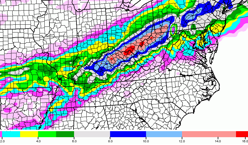
The GFS has finally come around to something similar…
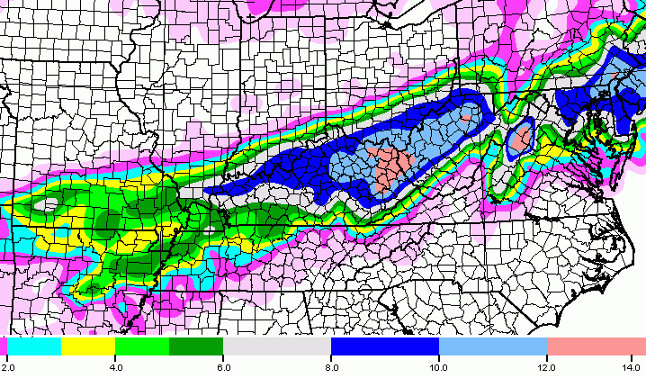
The Weather Prediction Center continues to increase the risk for significant snow totals…
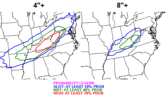
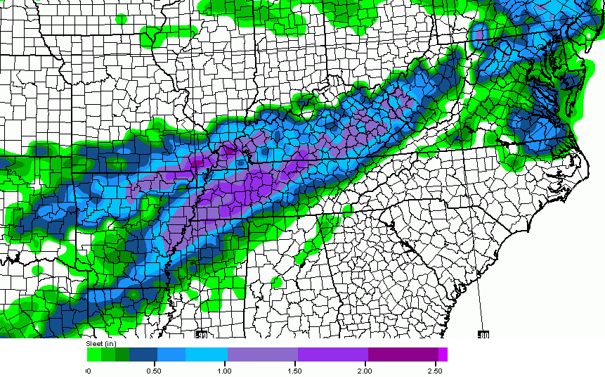
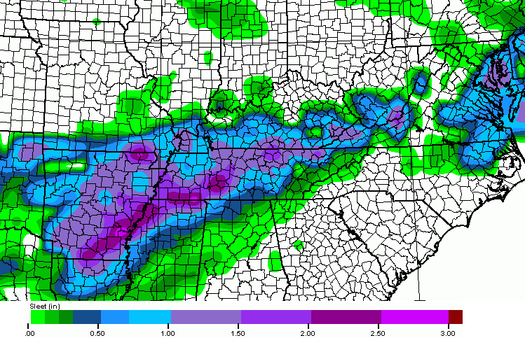
As you can see, significant amounts of snow and sleet are likely from Wednesday through the first half of Thursday. All of that may be falling on top of high water from the previous rains. With temps dropping into the teens from west to east late Wednesday… a significant ice up is likely underneath whatever snow and sleet falls where you live.
Temps on Thursday may not get out of the teens for highs with Friday morning lows possibly heading toward zero or below.
This has the potential to be a HIGH IMPACT winter storm that could cause more issues than what we had a few weeks ago.
I will have the latest on this system on WKYT-TV starting at 4pm and have another update on here later this evening.
Take care.

This is insane.
Just say NO to snow!!!! enough is enough already!!!
Goodbye milk & bread.
BIG difference in this one is the temps following the storm …. Saturday will be pushing 50 degrees, not like 2 weeks ago when it wouldn’t even get close to 30 for a week.
Can anyone tell me what it is looking like for East TN with this next snow storm? Please anyone!!!!!!!!!!!
Look at the maps.
Jeff that comment want needed.
Wasn’t needed
Barb,
Just getting ahead of the game here. From the looks of the map you are in the 12 inch range, does that work for you, lol.
You know they are messing with you out of fun and not being mean 🙂
First of all I’m not Mae. I just get tired of bullies on here
I’m not bullying anyone. If anyone thinks a simple “look at the maps” comment is bullying and trollish behavior, then I’m not the one with a problem. 😉
I’m used to people spreading false comments about me all the time.
Perhaps not the best response 😉
Blog hug……. Okay 🙂
Not the best response? It was actually right on.
I have to second this. When there is a map all you have to do is find your county and voila! You know what range you fall in! It really is quite simple.
Now, sometimes people don’t post maps and that’s frustrating.
But in this case, look at TN there on the map and find your county. Not too difficult! Carry on….
Barb you just got to not pay attention to them there like kids maybe they are kids I don’t know but I have learn the hard way you can’t comment on the blog if you don’t just over look them I know it’s sad that you can’t get on here and talk with other bloggers like we used to in the early years of the blog I’m with you I wish Chris would get on here rid the blog of a lot of these people but I guess that wo be hard to do
Some people just have thin skin and a persecution complex. You can get on here and say whatever you like. Your “kid” comment is out of line.
Stop it! No soup for anybody at this rate!
I’m going to Meijer soon to buy some soup. Try and stop me! 😛 😉
🙂
Someone metioned soup?? 🙂
Jeff I didn’t mean anything about the kid comment just that I think some on here are young really didn’t mesn anything bad
I don’t think they were being mean. I just think that everyone gets tired of people being too lazy to find their county on a map and read the key for the corresponding color. No matter how detailed a meteorologist gets in their forecast, there are always a ton of people wanting a personalized breakdown, specific almost to their exact street. It just doesn’t work that way and they don’t have time to answer 100 questions like “How much snow will I get beside my birdfeeder at 2457 Oak Dr??” or “I have a doctor’s appt at 3 on Thursday, how will the roads be then?” Even when people so dramatically say “please help” or use 50 exclamation or question marks.
LIKE this!
LIKE…LIKE
Please keep in mind that some people cant see the maps if they are on a restricted computer… sometimes it takes a while to load the maps on an older phone. This site has been a blessing for so many people that have no weather knowledge. For all of the “gurus” that frequent this blog, we are grateful, just please keep in mind that we may not know as much as you that’s why we are coming here for your expertise, please be patient and know that by answering a seemingly simple question to you, you may just save someone’s life.
*LIKE*
*LIKE*
LIKE*
Yes!!!!!
Go away, troll.
Who are you calling names. Hopefully Chris will not put up with bullies much longer
Barb i was calling jeff a troll. You told him to quit bullying people. He always does.
Let me know when you want to stop lying and falsely accusing me.
Barb called you a bully as did others. So I’m not sure how I’m lying if others are accusing you of the same thing I’m “lying” about. Nice try though.
Ummm, what is Jeff doing that is bullying? Look up your own county, folks. Geez, Chris put four maps in this post to help you find possible accumulationin your backyard.
Wow, we have sunk to the level of calling someone a bully for commenting on a post with no vulgar words on their laptop?
SHAAK how about you stop it with the blatant lies and obsession with me.
Can someone tell me where I might find the weather forecast for Kentuckiana middle part of this week?
If you mean closer to the Louisville area, WAVE 3 would be good I think.
Hi troll.
Hamlin. All you had to do was answer Mae’s question, otherwise you should have kept your arrogant mouth shut and not responded at all, (the better option for you). There’s a reason people comment on you. You do bully people whose comments you don’t feel meet your superior high standards.
Mike I am not arrogant nor do I bully anyone. Quit spouting lies like SHAAK. Follow your own advice and shut up.
Jeffrey, I think arrogant jerk better defines your wonderful personality. Sorry for leaving that off.
As of now more of a sleet storm with some minor snow accumlations for east Tennessee
Here is my question for the weather gurus. If it rains a lot before the snow hits won’t that hurt the snow when it comes to sticking? Will the snow just fall on the wet ground and melt? Seems like I’ve seen this happen in the past. Or at least it will have to get to freezing before the snow sticks.. Right? Or am I wrong lol
Heavy snow will overcome that issue intensity rates look pretty decent
You might be right 🙁 Think sleet! 🙂
Here we go again.Not what I wanted to see but thank you for the heads up ahead of time Chris.At least I know to get prepared to be snowed in for a few days.
I am very concerned with this because we already have way to much water on the ground.If this happens we will likely see downed trees and power outages.This is kind of like adding insult to injury.
Will the snow on the ground from the last big system have any affect on this storm?
The impact would be lower ground areas near creeks and streams due to flood chances. Rain should wash most snow away, so no snow pack impact when the snow starts this time.
Will this be like the storm we had last Sunday Monday
Amount wise very possible this will be more of the heavy wet snow in could get more powdery as temp falls but i think primarily a wet snow for this event
Also more sleet will be involved.
Question could be is the sleet/snow going to be the boundary type in relation to the system path, or more like waves of sleet and snow. Perhaps a combo of both….
It’s possible but it looks like the atmosphere will cool sufficiently at all layers for a primary snow event. Sleet initially will be involved for many but should transition fairly quickly to snow.
On a side note, last week was supposed to be the end of winter and this week the beginning of the spring warm-up. That is per CB’s arch nemesis, mid last week 😉 And the other channel too I believe.
Flood Watch for Carter and Boyd in Ky, from Tuesday evening through Thursday morning. Not forecasting accumulations of snow yet.
NWS in Louisville will have a conference call today 2:30 pm. Discuss the flood potential for tomorrow and the snow for Wednesday.
SE KY will either be part of the sweet spot or miss out mostly all together
If the path plays out like CB thinks, the NW shift issue might not be a factor.
Bet on the 2nd option
Just for fun.
http://m.youtube.com/watch?v=X6pg69ryG-Q
Thank you Chris ! As I read this my mind goes back a few years. I’m sure it was in March or April in the late 199? , it was around 7or 8 o’clock in the morning. I was on my way to Hazard from Whitesburg for a Dr appt., it was absolutely pouring the rain you couldn’t hardly see where you were driving and the temps were mild. By the time I got there ( about 45 min.) it was changing into sleet and snow. I was only in threre about 45 min because the staff knew it was getting bad. By the time I got out snow was already covering the roads. Salt trucks and scrapers already working hard but the snow was coming down so fast and hard they couldn’t do anything with it. It took a while to get back to Whitesburg but I made it. The temps were mild again two or three days after the snow. Just like this scenario!
Thank God I didn’t have Breast Cancer!!!!
1998 event was heavy rain during the day that changed over in the early evening to mix, sleet and then unrelenting snow. Not saying that is the same here. I am putting my horse bet on Mr. Sleeter winning, since I want him to win 🙂
I was thinking 60% sleet and 40% snow, but was expecting warm air to be a bigger player. If the cold air settles in more, it could get interesting and Mr. Sleeter would lose.
Updating grocery list: bread (15 loaves), milk (16 gallons)
And one football 😉
Lucy still hasn’t paid her hospital bill from the beating the last storm gave her. 😀
Hahaha!!!! That is if u can find it!!!! Might as well laugh about huh?
getting really tired of milk sandwiches!
good one
I won’t discount the southwest wind in my part of WV it always wins out. The southwest wind will keep rain going till the moisture is gone before the cold arrives, seen it too many times here.
well I will give it another 24 hours. If it is still on this time tomorrow I will head to the store
I wonder how many gallons of milk have gone bad sitting in home refrigerators because of …this forecast=snow…brain..=..mil..bread..lol really who drinks that much milk..lol..lol..
Milk not mil
My 17 year old drinks about a gallon every 2-3 days.
He’s hoping for more snow and less school.
I must admit, I’m on board for that.
My 3 kids use about 2-3 gallons a DAY when school is out. Sometimes more if they are really eating the cereal. And we need milk. Usually get 10-12 gallon at a time. I have had people ask it the weather was supposed to turn bad or something when they saw all the milk we had in the cart.
Just wanted to check this out after I say the story linked below –
http://www.climatedepot.com/2015/02/28/noaa-2185-cold-records-broken-or-tied-in-past-week-1913-low-min-records-broken-272-tied-in-7-days/
Chris B – November 2014
Last winter I made a bold prediction that Lexington would set a record low for the first time since February 1996. We did just that. What’s the bold prediction for this winter? This is the winter we finally get the “big one.” We haven’t had a widespread double digit snowstorm since the infamous “dusting” of February 1998. The pattern for this winter suggests that streak comes to a snowy end
^saw
Better go get your milk and bread now! Looks like this one is going to be a bad one for a lot of people. Thanks Chris. Will be anxiously awaiting your updates as this thing gets closer. Have a great Monday afternoon all.
Where you been Coffee gal?
She has been with me out getting milk and coffee,love ya coffeelady.
I usually wait till after we get results to get my milk. I hate fighting the crowds and there being nothing to get so I go the next day when the shelves are restocked
Thanks Barb and prelude so good to know there is some good people still on here. They say that smart mouths are in every group!
Interesting that Micah Harris says 3-4 inches….hmmm
What will be crazy is the temps tomorrow will be 55-65 and the 24 hours later we could be seeing a snow event. Only in March
Typical March weather to be quite honest
My biggest nightmare is the April 2-5, 1987 snowstorm.
Sadly, we really do need milk. Now I’m going to look like one of *those* people who rush to the stores to buy B&M before a snowstorm. 🙁
Haha! Me too! I just really need groceries…sigh.
That’s OK! Free thinkers in this situation run out of milk 🙂
How many inches of snow will south central ky get
To early for forecast amounts give it tomorrow afternoon/evening time frame.
There now you see Hamlin, that’s a nice way to respond to someone asking a question on the blog. Good job Prelude. 🙂
Nice try at trolling me. So wrong, it’s funny.
Glad to see I’m not the only one who sees you for what you are.
If I am correct in what I am seeing on the maps, then where I live is going to get pounded. The snow in my front yard is still pretty deep in spots. I guess I should be looking at my roof and not the yard. I am a. snow lover but I have had my snow this year!!! I am looking forward to Spring!!! Enough said!!!
The good thing is that this weather won’t last much longer. 🙂
If this storm pans out for kentucky and it being first of the month, It will be a crazy mess in the grocery stores.. Thank goodness all i need is diet coke, tictacs and wine to survive for a few days 🙂
I have a liquor store just around the corner from my house, heh heh heh.
Now that’s a survivor kit! …and make sure my NetFlix is paid up!
So what time does the new nam and GFS models run today?
3pm for Nam around 4-4:30 for GFS
Thanks prelude.. Keep us updated on the runs!
Euro still holding serve..Pretty much the whole state get’s a googly moogly..
Apps could you post a link?
http://i.imgur.com/lc5Jog0.jpg
Sry for the paste job..kinda left some out..Get the idea though..Course all this will not be snow..
Thanks! Wow!
I just wanted to stop by and say that this weather stinks like the south end of a northbound mule.
Ok Rolo stop praying for the ol’ school winter storms. We’ve had enough. 🙂
As long as there are no power issues with this storm, there is plenty of bread making material at my house as well as milk and I am buying eggs today. Plenty of cold beer in the fridge, too. 😉 #prepared
Please tell me how many inches of snow central ky will get any body
BG is in 6″ for GFS 8″ for NAM , and 12″ for most recent euro model. I don’t know about all of SOKY.
Thank you so much so do you think we could get a foot of snow again
I’m not sure where you are in KY, but WKYT at Noon had Lexington at 11.1 inches as it’s early prediction on the map.
I live in hart county ky will we get a foot of snow
If I am looking at the right county, it looks like right now you’ll be in the 6-10 inch range. Seems that is around what was in that area on the news at Noon as well. Still not a bad haul!
Apps says Power ball numbers is 12,24,36,48,60..12powerball..he,he..joking..too early to tell atm..
I wonder when CB will make his first call for snowfall?
SNOW LOVERS REJOICE!!!
hope this holds out as the maps above. I thinks Louisville will receive more sleet than snow. Just the trends for our area IMO.
Going to be interesting to track to say the least.
Thanks for the updat CB! Oh and by telling someone to look at the map is not bullying, but a fact. The first thing I do when I see a shaded map with lots of color I find my county “Jefferson” look at the color over it and refer to the scale at the bottom of the map. So Jefferson county should receive anywhere from 4 to 12 inches depending on where you live in that county.
Southern Jefferson County absolutely mystifies me. Mike S in Valley Station will report 6 inches at his house and then you get other reports of 10 inches less than a mile from his home and that report is also coming from Valley Station.
So when is this going to happen any body
In late May I think.
Everyone give JacksonD a round of applause.. As it seems, he is desperately craving attention!
Probably Jeff Hamlin’s alias.
Someone is obsessed with me and with making false comments against me, lol.
On the Noon news, Micah, said around Noon Wednesday through Wednesday night. That’s just early runs though…
Chris: congrats on your profile in todays Lexington Herald-Leader. Looks like you might be working those long hours later this week at 27…
44 in Carrie of knott co. Still think the models are overplaying the arrival of cold air in seky. Been warmer than forecasted last week.
Cold air not suppose to arrive in your area till mid or late afternoon on Wednesday.
I figure it arriving later than that. This one is gonna be interesting for sure
I agree it is much harder to root out the warm air in se/ky and western wv than it is to blow out the cold air.
Well, another winter that the infamous Blowtorch boy whiffed on. Although blowtorch weather sounds good right now.
Nws in Jackson says not much to see here, rain to snow, but mainly rain
That would contradict what CB is saying. Let’s take a mental note and see how things pan out 🙂 I would side with CB thanks 🙂 I cut slack to all mets for the last event, since was uncharted territory due to conditions in place.
No they aren’t. Focused more on flooding, understandably, but also calling for moderate to heavy snow. They are just unsure of the amounts at this point in time.
They said 4 inches or more best chances northwest of Jackson, meaning the bulk of their coverage area is less than 4 inches. Now I understand that giving out snow totals at this time would be crazy, but yet by saying 4 inches or more nw of Jackson is a way of throwing out totals. Just saying
Thanks Chris! Can you post the watches and warning for us when they are issued. Here we go again!!!
Hoping the models continue trending toward a foot or more of snow in Frankfort.
Flood watches will be posted pretty much statewide. WSW will be posted for a huge chunk of Kentucky.
Has the new nam ran yet?
Or GFS?
The NAM is running right now.
Thanks Chris!
NAM is running now
Post a link for us a prelude!
Come someone post a link please? Thanks in advance.
Its still running will do my best to post link
Thanks again.
Here is the link to the web briefing from the National Weather Service at Jackson http://www.crh.noaa.gov/images/jkl/Headline_Images/20150302_briefingslides.pdf
A beautiful day that God has given us, the sun is shining brightly and we are surely blessed, but sounds like some of us are having cabin fever or winter blues. Bubba, did you mention soup?
45 deg now in London … way warmer than was predicted …. you can feel the sun is so much warmer now – spring is upon us folks … whatever happens Wed night/Thur won’t stay around long !!
Agreed
True that’s what awesome about March, but either way you slice it or dice it, this could be a real humdinger for alot of people. All day Thursday all day Friday the snow will not be going anywhere melting process should begin by the weekend. Temps could get to 0 for a low on Friday depending on how heavy the snowpack is.
Weather channel has 5-8 + more most of ky
NWS in Louisville just issued WSWatch for our area effective Wednesday morning through Thursday afternoon- GADS!
CB…if you see this……supposed to catch a flight out of Lex Wednesday am at 7:25. Any idea when the change over will occur from rain to frozen precipitation? Thanks! WW
Seem to recall that the switchover from rain is supposed to be closer to noon Wed, so you’ll probably be ok, but definitely keep an eye on everything.
S/SE KY mainly a rain/sleet event
I sure hope you’re right on that Rolo. Had all the snow I can stomach…
NAM says nothing to see ..go on home..clear away ..unless u live along the Ohio river..then u can hang around..
I knew it would trend north
I said that last night. CB does not think it will so I like the fact that it is setting up through central KY and points northward. I still think it will move further North. Trends are Trends!
Lol. Tim lives down in Tennessee. And it doesn’t affect him. He’s trying to stir the pot with disappointed kentucky snow lovers. Haha
Apps says what happen…lol..Its like it went poof.
There is no northwest shift with this.The question is where the arctic front sets up. I do believe central and north central Ky will get the brunt.
Can you post a link please.
I am hoping the NAM is out to lunch.
CB said the NW trend should not happen with this event, but Mother Nature might say she does what she wants- when she wants.
Let the model cherry picking commence! 🙂 😉
NAM moved north if I am reading that correctly?
NAM shifted the heaviest snow north by almost 100 miles, heaviest band running through South Central Indiana. Will be very interesting to see where the other models head.
The event is less than 48 out, so the models should have a decent estimate at this point. Models not agreeing at this point could create consternation among the met community.
I have two “fears”. One is a big heavy snow and the other is mainly a miss with big heavy salt.
I do not want either.
Something is gonna fall from Louisville to Lexington…
http://wxcaster4.com/nam/CONUS1_MESO-NAM212_SFC_ACCUM-SNOWFALL-KUCHERA_84HR.gif
But folks were supporting supporting it when it was similar to the GFS 😉
Not seeing the system shifting north as much as it is simply less snow and more heavy to the NE. This could be picking up some sleet impact and the higher elevations NE not having as much warm air impact.
Good thing we know the Nam is a horrible model..
18z NAM is trolling!
It will get itself back together on 00Z run.
Yeah most Mets are saying its out to lunch and moved way too north
Not so sure. Again, if it concurred with the GFS the NAM would not be questioned. It was treated as such earlier today. If the GFS concurs with a north shift later, would that mean it joined the NAM for the same lunch?
Odd, my early model comment was place in the wrong post a few minutes ago…
BTW, I do not know the model bias, but always interesting how information that fits what folks want is deemed the more credible 🙂
and that’s the bottom line, cause Stone Cold said so! lol
When does gfs run
4:30
As I said. Trends are trends. That is a snow map. Does not show the sleet potential. Going to be a sleet storm from the parkways to the river.
This. Folks might presume it is a system move to the north but is the actual stuff that is estimated to accumulate.
Or, it could be a shift to the north…. Dun dun duuuuuuun!
I am not a fan of the NAM. Hope the GFS produces a better model for us snow lovers. We are a little less than 48 hours from the start of the changeover. I hope the models can come to a consensus. Reminds me of my first wife with all this back and forth nonsense. Back then I just needed a strong southwesterly wind to blow her across the ocean.
Still continuing my snow dance!
I’m just here so I don’t get fined. 😉
nice one
at least this isn’t an issue of being flatter. 🙂
Yes. I think we’re all thankful for that.
Thanks for making me spew coffee all over my monitor
One thing is true the models have all trended some north. Not gonna be much to see in seky imo
Models over playing arrival of cold air. Warm air is hard to budge here
I agree 100%. Warn air will hang on till the bulk of the moisture is gone. Can anyone say backside flurries?
Lets see what the GFS says
What’s it looking like
REMEMBER: This last NAM was the 18z run. 00Z/12Z are generally considered the most accurate.
yes, the 18z is the off-run.
knee jerk reaction to one run of an 18z model, is not needed.
This is a complex storm.
Thanks! I honestly don’t know a thing about the models other than how to read snow totals by the color key (lol), so always good to have someone give us the heads up about these things 😉
We shall see…….. 🙂
Is this CB? CB normally posts as Chris Bailey.
No sorry, I live in Louisville. Just another Chris floating around 🙂
Just issue winter storm watch here far western, ky. There saying were in the path of 6-10 inches frame so were right smack in the middle of it. Up north across the Ohio river in Indiana there in 4-8 range.
What’s the gfs looking like?
Gfs is much further south than the NAM and still shows a monster storm for most of ky.
What does BG look like?
Could you post a link?
Gfs says the nam us on drugs, still has the storm
NWS in Louisville saying conservatively 4-8 inches. With 10-12 inches of snow possible in spots. Snowfall rates 1-2 inches per hour and thunder is possible.
Nam is out to lunch people!
Anyone have gfs map?
http://www.tropicaltidbits.com/analysis/models/gfs/2015030218/gfs_asnow_neus_14.png
Enjoy snow lovers
As usual the NWS in Charleston will be the last to get on board for a WSW for Boyd and Carter.
They always are. Everywhere around us has watches or warnings. They always wait till under 24 hours.
They remind me of someone picking the winner of the super bowl…..with two minutes to go in the fourth quarter. One of the many reasons I only follow Chris.
I dont even acknowledge their existence anymore. Kyweathercenter.com or bust here in Carter Co.
I guess the means re nam is no longer leading the way, lol
Folks like to cherry pick their models 😉
Just saw a report out of western WV that Boyd & Carter can expect 2.3 inches of precip. No mention of snow amounts except that snow is expected to be heavy. Waiting for the nowcast.
That’s fine. I can look out the window and now cast. Lol
I’m in greenup…wsaz kills me…alshon they did mention very heavy snow
http://wxcaster4.com/gfs/CONUS2_GFS0P5_SFC_ACCUM-SNOW_96HR.gif
Sliding northward
For seky anyway. Gonna be a big storm for 64 corridor
Looking at the temps I’m wondering if it will play a part of how much snow we actually get. If it doesn’t cool down I’m thinking it’s going to be all rain……thoughts?
Looks like a sleet fest to me..Threading the needle in Eastern Ky..May get more sleet than snow..Hard setup to forecast..
Seems sleet could be a total killer for a lot of folks. Hoping north Madison is one of them. I appreciate CB says the system would not shift north, but (so far) it seems that is somewhat the case.
Looks like I’ll be hitting the grocery after work.
When does the euro run.
I think later tonight?
Around 2-3 AM. It only runs twice a day whereas the NAM and GFS run four times a day.
All the usual suspects trying to downplay the storm. I guess they liked the taste of crow so much after the last storm that they’re working on getting another plate of it.
Yep. I notice CB’s arch nemesis this evening do that very thing- down playing and hoping he is correct. This is less than five days from when he said it was all over and this week would be the start of the spring warming.
Everyone saying they see sleet being a big factor and can’t see temps dropping that fast, isn’t that exactly what happened a few weeks back with the “dusting” that turned into 5+ inches for many of us? Tells were in the upper 40’s, low 50’s early that day and then plummeted. It does happen.