Good afternoon, folks. We have another major winter storm that is getting ready to pound the bluegrass state with significant amounts of sleet and snow. The closer we get to this system, the more impressive it’s looking and the greater the chance it turns into a “shutdown storm” for many.
The latest runs of the computer models are really amping up the moisture even more with this system and have a slower departure time on Thursday. With that in mind, here is a fresh call for snow and sleet…

Most of the accumulations start from northwest to southeast late Wednesday afternoon and then REALLY kick into high gear Wednesday night and Thursday.
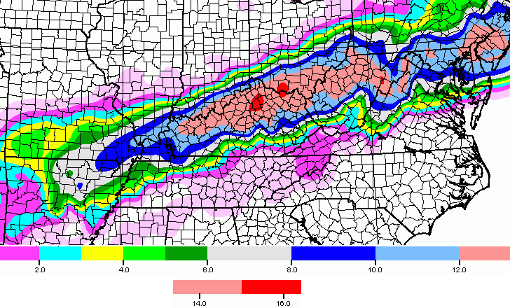
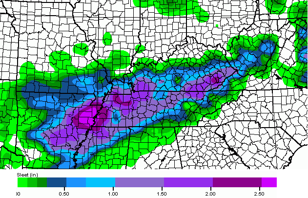
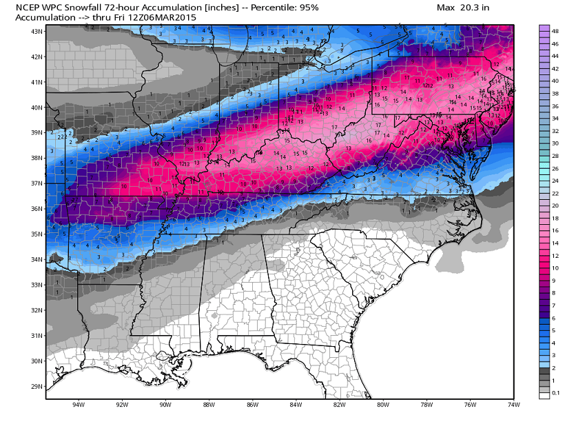
Significant amounts of sleet continue to look likely and that would cut down on the true snow totals. Areas that have less sleet can easily top a foot of snow before this wraps up on Thursday.
The lift with this is rather impressive and I wouldn’t be surprised to hear reports of thundersnow or thundersleet during the height of the storm.
I continue to like what the GFS is cooking for snow and sleet…
The latest “worst case scenario” from the Weather Prediction Center was issued before the latest amped up runs…
Again, snow totals where you live are directly tied to the amount of sleet that falls. The more sleet, the lower the totals. The less sleet… look out.
I will have the very latest on WKYT-TV starting at 4pm and will update things again later today. I strongly suspect Winter Storm Warnings will be issued shortly…


Take care.

Thanks for all u do Chris. Hopefully the weather will settle down son and u can get some rest. 🙂
I love it. Woodford county is in the center of the kill zone. One last hoorah for snow.
flood warnings out for SE KY
With a substantial snowpack still on the ground, could this effect anything for us in SEKY? What factors could increase the chance of the storm tracking further S and E
I would be more concerned with high water in our area
Creek areas watch out!
River flooding as well
All I can say is… Wow!!! Look-out central ky.
Thanks for the updates, Chris!
I believe the 5-10 is lil far south but that’s just imo. Rest looks pretty good
Better run and get your milk and bread. Lol! Go cats!!
This is the winter a lot of us needed. Now we can have a few warm ones in a row to help with the heating bills the last couple years.
Or I’ll take a nice cool summer to help with the air conditioning bills.
Looking like Laurel County will have a major sleet storm with some snow to top it all off. That could be pretty rough. Already been to the store and got rock salt. Let’s do this.
I usually wait till it happens I don’t have to fight the crowds that way and don’t buy more than I need.
I like SE KY’s odds, but only time will tell
Of?
The flow looks east NE, so not sure about that.
At least that is what the models show that CB posted.
Sleet for the win!
Seems the sleet should be in relation to the southern part of the system’s path for frozen precipitation. Generally the more south, the more sleet, unless the overall flow is sleet to snow as it progresses east NE.
Seems the north NE half of the state could be a lot more snow than sleet. I prefer more sleet since less of an overall issue to deal with.
Anyone else having issues with connecting this page?
its been acting wonky since 6 am at least
thanks
Yea, y’all have sizzled the circuits with posts about this impending storm! 😉
I get a message of server overload once in awhile.
Thanks Chris for keeping us updated even though I surely am NOT liking what is on the way.Another 10 to 12 days stuck on the hill it seems.
Move South closer to me and bobt 😉
thanks
Louisville and Southern IN look to get hit hard with snow especially if temps are low.
Looks like southern Indy is the top area of the system, so could miss the sweet spot with any further southern shift.
I have to make a work trip from Lexington to Nashville around 2pm on Thursday. Think I’ll make it? I’m pretty nervous about it at this point.
I think the roads will likely be closed.I wouldn’t count on being able to make that trip.
So since Boyd county is projected to get no sleet, does that mean we could possibly get a ton of snow?
That’s what I’m seeing. I know just enough to be dangerous though. Lol
When do the next models run?
C BG,
http://townersweatherpage.blogspot.com/p/weather-model-run-times.html
Click on this link….or copy and paste
This was very helpful…thanks a million!
Middleboro for the win if you’re over this winter and snow like I am. Very very happy we will have significantly less frozen precipitation than the rest of KY 🙂
I’m in Harlan County, and I agree with you. I still have several inches of snow in my yard… I don’t want, nor need, any more!
Same here and the ground is so soft it feels like walking on marshmallows.We do not need any more precipitation of any kind.
I wish the Scott County red color was related to our school colors, but its not! Talk about being in the bullseye!!
It really looks like we are going to get hit the hardest with the most snow and no sleet!
I will get my boat ready.
Is this all going to melt away over the weekend??
Maybe I just over read it but is this supposed to be a wet snow?
Yes
Depends on how much snow you get…don’t see temps getting into the 50’s with a large snow pack.
59 deg and still no rain in London …. not agreeing with the term shutdown for days ……. Friday giving sunny and temps in upper 30s, should hit 40, Saturday giving 50 …. won’t snow melt in those temps ?
The shutdown part is for north- central ky area. Us in southern ky will probably be on the lower end if the totals because the warm air will stay in place longer here, which is fine with me, heavy wet snow means no power here in the sticks,
Down in the southern part of the state…yes. The forecast for Lexington doesn’t hit 40s until Sunday. We’ll have a slower melt period until at least Sunday I would think.
mlb spring training games start today
been watching NYY and PHI on MLB.TV while waiting on the REDS to start.
60 here in Carrie of knott co. Rain gonna hold off till the eve could hit well into the 60s for highs.
I’ve seen this play out many times warm air will be slow to budge in seky
The flooding should be the weather headline this week. The talk of snow is only background noise to those living next to rivers in EKY.
Where’s Rolo? We need either a “OLD SKOOL COMIN’!” or a “nothing to see here folks, move along…” post. 🙂
I just noticed accuweather cancelled the winter storm warning for London.
Accuweather can’t only the NWS can
http://www.weather.gov/
I cant imagine there being enough cold air aloft to put down this much snow. I’m looking for mostly sleet out of this storm.
My many thanks to you, Chris, and to all the folks who make this blog the awesome place it is! I am now in need of some of that advice and wisdom!
My sister is driving from Somerset to Lexington tomorrow (Wed)- and is not a confident driver in poor driving conditions. Could someone PLEASE tell me what time you think that this will start getting “dicey” for the Lexington area. She has already called me twice today, asking for when she “needs to be in Lexington” tomorrow to avoid driving in the icy conditions.
MY MANY THANKS to any who can help with this estimate of time for it’s arrival in the Lexington area!! I do appreciate your help!!
Her best bet would be leave today. Lexington will see heavy rain tonight and tomorrow morning, changing to heavy winter precipitation.
I don’t know if this is accurate or not, and I’m not a weather expert my any stretch of the imagination, but I believe I saw on WKYT that the winter precip. could start in Lexington between noon and 1 p.m. Again, this is not etched in stone and easily could fluctuate.
And since it could fluctuate, I would go with Ashley’s advice…she should come today.
Ashley and Will, you are two examples of why this is such an awesome place! I truly, TRULY appreciate your input. She is someone very important to me and her safety is an priority to me. The more I was reading, the more I also wondered if she she leave for Lexington today. I love “weather” but am no where near the level of experience that many on here are in terms of reading models, etc. so seeking out the thoughts of others is important in many ways. When people such as yourselves take the time to respond to questions such as mine, it truly is a blessing! Thank you!
Not a problem. I hope she has a safe trip.
Euro anyone?
Runs at 130 doesn’t it?
Here on the ridge in greenup, it’s only 37 degrees
It’s fascinating the sharp cut off with this system. I honestly expect only 1 maybe 3 inches of snow where I live in Wayne County…which could be close to a foot difference to our neighbors in the Central & North. I guess it’s up for debate as to who’s “living right” with this one!
Bernard, Where are you getting your information? I know some of you guys on the southern end of the county struggle a little but where are getting 1-3 inches?
@Kentuckyweather: To make matters worse, below zero temps are likely Friday morning. Some areas could set all time March record lows. #kywx #WKYTRulesWinter
Euro holds pretty steady
Got a link?
http://i.imgur.com/KBMqiRy.jpg
latest Euro from Eurowx
Wow! Just wow! Central and North KY are in for a big one if that plays out….
Map so bright ya gotta wear shade’s..Huey Lewis shout out..
Love Huey Lewis! 🙂 I’m alright with that!
Wasn’t that Timbuk3?
Fun fact, that song was about an impending nuclear war.
Yeah…the first words out of my mouth were “Holy Crap!”
That’s obscene!
That is obscene. Can’t believe that 24 hours out and most models seemingly in some sort of agreement that there are no warnings out yet.
Holds pretty steady
Where are the Winter Storm Warnings?
Updated in the next couple of hours with the new AFD.
They will be out between 3-4 pm that’s a pretty much done deal.
Oh boy! The GFS has Scott County covered with a red blob for snow and no sleet. This could be worse than the first snowstorm!
Seems temperatures are not reaching the predicted highs.
63 here in knott co so they are warmer on this end of the state
With the slower departure maybe the Southeast will get in on the Goodies..Which may be a bad thing if you enjoy lights and heat..
no upgrade to warning, hmmm I feel BUST a coming
Rolocoaster starting on the down track! 🙂
A bust would IMO be a good thing, but not to the folks that want a big snow.
he has actually stand pat so far
NWS is having a conference call at 3pm they will be issuing WSW after conference call with local media and school systems.
is that Louisville?
Looks like it
Thank God, now will our friends quit the crying about how they never get snow? This, despite, getting hammered two weeks ago with the rest of us. Move down here to se KY where once again, nothing. So when CB mentions a state wide storm, I’m scratching my head trying to figure out when 2 inches of snow and an inch of sleet equaled a shut down event.
We have been annexed out of the state 🙁
CB’s mets counterparts from other stations (especially one in particular) continue to downplay the expected event this week. CB’s arch nemesis once again has less of snow on the map. That did not work too well two weeks ago and he ended up upgrading on the day the event was taking place.
Sad stuff.
Arch nemesis?
Bill Meck
aka The Voice of Reason
Ok. I had no idea. Thanks.
It’s going down folk’s..Good time to bring out Sam again..enjoy
http://www.youtube.com/watch?v=oPnrAEK1KnQ
OH! OHHHHH!
Or maybe…
SNOW! SNOWWWW!
Curious why the other two stations in town are predicting considerably less snow?
Hmm.
CG
this going be a MODEL bust, not anybodys fault, the cold air will lag back..
Hold steady rolo lol…you never back down…I’ll give you that
…. Rolocoaster’s are anything but steady. In this case though, I ma rooting for the down part of the track 🙂
Well this certain ride seems to be pretty straight 🙂
Oh no! Don’t say it will happen again! Go to sleep expecting a bunch of snow and wake up to cold drizzle of rain.
Lucy, where are you located? Has your temp reached the forecasted high?
This baby is not busting.
http://youtu.be/Mb1S7Wl_GJc For southern ky
Btw, it has def not hit the 50s here in NE ky…is that suppose to be later? It’s around 40 right now
BUBBA got that old feeling, we not had a bust in long time this close to system.. on side note I won at local auction last nite 3 wkyt hats, rulers and 3 T Shirts from station!!! now gotta get them sign by the LEGEND!!!!!
Thank You your to kind. I’ll be more than happy to sign your merchandise.
Not sure on this one. I can see sleet cutting into totals more than expected for some areas, but not yet seeing anything suggesting a bust. Never know though! Mother Nature badger don’t give a shoot about models 😉
Congrats auction!
Oh, the Reds first pitch in 20 minutes 🙂
how many inches for hart county KY anyone
The Euro model has about 12 inches for your area.
click on this link…
it shows all 7 weather models having the Louisville area with heavy snow, as well as many other areas in Kentucky!
If this is a “bust” as rolo suggests, it will be the first bust I’ve ever seen where every single forecast model was wrong.
http://www.wlky.com/weather/7-out-of-7-computer-models-are-now-calling-for-heavy-snow-for-louisville/31587784
John Belski says 7 out of 7 computer models all showing heavy snow. How do you argue that??
Only if the Mother Nature badger don’t care.
Honey badger doesnt give a s*** lol
The sleet dynamic is the wild card. Good thing ice was not pegged since that has about a scary high accuracy level for model forecasts and outlooks.
here’s what happens waiting on snow in the southern part of state..
http://s212.photobucket.com/user/zieleffe/media/PPS%20bestanden/PPS/cid_AE691814-BBF6-4E51-BF7E-4457E3D97ABD_zps093c3c86.jpg.html
I don’t care who you are that was funny even though true 😉
Hmm, did you not get enough with the last one? Monroe Co. KY got popped with about 10in or so and that’s right on the state line.
I’m more concerned with flooding than the snow storm. Anyone seen Noah? I’d like to borrow his ark.
It’s down here at my house I will pick you up.
Funny! Somebody tweeted the “Winter’s over” comment from late last week by a few known local mets. That should be the new version of “Just a dusting” for future met lore.
If pans out of course…. 😉 🙂
boy you don’t let go do you …. the bashing of other mets really gets old ….. when is the last time you seen mr bailey walk on water ? or heal a blind man ?? a met has opinions, some come true, some are wrong, big f’n deal
Jeez, someone needs a snickers
The heat is on, in the streets!
Those mets seem to not have that same sense of slack cutting that you articulate on a high horse when it goes the other way 😉 That is the point.
The met community drama kind of reminds me sometimes of The Anchorman and the West Side Story scene in the movie.
Queue jeff hamlin
😉
Another for that list.
“Surprise Icesx!” – non forecast ice events
Twice for SEKY just last winter.
Just got the winter storm warning alert on my iPhone.
What app u using
The warm air has arrived on the dreaded sw/wind in Charleston WV. It is now 53 degrees. Now that it is in place, watch it hang out here till the moisture leaves.
Our local guys in.CRW don’t seem to be buying into a big storm much.
58 in Burgin at the moment !! Nice outside !
7 out 7 models agree. Good, then I want this to bust hard even more and make for a great story. Though, I’d hate to see the Blind Squirrel of Reason finally be right about something.
Watch out! Axl is on patrol in the thread!
WSAZ looks to be pushing the heaviest North.
Under a winter storm warning here in GREENUP…wsaz kills me sometimes…it’s like they go with one model and stay there
Earlier today their meteorologist put out a map saying 2-4, their app said 8-12 (now 5-8)and their storm advisory 3-8. It’s confusing enough when each station predicts different totals, but when one station has 3 differing forecasts going at the same time, it’s ridiculous.
I think they follow lock step behind what Charleston NWS says. There is no forecasting on their own anymore since Chris left. Locals in my area are getting hard to watch.
Sell more supplies, Jimbo!
SCOTT COUNT NORTH/NE/SW kis were snow sets up if any..
Rolo, best start the upside of your coaster track, or you might run into a giant snow pile 😉 Sleet too, depending on where this stuff actually hits.
I am hoping for some form of bust, but irony is a cruel thing and the model trends appear steady as far as average. Mother Nature badger makes the final decision.
Not around here he won’t BubbaG
Montgomery gentry I FEEL A COLD ONE COMING ON!!!!
NWS forecasting huge snows for Louisville and Lexington 8-12 to 10-13 inches with thunder snow and power outages possible. Transition to snow in Louisville around 2pm as of now current thinking sleet will be short lived from Louisville to Lexington. NWS states its going to get very ugly very quick.
Sigh, I’ll probably end up getting to work and then have to turn around and go home. I’m hoping they make a decision by 5 PM tomorrow for me. Not wanting to get out in that if I don’t have to!
and actually, East Louisville, Shelbyville and points east are all part of that 10-13″ mark.
Central, South and West Louisville still in the 8-12″ range.
I wouldn’t be a bit surprised to see some of those raw NAW and GFS numbers achieved. It seems more and more likely that sleet won’t be a major player in cutting into the snowfall totals for I-64 and areas north.
8-12 10-13 is there a difference? lol
65 in Carrie of knott co. If we’d gotten some more sub believe we could of eked out a 70
My thermometer has 55 on it and we haven’t had a peek of sunshine.Would have been nice to have some of this water dry away but I suppose if it got to hot then it could fire up bad storms.I don’t really know how that works out.
Seems like there is no way to win with this set up.Just have to tough it out with whatever comes.
*sun
Are the models taking the warm ground into consideration? In my area, its warm. It will take awhile before the snow will stick.
Ruth, the amount of snow falling at such a heavy clip it will overcome any warm ground with absolute ease.
Soil temps are still very cold. It won’t take long for the snow to stick, especially with heavy snow.
The name of this storm is “THOR” that has the potential to be one wicked storm!!!
Guys, I’m serious here…this has the potential to be the biggest snow since 1998 around here.
The new NAM is running and it is even bigger than the morning runs.
This isn’t trending lower. It is trending less sleet and ALOT more snow!
I can’t post maps yet. sorry….but, it’s a big hit! I’m sure Chris Bailey will tweet soon enough about this.
My poor dog. She only stands 10 inches tall. I’ll never get her to use the bathroom if it looks even more than the maps we just saw, LOL.
One of mine is vertically challenged also. I have to shovel a poop pen in the yard.
It’s a real struggle. I didn’t have a snow shovel for the last snow. I drove all over Lexington this morning until I found one. A dustpan takes forever to shovel, lol.
I’m ready!
Mine too. We made a big circle path for ours, but IF we get a big heavy snow, the dogs can dig it themselves 😉
The big snow tow weeks ago was fluffy movie snow.
Saw something neat…throw a tarp down on the ground before the snow comes…then pull the tarp back to reveal ground after the snow quits. Helps the short-legged and persnickety doggies 🙂 …this is of course if the snow doesn’t get too heavy to lift the tarp when it’s all said and done!!
Yay, Louisville gets more snow. Don’t celebrate too long, it will be one ugly melt off this weekend
If it gets to zero Friday morning and we get upwards of 12 inches 40 degrees won’t hurt it much over the weekend
Yeah the new NAM is scary insane
link?
Isn’t this the NAM run that isn’t really that accurate?
Correct 00z/12z runs use new upper air data. This 18z run does not. Doesn’t mean its not accurate. It is using data and computing new things but just not quite as reliable as 00/12 runs.
Thanks Chris P that was what I was thinking but didn’t exactly know how to word it. When I look at the maps it looks to be more to the northern part of state not really that big of a hit from central KY down
Link, please??
what about BG what does it look like for us?
snowmap from WSAZ out of Huntington, WV
http://www.wsaz.com/news/headlines/Flooding-Rains-And-Deep-Snows-Coming-To-The-Tri-State-294873741.html
Someone please post the link for the NAM that JUST came out!!!
Here http://forums.accuweather.com/index.php?s=&showtopic=32263&view=findpost&p=2004100
OMG! 16-18 for my area by that map. That will be the 2nd biggest snow I’ve seen in my life!
is that for central KY too
That is for the Lexington area. It looks like your area would be 6 inches or less, by the map.
Chris, any changes to southeast Ky here in Clay and surrounding counties, if we are going to get another one it might as well be a big winter storm!! Any chance of those totals going up and it moving down a little on next runs? Clay is still under a boil water advisory too from last storm with no water.
What I wanna know is, has the NAM GFS or Euro dropped the mic yet?
Thor: Nordic god of thunder. He’s always drinking mead. Carries a hammer that only he can lift. I mean not even the Hulk can lift his hammer.
Here’s hoping the SNOW hammer hits us hard!
How many times you want it dropped? Lol
I hadn’t heard it was dropped. Unless you mean how many times this winter. In that case once more will be just fine! 🙂
dropped a few times actually if you count yesterday and today
Louisville will get 500 inches, Lexington 14 and southeast KY , a few festive flakes for the mud
Cb should rename the site to northernkyweathercenter.
http://wxcaster4.com/nam/CONUS1_MESO-NAM212_SFC_ACCUM-SNOWFALL-KUCHERA_72HR.gif
Here’s the map but I wouldn’t trust this run look at the lines
Looks very uneventful for seky
18z NAM grabbed the mic literally spiked the mic and said I don’t need a mic I’ll do this acapela.
*LIKE*
Haha
Barney Fife did acapela too, so we STILL have chance. Barney = sleet 🙂
I’ll need one of those newfangled microphones in order to bring out my best!
That takes the cake. And bread. And milk. Funny.
New NAM for us in BG said Meh.
This run is north just like yesterdays. If this is accurate then CB will need to redo his map because the heavy snow is much more NORTH
Nope
Can BG still get in on some heavy snow action?
🙁
Is that no? 🙂
I was hoping CB would agree! Me likes power 🙂
*LIKE*
(anytime CB comments it’s like Christmas)
That’s where he has the 6-12 outlined not much difference
What time does the GFS run?
pretty soon.
430
Again, horrible run, and SE and southern KY are totally off the table. Expect Jackson NWS to be sensible and non hype and drop winter storm watches for 2/3 of their coverage area.
Congrats Louisville bloggers, may you endlessly gloat about your snow. Per the ususal
That is just not true
CB, you’re the expert, but man the models are trending north, looks very much like a bust for south of the KY80/Hal Rogers parkway
Counting the 11 inches I got in knott co in one lick I’ve totaled 13 inches of snow for the year
8 or 9 inches here total for the season the 3 hr sleet event hurt measurements somewhat with our 1st mentionable snow
Horrible run of the NAM???!
Where in the world are you getting your weather info Charlie? Not buying what you’re selling my friend.
Actually, they upgraded most of their counties to warnings.
What run shows that? Weighted average of trend so far is more due east if anything. Kind of ominous and direct with the intent of frozen malice. Presuming I am reading correctly…….
CB would probably tweet if he saw info to suggest a northern trend.
Nws in Jackson just issued winter storm warnings
3-7 inches of sleet and snow. Don’t see the high end of that coming into play unless north of mountsin parkway
Given 5-8 here in rockcastle according to their web briefing
3-5 here in knott co
That fits CBs map above.
I’m worried about flooding in NKY. We’ve had steady rain for a couple of hours, and looking at the radar, much more is “training” on us.
Has the new GFS come out?
Running now
Local TV in Huntington and Charleston aren’t impressed with storm. They are hanging tough with flood threat. They also say the artic front will stall just north of I64 thus prolonging the rain/sleet much lower snow totals. Generally 2 to 4 inch range. Just as I suspected the warm air is hard to root out along 64.
I wouldn’t bet on that
They are bout the only station saying that LOL
Were they in the “Winter’s over” camp last week as well? 😉
3 days before winter storm Octavia, they said it would have little impact on our weather. I measured 8 inches of snow at my house, lol.
Yes they were and apparently they still are. All of the National weather networks and most of the surrounding States tv stations and NWS offices are on board with a heavy snow. Except the local tv stations which gets their orders from Charleston NWS.
If so, models should pick up on this by tonight.
Yeah…I agree. They are riding the NAM train. Appears they think the arctic front will stall over Charleston as the wave rides along it. If you look at the map WSW for all of Kentucky and right across the boarder into Southern WV not even a Winter Storm Watch has been issued in some counties. I guess they think the forecast of more rain will hold just like most of our storms.
so u trash wsaz and their forecasts and now ur agreeing with them? 🙂
Yet Gov Tomblin just issued an advisory for all residents to prepare for severe weather and have 48 hrs of supplies and be ready for power outages. Mixed signals.
Wayne County is missing out on the big show. 🙁
What did gfs show?
Gfs is consistent to prior runs
Link ?
Can you please post the GFS link?
Mets in Huntington wv area have severely downgraded this storm..giving possible 1-3 inches. Is this correct?
nope
That’s what I have been reading and hearing. What are they seeing that nobody else is?
Have hit 61 here in SW Lex. gotta admit, it feels nice. Hard to believe it’s all changing over the next 72 hrs.
What did the GFS show?
wsaz has been off all winter ….all they do is nowcast their snowfall totals….they r normally not this bad though , its been a rough winter for them…maybe they should read this blog more lol
Even when Chris was on WSAZ, he went rogue with his forecasts. TCav just couldn’t reign him in lol.
u r exactly right
That’s funny but true. T Cav tows the Charleston NWS line. He won’t dispute them.
TCav just said a “general 4-6, maybe 8 in spots” for the WSAZ viewing area.
Can someone post a link to the GFS?
http://coolwx.com/cgi-bin/getptype.cgi?region=us&model=gfs&run=18&fhr=18&field=acctype
Thank you.
The crappie are really biting today on KY lake!:)
It’s darn near 60 degrees at my house. How ya reckon it gonna snow this much? What about that warm air in the loft y’all smart weather people talk about on here?
Cordelle just wants some shorty shorts weather y’all
I posted about that earlier. This must be one heck of an arctic front diving in from the north. I just don’t understand how there won’t be too much warm air aloft.
This is Kentucky though. Lol
Example: Louisville is at 62 degrees 20 miles north of Louisville temp is 43 degrees front is knocking on doorstep wont be a fast drop but temps dropping all night long.
Wsaz might be thinking it’s going to be more sleet along their area that’s why they don’t have big snow totals
Thanks Chris for all your hard work on predicting the weather for us. Hope the storm continues to push south just a little more. Look forward to sledding one more time this winter with my kids. Can’t wait for next update later tonight, hopefully new map with more of SE in more snow.
So WSAZ says 1-3 for Johnson and you say 5-10…which should we go with???
Not wsaz lol
http://twitter.com/wsazbillmurray/status/572868968836296705
This is from wsaz
Thats hilarious. They just gave 5-8 inches on the 5:30 addition for NEKY, yet Ol Bill Murray says were in the crippling accumulation zone. WSAZ makes my head hurt.
They are ridiculous
Talk about mixed signals and confusing info. All the locals have different totals. Do they not all see the same models?
Channel 8 and 11 have higher totals
This is the NCEP NDFD Snowfall forecast. (AKA, the NWS forecast)
http://pbs.twimg.com/media/B_NXrl4WsAAxOf1.png
Hmm we will see I guess
Lol
They are re-circulating / sharing this again as a storm coming in for Jan. 13th 2016