Good evening,gang. It’s full steam ahead toward another major winter storm ready to blast the entire state of Kentucky. This will bring the potential for flooding rains into early Wednesday followed by significant amounts of snow and sleet late Wednesday through Thursday. The majority of the heavy snow falls Wednesday night and early Thursday.
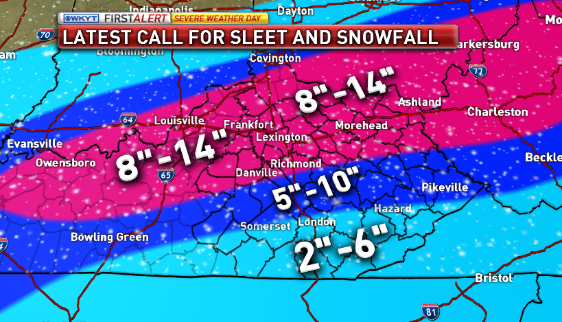
Here’s a look at my latest call for snow and sleet…
 The latest GFS looks very, very close to what I have…
 The European Model is similar, but shows even higher totals…
 The latest from a couple of the NWS offices…
119 out of 120 counties in Kentucky are under a Winter Storm Warning…

I really don’t have the time or the words to rip the NWS in Charleston like I want, but that map pretty much does the job for me. Just awful.
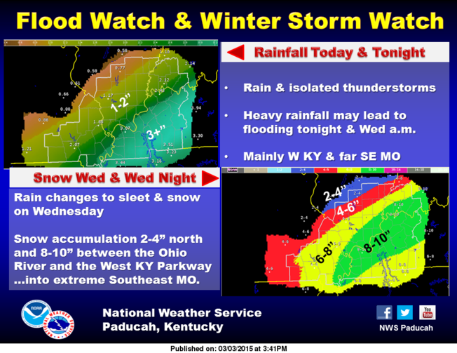
Don’t shortchange the high water potential tonight into early Wednesday. Heavy rain is a good bet and that could lead to some flooding issues along area creeks and streams and then some minor river flooding. A FLOOD WATCH continues for the entire area…


A brand new call for snowfall comes tonight at 11pm on WKYT-TV. Take care.

Thanks CB!
Thank you Chris
Whoever upset Elsa needs to apologize now.
Looks like Elsa made bail!
Folks need to take note of the NWS call for 10-13″ in Lex, it’s a VERY rare site for the usually conservative NWS.
As for that one county, you know to prepare, right???
Also, from this point forward, when we see a “winter weather pattern” forecast, February 2015 will be referenced for years to come.
As always, think spring
It’s March now.
Only because they short changed February in days. Otherwise it is February 31st.
lol
Oh yea, It is. Thanks!
This winter pattern has got me lost.
Think spring
Nothing from the Jackson office eh?
I keep telling everyone at work that we may get snow Wed night and they all said I was crazy that our local weather was saying it was going to be “Spring” this week, I said well they are wrong just wait n see! I had several people come up to me today and said ” you were right ” lol. Our local weather finally started talking abt it today! Lol
Wsaz is pitiful lol
Most Lex mets were saying the same thing and in the background ridiculing the non conformers.
Careful now Bubba. Your buddy’s watching. 😉
WSAZ still has my area in a 2 to 4 inch total. Their highest forecast amount for anybody is 4 to 6. I guess they are waiting on the Charleston NWS to tell them what to do. But actually the other local channels are just as bad. One doesn’t even mention accumulation amounts.
Last year we were in the middle of freezing rain and it was building up fast n wsaz said it was going to miss us, and I was looking out my window watching it build up as he was saying that! Lol. Have no faith in them! I only get my weather from Chris!
The frustrating thing is the governor has released a statement about preparing, so has Kanawha Co emergency management. The actual news had several stories about what cities are doing to prepare for the severe weather that’s coming, yet we have no warning and some aren’t even committing to, or suggesting, totals 24 hours in advance. Now if they drop a 10 inch snowstorm bomb in the morning, elderly people aren’t going to be prepared because it’s going to be raining cats and dogs tomorrow and they won’t want to drive I’ve that either.
That’s what I was saying earlier. It is a dis service to their viewers because the elderly don have FB or other social media to get updates and will have no idea this is coming until it is to late!
Yes they are! Lol
I’m in Boyd & I’m constantly telling everyone about the possibility days before & until it comes they call me crazy. Now they are asking me what Chris said. Lol
Funny, same thing happens to me. Same people that think I’m weather crazy start texting me as soon as they hear about snow. You actually learn quite a bit on this blog, too.
Yes they all say i am crazy buy they all come to me at work or on FB wanting to know what CHRIS Says! Lol. I am known as Snow queen And the FB weather lady! Lol
My parents ask what Chris says, and they live in east central Ohio.
is hart county ky in the 8-14 inches for snow any body
No disrespect intended,but all you have to do is look at the maps CB posted. Please don’t take that the wrong way. Looking like a good bet that Hart Co will be in that range.
ok thanks
Hart looks to be about 5-8″, enjoy
Hart is split down the middle on the map between 8-14 and 5-10
so which one is it please and thank you
Blake, if you live in North Hart County, you are in the 8-14 zone. If you live in South Hart County you are in the 5-10 zone.
Thank you Chris. Glad to be able to depend on you for the up to date forecast instead of my NWS.
Got me in the 2-6 range now. I will agree with that think 6 might be a stretch though
This morning when I left for work my yard was completely covered with snow. I still had at least 2-3 inches of snow. Now it’s gone. I wish I had time-lapse video. Bring on the snow!!!
My yard was completely covered with snow this morning. I had 2-3 inches on the ground. Now it’s completely gone. Wish I had time lapse video. Bring on the snow.
CB, I have no issues whatsoever ripping the sorry never get with the program if God himself told the NWS in Charleston WV that a foot of snow was coming turn a blind eye to any major event pathetic excuse for a government weather office.
Amen holy #### where’s the Tylenol!?!
It is so pathetic….I live in GREENUP and have had to deal with it for years
OMG!! Why does the NWS in Charleston do that to us? Like why? It is soooooooooooo annoying. It’s like a booger in a fruit punch bowl at a wedding, it ruins the whole thing! Or a BMW with a scratch on the front Hood. Or maybe This</a
Charleston will get on board once the snow starts then all the little mets that follow them will fall in line…. Yeah Right
In the spring/summer we’ll get a crazy storm here in Boyd Co then you’ll hear the warnings for WV. Every time. I always say they see what happens to us then go from there. Guinea Pigs we are. Guinea Pigs.
All I can say is… Let’s all go to Lawrence County!
Hey Chris, Will this be a wet snow? Or powdery like the last one?
Looks like heavy, wet snow this time.
is central KY getting the 8-14 inches?
Now Blake……
what don’t understand what you are saying please explain
What county are you in?
sorry hart county KY
5-10 inch zone for you
5-10 inch zone for you
Northern half of Hart is in 8-14, while the southern half is in 5-10.
Thanks for the update Chris! Looking forward to the new snow map! Hope that southeast Ky totals are more on SNOW!!!!! Just a little bit more south please!!!!!!
Look at that train forming. Good thing we got a ticket this time!
The WAA scares me as does the dreaded transition from rain to snow but I will say, it was 63 at my house here in The Ville around 640pm. Down to 58 now. Long ways to go. Bring on the snow! GO CATS!
Just for being a cats fan living in the Ville (which is blasphemy I might add) may all the WAA circulate over your house you only get a cold rain. lol
Hahaha. Grew up in London, Ky. So I was raised loving the Cats. Moved to the Ville about 8 years ago.
March Madness already and the conference playoffs haven’t started yet.
I agree. Go Bulldogs!
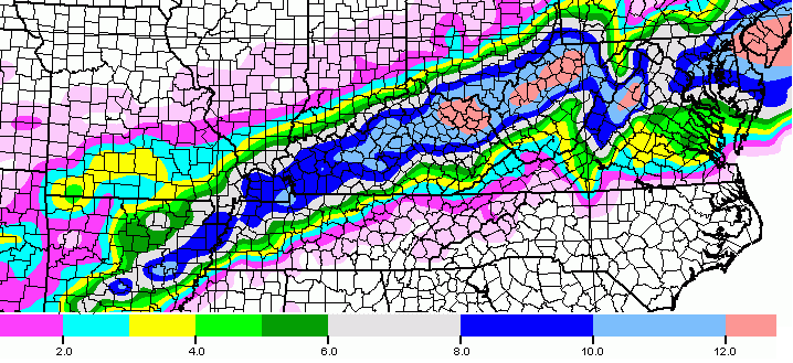
Here is the NCEP NDFD Snowfall accumulation forecast. (AKA, the NWS forecast.)
http://pbs.twimg.com/media/B_NXrl4WsAAxOf1.png
That looks like a huge amount of snow for KY.Louisville even gets a big hit. I still want to see what later model runs show. Still a ways to go.
I can remember how people were discussing a semi-drought in KY… It’s amazing what a few weeks will do… Hope everyone stays safe. And CB, thanks for all you do..
The NWS in Charleston has now upped the snow totals for Huntington, WV to 6-8. THEY
STILL DONT HAVE A WARNING FOR THE AREA!! Lol
Of course not there probably going to issue a Severe Thunderstorm Watch them clowns.
Lol
Thank you Chris! We love you! Looks like you better get a huge pot of coffee on!
Why is Logan County West Virginia not undera winter weather advisory?
I have a hard time believing this will be a wet snow if the temps plummet from the 30s to the high teens during the storm. I guess we will see.
Anything is possible! It is in the upper 50’s here in Spencer County right now, and we are talking about 10 inches plus of snow starting in the next 18 hours. Yep … only in Kentucky!
5pm-Should be snow by then, maybe sleet mixed in and heavy wet snow.
12am-All snow, heavy, temps in mid 20s
7am-Heavy snow- temps in mid teens
So, it will start off heavy and wet and gradually get drier as time pa-sses. Don’t be fooled, As the heavy snow starts, even if it gets colder the snow will soak up the water underneath (A lot of rain before) and will freeze creating a sheet of ice under all that light fluffy snow you will see on the top by Thursday morning. So windshield wipers should definitely stay up during the day tomorrow as rain turns to snow and the water freezes.
This storm better call Saul.
This storm is deciding to Break Bad instead. 🙂
Anyone else concerned that the short-range models are moving the vast majority of the snow north, out of Kentucky? SREF has also dropped totals down an inch or two from the 15z run to the 21z run. Fingers crossed!
I hope not. I’m all excited now, and I finally found a snow shovel. Lexington better get a good wallop, since I had to drive all over the city looking for a shovel! LOL
Your dog will be happy.
The short range models you speak of are only seeing the very initial changeover to snow, which was always beginning in Indiana. As a matter of fact, I believe they are showing the colder air taking over quicker than previously modeled.
If that’s the case, If anything we have to worry about the second plume of moisture being pushed too far south (For Louisville).
Yep I was thinking the same thing
I thought I heard that the name of this storm is “Thor.” Did anyone else hear this??
You are correct!
Yep, that’s correct.
Yes it’s a naughty storm with a male stripper name, Thor.
Only The Weather Channel names storms. Usually meteorologists at other stations refuse to use the names because they think it’s stupid to name winter storms and TWC only does it for dramatic effect
The weather channel is a reality show. They throw in these names thinking they gain prestige, but they only look foolish.
^^^nope dont care. Let it go north. I dont want to be stuck in my neighborhood for two days because they wont plow and look and manowar and tates creek cleared off
Sorry meant look AT manowar and tates creek
My roads are the same way. I live at Ogden and Star Shoot Parkway. I see Sir Barton clear, but those roads aren’t touched for a while.
For die-hard snow lovers, which does include me, we want snow anytime. (Though not exaggerated, like anyone else) I mean I also got stuck in my house and nobody could leave the street in my neighborhood that went uphill for a couple of day, unless you had the good trucks. Yes, it is bad, but I see it as a challenge of life, courtesy of mother nature. I see the positive side of things and like to go through new experiences. I accept whatever mother nature throws at us and make the good out of it, doing fun activities with family and hanging out together when we know we’ll be stuck for a while. It was a thrill for me to experience the biggest snowstorm I have ever seen a few weeks ago, and I embraced the memories I made and the new experiences I went though, even not being able to drive out of my neighborhood for several days. And no, I do not want tornadoes or ice BUT, if any tornadoes, I would like to see them in an open field where no damage is done and no lives are lost. So with this storm, Bring it on!
How are the predicted accumulations so drastically different. Chris has me in 8 to 14 and WSAZ has me in 2 to 4. Wonder what one is seeing that other isn’t?
New NAM is coming warmer and also less moisture. Changeover in Lville won’t be till late afternoon. This will lesser snow totals.
It doesn’t run til 1030?
It’s running right now lol
Yeah I just saw, oh thing really diff is that it shifted south lol
It hasn’t changed just corrected to what the Euro and GFS is stating, Mr. Bailey just tweeted.
More realistic with totals now. I’ll take another 8” of snow. 16-18” wasn’t happening.
Actually the Louisville Mets have said the change over to snow wouldn`t occur until around mid afternoon and the heavy snow would , I think, be from 8:00 to around 4:00AM Thursday.
4am on Thursday??? Yout way way way off on that if that’s the case Louisville gets a dusting. Storm is pretty much done by 4am
Nvm Tim my bad read your post all wrong
False…maybe slower but deff not less moisture
http://www.instantweathermaps.com/NAM-php/showmap-conussfc.php?run=2015030400&time=PER&var=ASNOWI&hour=042
Oh yeah bro in Lville it had 2.2 earlier and now down to 1.5 lol
Has less moisture on the front side, but not when it counts.
Yeah it dropped .4 precip
I’m in scioto Co. I see our projected snow amount(including sleet), but how much of it is actually going to be snow?
What time can we expect the changeover to snow around ashland ky?
NAM looks super for ne ky now compared to its previous runs. So we now have the gfs, euro, nam in agreement on ne ky. Is this a slam dunk at this stage?
No such thing until it happens, but much less doubt than normal so far. Seems NE KY is positioned well for the main stuff.
CB and others speaking of a southern shift on NAM. Can someone please post it?
sorry…I just saw it
Still showing around 2 inches for seky so dunno how far south it went
Southern Indiana and Louisville still positioned to get 10″. Not sure about a shift. CB said NAM lines up with his predictions.
Does anyone know when the change over is expected in Lex. ?
mid to late afternoon
Snowmagedden II is on the way! Batten down the hatches and keep your powder dry!!
So, basically a bust north of 64 like last time? Less moisture, quicker change over, higher temps?
Where are you getting that?
The latest NAM run? NAM is spitting out 0.82″ liquid equivalent as snow versus 1.37″ in the last run.
So you wouldn’t be happy with 8-10″ of snow?
Ky we,what are you considering a bust?
No words, just….. No words smh
A bust meaning it will probably be the lower end of the projections. Still a nice snow.
Obviously, you don’t understnad the meaning of the word “bust”
If it’s within the projections, how is that a bust?
You should probably step away from the computer for a while.
Hitting the imaginary LIKE button
lol, how many times has your wife said that to you Chris Bailey?
00z NAM has shifted further south. Though is is weaker with less moisture, but more widespread across Kentucky. No solid band of 14-18 inch on this run, more like a widespread 8-12″.
24hr waffle, same old NAM
Which is more realistic
Still shows 10″ for Louisville and central ky. Looks good for a good part of southern, IN and kentucky.
Gfs runs soon right?
http://twitter.com/kentuckyweather/status/572950292649525249
The nam
I guess the only thing I’m concerned with is weren’t we (Central Kentucky) supposed to be getting all of the rain that currently is going completely north of us? As of yesterday they were saying we were going to be getting severe weather and several inches of rain today into tonight and it hasn’t rained but some sprinkles. Not that I’m complaining because I certainly don’t want several inches of rain, but I’m a snow lover and I’d be sad if the snow did the same thing!
I never said that and only had a few showers for today with the heavy rain arriving tonight and Wednesday morning. 😉
Cool 🙂 That’s why I said “they” because it’s all so confusing with so many forecasts! lol. I should just listen to you like I always do!
“I should just listen to you like I always do!”
Oxymoron?
Always end up doing 😉 I do look at other forecasts. 😛
I was just getting ready to say. Look at the radar. Lots of rain about to move over the state.
It was moving pretty straight north of us here in Lexington earlier. Still haven’t had more than a few minutes of rain at this point. But yes, seems to finally be filling in now 😉
Chris,I thought you said the Cats would be winning by 50 points by halftime over Georgia?
Just kidding CB. Thanks for all you do for us
Another 50 miles to the South would be great. KTHX, storm.
Around what time will the rain change to snow in ashland?
If I’m looking at it right, looks like sometime during the evening – late evening time period
What a mess – rings a similar bell to the March 1993 blockbuster that hit KY.
Down to 51 here in Louisville. Across the river it’s 44 in Paoli and 35 in Indy. Cold air is getting closer.
Yep, it has dropped 6 degrees here at my house in Lexington in the past hour. Was 60 at 9:00…not sitting at 54.
55 at tates creek/manowar…just finished grillin out and a fine mist starting to fall
We just had big raindrops falling here in the Hamburg area. Seems to have let up a bit for now.
How busy was Meijer Ashley? Walmart and Kroger were both packed tonight
I was at Meijer earlier today, but it wasn’t terribly busy then. I’m sure it got busy as more people got off work. Luckily, I was off today and could get my stuff done early!
It is now 48 here in Edwardsville, Indiana area. (Floyd County, IN)
I’m in Covington and just watched the local news. Met said that she doesn’t anticipate us (as in counties around Cincinnati, ie Boone, Kenton, Campbell) getting a while lot of snow. Showed a nice little graphic that kept all forms of winter precipitation to our south. It made me quite sad.
What station?
nothing to see here folks….move along
You’re so funny Mike
Scroll on down. Keep the line moving.
I’ve been to Pulaski, and you’re right
Its down to 41 degrees at my house in Burlington / Florence area of Northern Kentuckinnati. 😉 1.11″ of rain so far at the Boone County Mesonet, plenty of local flooding issues tonight in the extreme northern areas of the state, 71/75 has been shut down at times in the Ft. Mitchell area, and some of the onramps in downtown Cinci.
When does gfs run?
should be in the next 20-30 minutes
Finally got the storm warning in Kanawha.
If you don’t like a whole lot of snow, just join us down here in SEKY where the dome is still intact. Doesn’t really matter to me this time of year if we miss out or not. Would of like to have seen more than 5 inches with the dry snow a couple of weeks ago. want no part of wet heavy snow. Bring Spring.
On a side note…being a UNC fan i dont normally pull for Kentucky but they are in danger of an upset tonight… Come on Cats!!! I wanna see a perfect season!
Oh my word! I’m a UNC fan as well. Born and raised in NC. However, I’m for the Bulldogs.
Rematch against Duke this weekend!!!! #heelsforever
I’m ready!! #goheels
^^^like!!
People after my own heart! Ready for that rematch! GO HEELS!!
UK brings it and wins #30! Go CATS! 🙂 I hope UNC clobbers Duke!
Yay for Ky..72-64 win.Intense game for sure.
GFS also lowered the precip
GFS continues to look faster, somewhat farther south. Still a very healthy snowstorm for KY but will anyone top a foot? NAM says maybe. GFS says most likely no. I wonder if the Euro will still have it’s extreme totals? Widespread 5-8 inches looks like a good bet regardless. Being March, I will take it!
Got a link?
Hoping whatever falls tomorrow/night melts fast unlike the last storm. Im ready to get the new bike out and put some miles on her…
I see high snow totals an no mention sofleet in this update. Are you anticipating a quick changeover?
http://twitter.com/kentuckyweather/status/572979989823418368
Gfs
Yeah, 00z GFS confirms what the latest NAM is showing. A much weaker system and more south. Don’t get me wrong, this is still a high impact, significant winter storm. It’s just that we’re not getting the “Drop the mic” model runs or scenarios that looked like a possibility before. But remember, things can always change. Still, this looks to be more in Kentucky than anything. So basically from tonight’s runs, we have got less snow for North-Central KY and into Indiana, and more snow for SKY. And in general, a more slow, weaker, more south system. Curious if tomorrow’s last minute 12z run will ramp up snow totals again or if it’s already set in stone since tonight.
Oh, and the bulls-eye looks to be setting up over Lexington, but not looking like we will get significantly higher amounts due to the absence of banding that the models were showing earlier.
But is any of this flat? THAT is the question. 😉
I think you are talking about a bigger snow. I agree there, but never thought a drop the mic was going to happen due to the cold air timing and sleet factor.
I am not seeing a much weaker if any system and CB posted a model run supporting his maps. Things can change and we could get a lot less snow than expected (ok by me), but that is not how it seems for now.
If you are referring to higher totals than CBs maps, then that seems to make sense. The timing of the cold air and altitude temps are something models miss, so rain and sleet can cut totals big time for areas especially on the southern side of the path.
I know folks want big snow, but double digits of heavy wet snow can be ice storm level issue bad. Worse in regards to mobility with vehicles. No offense to snow lovers 🙂
A lot weaker system though would be sugar bear sweet.
You ruined my funny flat comment with technical stuff Bubba G.
Oh my, lol!
Says the guy crying for a snow in Richmond a month ago 😉
GFS puts much of EKY in 10-12″ range.
NE KY, sorry.
Was wondering about that.
Let the water watching begin for us creek dwellers.
I noticed weather channel has dropped Lex. to the 5-8 inch range from 8-12.
I just looked at their snowfall map and it still shows 8-12?
With the dynamics of cold air timing and sleet, barring a path change of the system, any numbers at this point easily can be off 50%.
Kind of a nowcaster for totals. Again presuming the system path does not pull a honey badger overnight.
Interesting. They switched it back. I swear for a short while it had been decreased.
Oddly enough I noticed it do the exact same thing on the last storm because it’s the first thing I thought when I saw that tonight. Had 8-12 inches up until about Sunday afternoon and then switched to 5-8. We ended up with 10. So who knows… lol.
Euro should tell the tale 😉
http://www.tropicaltidbits.com/analysis/models/nam4km/2015030400/nam4km_asnow_seus_19.png
Hi-res nam seems to be pushing the precep a little more south and east..Hopefully a trend for southern ky..
ECMWF usually unreliable-ish this close in. But it has the highest totals of any model and is showing 1ft+ for all of central KY, 10″+ for SKY and NKY. So asically has the whole state slammed except for SE KY, unfortunately. ALL of the 00z models indicate the heaviest snow in West-Central KY thhrough Central and NE. Don’t really buy into it at all, mainly because it isn’t a higher resolution model like the NAM, but we’ll see.
Have a map Israel?
Euro a touch south from earlier but still a big hit for a bunch of us.
Liking the SE trend..This time tomorrow the whole state will be covered..Models underestimating the cold air push..Maybe?
More south = less snow in general but more snow in places to the south.
You folks are nuts, just trust Chris and and quit the arm. Chair forecasting !