Good Wednesday, everyone. Our major winter storm gets cranking today and this will throw significant amounts of snow and sleet our way. Before then, we have a lot of rain to go through early today and this will likely lead to some flooding problems.
I don’t want to overlook the high water potential, so please keep a close eye on water levels if you live in a low-lying or flood prone area.
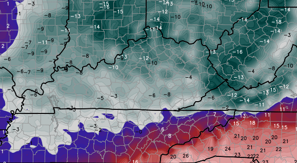
The winter part of the forecast remains largely unchanged from my point of view. The latest models are settling in and are very close to the snow map I put out Tuesday afternoon. Here’s the NAM…
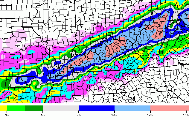
As expected, the NAM has been slowly correcting itself from the far northern solutions it had been showing of late.
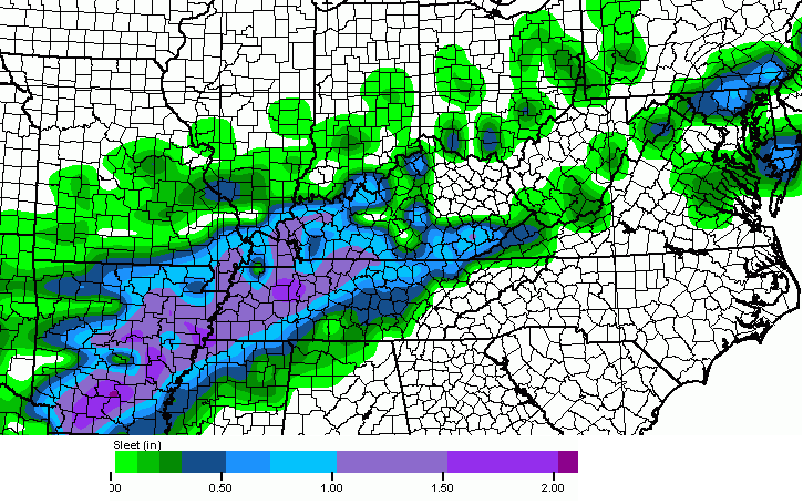
The model continues to show a lot of sleet…
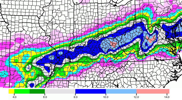
The GFS is just a touch farther south of the NAM with the axis of heaviest snow…
Here’s the sleet forecast from that same model run…

That’s a ton of sleet across the south and southeast!
The European Model is rolling in as I type and it basically stays the course with what it has been showing of late.
Moral of the story… I have no real reason to make changes to my snow map as of now. Of course, I will freshen it up some with the final call for snowfall later today.
I want to stress… most of the accumulating stuff does not begin until very late today into tonight!
Bitterly cold air comes in behind this system and the models are showing the coldest March temps ever recorded around here by Friday morning…
GFS
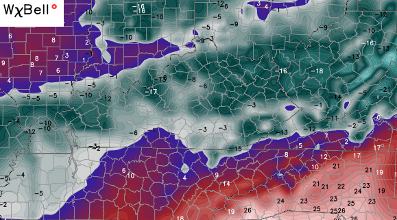
EURO
 I have two words for those temps… Un Real .
Updates will come your way later today. Until then, track away…


Take care.

Thanks, Chris! Guess all we can do now is sit back and watch it roll in. No doubt, my husband will have to roll out to work on power outages.
Very appreciative to your husband, and others, who go to work in bad conditions to keep us safe and warm.
This is going to be a long day ahead of us as we watch how this unfolds. Crossing my fingers we get big snow like last time, while the others of you hope for a bust.
The rain is really pounding down. Good luck to all of us. No power outages, please.
Thank you, Chris. Isn’t this your third anniversary for returning to WKYT? We are so lucky to have you.
Yes it is! 🙂 Thank you very much!
Happy Anniversary. Best thing that. Lyle have happened to WKYT and our community.
Best thing that could have happened
Chris I work with Stacy H Floden, (DJJ) she says Hi!! She says you guys spent allot of hours working in the studio’s prior to your first departure. I turned her on to your Blog, she loves it and so do I, Thanks for your dedication to this Blog>
Not discounting the flooding threat here in Carter County. Up watching the creek. Once you have been awakened by two feet of water surrounding your house,and having to flee your home with everything you can carry in your arms, you tend to not forget the feeling of terror.
Think the bust card is gonna drop along the 64 corridor…..:(
Here we go again! Just hope later that there isn’t any power issues. Hope you are doing good Chris, just wanted to say Hello also 🙂
Not really seen a whole lot in the way of rainfall here in Harlan County, yet the river is very swollen. The snow melt from yesterday as well as night is creating A LOT of water.
Lightning strikes now popping up within the heavy rain in far western parts of both Kentucky and Tennessee. More importantly, Flood Warnings continue along several rivers and stream across our region. As the saying goes, Turn Around, Don’t Drown!.
At least there is relatively good news about the freezing rain threat; the WPC now feels that freezing rain may not be too big of an issue, although far western Tennessee may still have to endure a bit of a more elevated risk of ice before there is the transition over to sleet and snow. NWS Nashville is also not expecting a big ice issue as stated in their most recent Forecast Discussion. Still, it of course only takes a millimeter of ice to cause big problems on the roads and sidewalks, so please use caution.
Thanks CB for all your tireless work 🙂 .
Along with the various Flood Warnings, now a Flash Flood Warning for several counties along and near where the Wabash River flows into the Ohio River; Henderson KY and Evansville IN are two of the larger cities involved.
Already dropped to 39 here. Change over isn’t predicted until 7 pm. Could we see that happen sooner??
http://wxcaster4.com/nam/CONUS1_MESO-NAM212_SFC_ACCUM-SNOWFALL-KUCHERA_72HR.gif
This is the latest nam run
Looks bout right. You can look at the radar at tell who’s gonna get thumped and who ain’t already
Already called public schools off in Jefferson County in anticipation of the stormy weather ahead. Thought we might have an early dismissal, but no. Stay safe everyone! Thanks Chris for keeping us well informed!
Thankfully, my son goes to a private school. So, they tend to lean towards whatever the JCCS does. 1pm early dismissal, which alllows them to get an official day in without make-up.
Pouring rain steady in Lex. The heavy rain part has definitely materialized…..just as scheduled.
This got me thinking, with heavy rain to big snow, I guess they can’t salt the roads, can they? How would they? Would it be pointless in a situation like this? Not that salt would help with intense snowfall rates.
I’m still in shock that we have the potential to have, not one, but TWO blockbuster snowfalls after our over a decade of big snow storm drought. I was more than happy with what we already got!
Saw WKTT news yesterday and they were saying they haven’t pretreat the roads because the rain will just wash it away, they will start treating once the snow starts they said. So you’re right.
*WKYT
The waters are breaking there banks in Blackburn Bottom in Pike co how much more rain do you think we have coming towards us ?
What time is the changeover supposed to happen?
Afternoon north, early-mid evening central, and mid-late evening south. May take longer to the south where all snow won’t be expected until past midnight if towards state border.
Rolo,
Not too late to ride the Rolocoater on the up part of the tack now 😉
CB rocks, but I would not mind at all a snow map miss that results in no power issues 🙂
Rolocoaster. Get on ride!
Well its hard as a snow lover to watch a huge snowstorm as this miss me to the northwest..but on the flip side of this is its supposed to be 70 here in east tn. Today.. With very little snow and ice forecasted for tonight and tomorrow.. With sunshine and 60 forecasted for the weekend…so I think its full steam ahead for spring!!!..lol..
Good thing is that if you lived in Knox Co. you would be missing them to the north too. You’ve had about as much snow south of us in TN as we’ve had up here.
he probably has had more in 1 event than we had all season.
We had 8″ in last storm and 3″ two days before that.
Then I guessed right
Flood Warning issued for Boyd and Carter.
a couple big rumbles of thunder went through NE Louisville around 6:30-6:45 this morning.
Current temp is 39.5
Song of the day…Carly Simon ANTICIPATION.
of not losing power 🙂
Greetings from central Florida this morning. Upper 80’s for today and tomorrow. Been cruising in the Bahamas last weekend.
Don’t think that it has been all great all of the time. The travel through Chattanooga last Wednesday was rough, over 6″ snow with blinding visibility at times. Nice to get away from this stuff though. The snow forecast sounds unreal. However, do not underestimate the accuracy of the NAM within 24 hours of the event. I still like 5-9″ for Louisville. Look forward to seeing how this all plays out.
5″ for your house, and 9″ for mine is all you have to say Mike! haha
enjoy your time in Florida.
Micha Harris just said the system is showing signs of slowing down, and this could cut down on totals, interesting
Sometimes Micha plays things down . Trying to say that in a nice way. Chris and Jim Caldwell are different on a good way.
Michael just said the more he looks at the trends it could be 8 pm before the snow arrives, and parts of eastern ky it could be Thursday morning
Micha not Michael thanks auto correct
Never underestimate the power of warm air. Hard to budge
Seems like that is what Marc Weinberg said out of the Louisville broadcast last night. However, he wasn’t lowering totals and said there would be plenty of moisture for the cold air. If it’s going to come, it needs to go all out. I don’t want another stupid rainfest.
Micha did not say he was lowering totals, just that a slower system has the potential to lower totals, basically something to watch.
Well, the system better pick it up. One more big blast and I’m done for the winter. Bring it on! 🙂
Begin to sleet here far western , ky. The weatherman has hit the nail as far when rain will translate to sleet. I don’t think this system is slowing down
That would of course cut into totals with a slower start. Will be interesting during the day if the changeover slips out. Warm air don’t care about no models 😉
Stop in for mandatory weathercenter update…..✔️…..now lets get it done today before the storm hits….LOTS of pooling water on manowar so be cautious even this morning
Louisville still looks to get hit hard. Certainly hope all of the anticipation does not turn out to be a let-down. Seems when temps go from warm to cold quickly or v.v., the predicted snow totals are too high. It’s wait and see now. First we were told 8-12″. I expect at least 8″ then.
BUST!!! I just got the feeling going bust on snow, think main precip be gone by time it get cold nuff.
Well you go right ahead and think but in reality that’s not going to happen you got two storms in the process of phasing look to the west and south. Plenty and I do mean plenty of moisture feed. As far as the cold getting here its pretty much here temps are starting to fall a degree or two in hour over north central kentucky and that’s all moving south.
Its 50 here atm but I agree it is very slowly dropping
39 degrees in Louisville, 20 miles north of Louisville in Henryville Indiana temp is 35. Upper 20’s in St.Louis cold air its coming
I wonder if CB thinks it is slowing down?
I’m with ya Rolo. Ain’t now way we get snow after 60 big uns yesterday and all this rain today. This has bust written all over it and that would make this old guy so happy I could slap my pappy. I’m done over this winter bring on them warmer tempratures. Y’all go clear out the walmarts shelfs but I’m with Rolo on this bust.
So people are already calling bust and its 830
In the morning lol ok then
Some people expect it to be 32 with snow falling the minute they look out there window and if that’s not the case its a bust? That was never forecast, everything is still on track. You’ll get some people saying I only got 6 inches but down the road 20 miles they got 10! What a bust. I just shake my head and chuckle to myself.
Rolo has decided to not ride the Rolocoaster and sticking with the down track of bust. Part of me hopes he is correct, but most of me thinks he will not be.
A bust BTW means the average of the area snow totals is under the minimum map range. Not seeing that, but a combo of warm air hanging on and sleet could mean an interesting challenge to get a lot of accumulation.
Like the last big event that did not pan out for most, warm air should not be underestimated.
Chris also said the storm was a complicated one and he also didn’t have 8-12 inch totals forecasted for that mess. Use your common sense. Don’t think Chris would throw out high numbers unless he was pretty darn confident. This is not the last storm, or even the storm before that, although there are some similarities to the big one.
Nws in Louisville also said the system seems to have slowed and the transition will occur later than expected, also this could lower totals based on the 06 runs. but they are not making any changes to the totals as of yet
A slower system would be more snow cause it take longer for the moisture to move out. Whoever said slower system = less snow isn’t doing their job very good
Amen.
on the contrary …. a slower system could mean warmer temps stick around longer than expected, thus slowing the changeover to snow, hence lower accumulations.
Flooding has been reported in the Rush area of Carter County.
Already 0.6 of rain and the heavy stuff hasn’t even gotten here yet
Rodger sees this as very interesting. Slower changeover to frozen likely but perhaps more moisture than previously thought after the changeover. This winter has brought some extremely difficult to forecast systems. Rodger will be happy with 4 inches. Anything 8″ and more is obviously very rare in our part of the country. Still possible but likely??? Rodger in Dodger!
The snow totals have always been tied to the changeover, the faster the changeover the higher the totals, nws in Louisville stated that they believe the totals should roughly fit the current forecast
8 ft is a lot Rodger in Dodger 😀
NWS increased totals for London. Now up to 10 inches. (Up to 7 tonight and 3 more in the morning.) Is this due to a “slower” system arriving after the cold takes over???
Apparently yes. CB tweets could be telling.
http://forecast.weather.gov/MapClick.php?map.x=126&map.y=206&site=jkl&zmx=1&zmy=1#.VPcMrYE8KK0
4-8 inches for London according to the nws
Remember that’s snow and sleet. Barbourville seems to be unchanged 2-6 of snow/sleet
Chris Bailey how many inches for hart county KY
Schools are still in session in many areas of our state. Let’s pray that all get home safely. We do have flooding here in eastern Carter Co. Nancy in Olive Hill please stay safe.
You too MT. Prayers! Thanks.
Sigh
Maybe this is why there upping totals..Surprised no one has mentioned the overnight run of the Euro..
http://i.imgur.com/drCAyAR.png
Just sold some more bread and milk..Pet and kroger send money..
Seems the models went from all agreeing to some deviation now. You would at least think they would figure out if a fast or slow mover by now.
I am less confident in the higher totals actually happening now, but that is more due to my respect for warm air. It sure punked last weeks system to mainly rain for most.
Watch for the map totals shifting more east NE. That could suggest a fast mover.
One more thing before I head out into the Florida sun is our (kentucky) temperatures may stay above normal for a stretch by mid March. I’ll be through with winter by the time I get back.
It has been absolutely pouring the rain here in GREENUP…everyone stay safe
The Louisville met on WDRB just said we need to back off the totals for the Louisville area. Last night they were calling for 8 to 12 inches. Now he is saying we may get 5 or 6 inches at most.
Why am I not surprised?
Funny! Some models suggest slower moving and some fast. A fast mover would cut big time into totals. The models have shown the big totals more NE as far as the path and that would support a trend of a faster moving system.
CB maps should still be good, since the system would have to deviate a lot to not get the minimums on the map. Will be interesting to see once CB gets a nap in how he thinks the new runs might change totals. Seems the totals are less likely to go up and more likely to go down some.
Less snow, less shoveling and less chance for power to go out. That would be a win IMO 🙂
Amen!!
I watched him at 7 this morning he said 5 to 10 inches. I guess he must of lower his snowfall totals in the last hour or two
not that I don’t respect and appreciate their opinion on the evolution of this storm, just because they are scaling back, does not mean this will happen.
I have yet to see any of the other 3 stations pull back, nor has NWS (yet). When I start seeing the most conservative ones pull back aka: WHAS11 and NWS, along with WLKY32 to some degree, then I will believe we are only getting a few inches.
If this is the case, then once again JCPS made the wrong decision in cancelling school today. They seem to cancel when not needed and not cancel when needed. Sometimes they get it right, though. 😉
it is currently 37.1 in NE Louisville
Lewis Co. is the only school system closed for today. Wish all others here in NEKY had at least called for a one or two hour delay for this morning. Good call Lewis Co.
I don’t know how much a delay would have helped with this rain. The water is just going to continue to rise all day. They should send them home soon.
Mason, Fleming and Rowan are all calling off by 1:30
In SDF, watching the temps closely. It’s dropping (at my house) by a degree every 1/2 hour or so, 37.9 right now at 9:26 a.m. At that rate, shouldn’t it change over by early/mid afternoon? Just looking at the radar, I see solid moisture back to OK…I think the CB totals above will be spot on. (Or more possibly)
Wow, woke up this morning to no snow cover for the first time in over 2 weeks, but the holler is quickly becoming a pond! It was 60 degrees in the Millville area after the UK game last night and it’s now down to 40 degrees with steady rain. I’m not looking forward to the ride home from work. Stay safe, everyone, and thanks for all your hard work, Chris!
Nam looks to have shifted the heavier bands a little more east..Anyone else see this?
Got a link?
That started some last night. I was expecting CBs map update to reflect this but he might have wanted to see if showing same now.
12z NAM continues to lose the extreme snow amounts. I think this is a solid 6 inch storm for most of KY but anything higher then that might be wishful thinking.
On another note, completely shameful that JCPS closed schools in Louisville today. Snow is not even going to start until late afternoon (at the earliest). Get a grip!
CB might have some map downgrades. The minimums could end up being the maximums. Interesting how this close and still doubt.
Agreed on the school closings.
Key word is might. He could leave it as is and call it model noise.
just a side note…any 12z run is now not reliable, as this is now a nowcasting storm. Only the short range 3hr models tend to be useful at this point. Now is the time to watch the radar trends to our south and west, and really just looking outside to see when the transition occurs where you are.
I also seen where the NWS scaled back some, but not much. They are now going with 8-10″ instead of 8-12″. They are going with up to an inch of sleet before the snow takes over, which is where the 2″ come off the top end of the snowfall totals.
I do agree with the JCPS comment.
I don’t know what you are looking at 12z still shows a broad band of 8 to 14 inches. http://wxcaster4.com/nam/CONUS1_NAM212_SFC_ACCUM-SNOWFALL-KUCHERA_42HR.gif
You are really making it hard for me to will this to less snow 🙁 😉 …….. 🙁
Don’t take those maps to literally. Sleet will cut into snow totals across central KY. A changeover to all snow won’t happen until this evening in central KY. Snow ends by sunrise tomorrow. Could 12 inches still fall? Sure, but a smart man wouldn’t bet on it in March in the lower OV. 6 inches is a great storm. Anything over will be bonus.
Many school systems closed for flooding and understandably so. Lexington roads are quickly flooding and becoming quite dangerous. I don’t know about Louisville, but it’s not worth the risk sometimes.
Louisville had nothing to do with flooding.
It was a snow call, which won’t even start until mid-afternoon.
There is some serious flooding on roads at UK. Be careful out there!
Uh oh bubba, the nam puts Richmond in the bullseye for the heaviest snow
Got a map?
Not yet but to the naked eye you can see the heavy amounts have shifted south
Fayette County south looks to be the bullseye as of right now. I’m prepared in the Hamburg part of Lexington! 🙂
My efforts to “will” less snow seems in doubt 😉 🙁
4-k nam still has Louisville in the hot zone..lol
http://www.tropicaltidbits.com/analysis/models/nam4km/2015030412/nam4km_asnow_us_13.png
This is hi-red correct? More reliable closer to storm?
To be honest this system is in nowcast mode, meaning radar returns are far more important than models
That def is a long plume of moisture on radar
The link isnt working 🙁
worked fine for me
Interestingly enough SW Jefferson County in Louisville looks to be the spot for higher snows possibly. You know that would be the case with Mike S being in sunny warm Florida. lol
9″ for Valley Station, 6″ for the Airport (official, rolls eyes), 5″ for MikeS, and 10″ for ME! lol
Update sent to Public Protection Cabinet employees a few minutes ago:
Just finishing up conference call with the National Weather Service regarding the upcoming weather event for Kentucky.
Essentially – the timing of the temperature change which will lead to sleet and then all snow is being pushed back 2-3 hours; temperatures will drop quickly this afternoon.
Heaviest snow this evening from 6 p.m. to 2 a.m. with snowfall up to 2 inches per hour at times; winds gusting to 20 mph.
Snow amounts: central KY 8-10+ North of the Ohio River and in areas in southern Kentucky 5-8 inches predicted.
This is going to be a heavy snow so scattered power outages are possible. Event should wind down around late morning Thursday.
Friday morning, expect record cold temperatures likely below zero.
Chris just had a tweet where he said the cold isn’t slowing down and his totals are right on line…we shall see
http://wxcaster4.com/nam/CONUS1_NAM212_SFC_ACCUM-SNOWFALL-KUCHERA_48HR.gif
The 12z of the nam
Is this the run that can’t be trusted or whatever? I saw someone say that certain runs of the NAM are less reliable than others?
Thanks always for the tweeted updates Chris.
I’d like another biggun’ , but we’ll see.
Really enjoyed tuning in the Reds on radio yesterday.
Solid run of the NAM. Latest rap is looking good for ohio river counties. Already 6-8 inches by 3 AM
You have a link to the rap?
http://www.youtube.com/watch?v=LyN2RtR1P-A
I could only get through about a minute of that…..
Wow…
That young man LOVES weather and he has a back story of the type where I do not want to see anyone here ignorantly making fun of him.
No one is making fun. We need webcams sometimes so people will see our faces as we type. Good grief.
I love that he is enthusiastic about the weather! However, I only listened for a minute and got the gist of what he was saying.
I completely agree with you, LD. I noticed this online and appreciated his enthusiasm.
That was awesome!
I see he has made many videos like this for other areas of the country, as well.
Frankie is THE MAN!!!!! Huge online following. Lots of support for this guy.
Seky usually does not get much out of a setup like this.
Not liking the setup with a later turnover. Louisville won’t see snow i until after 6 and on the northern fringe of the heavy stuff. I see a 2-4 for most with higher totals south east of both Jefferson county and the state.
CB just posted on Twitter he expected change over in Frankfort around 3 PM and Lexington during the evening commute. I guess we’ll see who is correct on this one!
Yes, it might say 39 at the heat island (airport) in Louisville, but, it is already down to 36 here in NE Louisville and down to 34 in LaGrange.
So, the changeover will happen well before 6pm in Louisville.
It is 35 in New Albany already.
Agree. I am two miles from airport and four from downtown. Trends are trends IMO. Hope you get 10 and we get 4 easier to move
I don’t disagree with you very often….I think this will be only the second time now. But, I can’t see Louisville not getting at least 6″.
2-4″ seems very low. If you are right, you will look like a genius, though.
Here is the latest Wave3 snowfall map. I like where the placement is, for the most part.
http://twitter.com/RyanHokeWAVE3
You never know. I just read that it was already mixing in southern Indiana. Maybe it will transition faster than everyone thinks? I just hope that the freezing line doesn’t hover over the river all day like it usually does.
It won’t hover…I’ve noticed a 3 degree drop in the past 3 hours. So, at that rate, the sleet and snow should kick in by 2 pm in Louisville metro.
Its a changed over to sleet in French Lick that’s not to far away from Louisville
Yes, lowering the snowfall totals is not what I would have done.
At this point, you just have to not give in to a knee jerk reaction, and pay attention to the radar trends and reports from everyone on what they are seeing.
I still think 6-10″ for Louisville is a good bet, maybe 8-12″ for Lexington.
This could surprise and switch over in the next couple hours, instead of late afternoon early evening.
If it does, the higher totals will be most likely and possibly pushed even higher. If not, then we will see more 6-8″ snows reported in most areas.
It is mixing in southern IN. Friend of mine says it is more than just rain and getting colder.
Yep. Going to be some disappointed people who are thinking 12 inches will fall in their backyard. Although I still think most of metro Louisville sees a solid 6 inches. The later changeover downstate will eat into their snow totals as well.
I think we are in nowcast zone. Some models flake out now and some hold on.
http://twitter.com/Kentuckyweather/status/573139756005101568
They should put a “#notafloodevent” hashtag (from Tuesday’s post) on the pictures when they send them on Twitter.
my wife is in Pigeon Forge till Saturday … said the sun is peaking thru and the temp is 70 right now; also said local met in Knoxville lowered their snow totals from 3-5″ down to 1-3″
Looks like the focus of the system is Kentucky. Might not be a focus we want though. I prefer the powder snow from two weeks ago. Dealing with heavy snow is a much harder thing in almost all regards.
I hope this is over soon looking bad behind my house.
Prayers
Has meteorology always been this competitive?
I’ve lived in many areas of the country, and the Ohio Valley seems to be far and above the most competitive by far, that I’ve ever witnessed.
I won’t get in to why…
The weather is a huge ratings haul, especially when a major storm is on the way.
NWS have lowered the totals for Lexington to 5-8″ of snow. TWC graphics show less then that. Looks like a late changeover to sleet and not to snow till after 10 pm . That would really cut down the totals.
That contradicts what CB updated, so we shall see what pans out.
NWS has Louisville handled pretty well, it seems. However, I see the changeover happening well before 10 for Lexington areas.
We shall see…after all, they are the experts and I’m just the “armchair” weatherman 😉
Our schools here in Carter are dismissing at 1P.M. today. Just announced.
CB new Twitter post: The new GFS is amping up snow totals from earlier runs. #kywx #WKYTRulesWinter
🙁 Tito throw me a tissue and a sturdy shovel.
@Kentuckyweather: The new GFS is amping up snow totals from earlier runs. #kywx #WKYTRulesWinter
Rodger’s 2013 Challenger temperature says 33 degrees. He’s not sure about these later changeover ideas. This is a setup that can lead to a shutdown SNOW! Rodger in Dodger!
Knox dismissing at 12
No use looking at models. Must nowcast with the radar and the trends of winter weather in Kentucky.
Agreed. Was 43 at my house in Lexington @ 10:00. Now at 41. 2 degrees in an hour. Colder air is on the move!
exactly…what he said.
Look out your window, too.
For those of you posting on here about what it is doing where you live, don’t forget to put where it is that you are reporting from.
It will help us all know what is going on with the trends and timing.
Thanks 🙂
Just dropped another degree in the last 10 minutes. Sitting at 40 in Hamburg area of Lexington with steady rain.
Anyone have the gfs?
Corey, don’t look at GFS anymore. Look at short range. This is going to be a huge snow for north central kentucky. Later transition is BS.
Anyone who thinks this is a bust should go back through all the posts on here leading up to today. Look at the comments people are giving about the temps in their area. Every single thing Chris said would is now happening. Could it be a bust? Always a chance I guess but I trust his forecasting. Or perhaps he’s psychic. Now that… THAT would chance everything!
you and your obsession with busts and flats….
Lol she loves those words
Now I worked hard on something meaningful to say here so I’d fit in with all the smart people. I thought I’d get an “amen” or “you go girl”. I should have known.
You go girl
Thank you. Thank you very much. 😉
Hey now, you are getting better 🙂
Amen! 🙂
Amen
Awww. Thanks guys! Give me a few hours (errr days) & I’ll think of something even smarter to blow your minds with. It happens. Just gotta wait for it.
That’s just Rolo. He is hoping for a bust so he does not have to make walking paths for his goats 🙂
Lol!
sleet shield is just 25 miles NW of Louisvillle now.
snow no being reported 5 miles east of Salem, IN
Transition to sleet for Louisville no later than 1 maybe 2pm can’t see it going any later than that
talking bust IS NOT DOWNING CB, him and the rest r reading the models. if it bust then its on the models not any met..
Rolo, of all the systems you have called Old School ahead of time with conflicting models that did not pan out, you now have one with the best convergence for models leading into it and calling it a bust.
That my friend is true irony 🙂
Truth
You ll think “bust” when a wave of slush and ice knocks you and your goat off the front porch 😀
I do not see where the NWS lowered totals for KLEX…….unless you’re looking at something that I’m not.
Folks are trying to will less snow, since less to shovel 🙂
Crittenden ky reporting all sleet
Sleet being reported in Carrollton, KY and Sellersburg, IN.
down to 35.9 in Worthington Hills (NE Lou.)
It seems cold air is coming faster
All sleet, some large flakes mixed in briefly. Carroll County
Hoping for a bust. We don’t need anymore snow people.
We need less rain
Looks like all snow in Salem, IN. It changed to all snow within the last 10 minutes. That’s about 39 miles NE of Louisville area.
NW I mean. Directionally challenged….
I think we are a few Facebook shares away from crashing Chris’s server…y’all stop checking in so often, nothing to see here
sleet now 10 miles West/NW of Louisville
Soup is on. Get ready.
Sometimes I just think twc closes their eyes and randomly puts snowfall totals…it’s so sporadic lol
its actually warming in London … went from 50 to 52 in about 45 minutes time.
Was 48 here in knott co when I woke up, up to 53 now
The dreaded warm nose..If cold air can’t push in Eastern Ky earlier then cold cold rain with maybe lots of sleet..
Happens everytime down here. Warm air hard to budge this way
I’m officially reporting a rain/sleet/snow mix in Worthington Hills (NE Lou.) with an air temp of 35.
3-5 and i’ll be happy and call it a winter.. Been a lack luster winter as far as snow IMO..Sure Feb produced but the way the teleconnections looked in the beginning one would of thought snow totals of earlier yrs would of been shattered..
WDRB in Louisville lowered the forecast from 6-12” to 4-8”. 5-10” around E-Town and points east of there.
Each station is different with there thought process
Rodger thinking it’s premature to lower snow totals. Egg meet face!
Actually there 5-10 inch forecast does include southern Jefferson County
Everyone expecting a fast changeover from rain to snow is going to be disappointed. It is going to be a slow, gradual process. It is March and the sun-angle is getting higher. Sleet may be the prominent precip type for several hours and a complete changeover to snow may not occur until after dark. This alone will cut down on snow totals.
I wish this cold weather would go away!!!
1 1/2 inches an hour Crittenden co. So far 3in.
I feel like I’m the only one awake! I’m a night owl 🙁
Anyway – Check this. As of 1:41 am 7.1 inches at KLEX officially. 30 inches exactly for the year, again as of 1:41 am. That is about an inch per hour based on when it started…..We need a little less than 5 inches to reach a foot of snow…….A little less than 2 inches to be in the top ten snowiest winters.
Me and my data!!