Good Sunday, here we are less than a week away from leaving Winter 2014-15 behind in the dust. You won’t even think about that at all during the first part of this week. Your mind will begin to fill with Spring thoughts… until Wednesday. What would March be without a little ride on a temperature rollercoaster. I mean, we have already been on some pretty crazy trips from the beginning of the month. So any ride now would also seem lackluster. But a ride is a ride!
What I am more interested in isn’t the big push of warmth… it’s the cool that battles back into Kentucky.
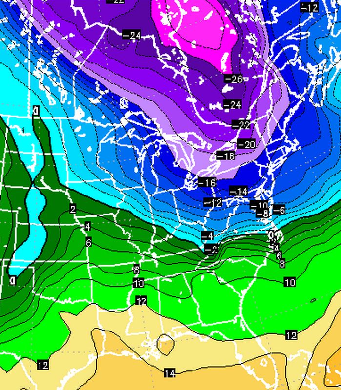
Cold for us isn’t impressive here. It won’t be at all during the new week. It’s just the chilly air that likely takes over the region right as we officially hit Spring on Friday evening. We are entering a time of year when we find the classic “Clashing of the Airmasses” There is still enough cold close to push deep into the lower 48 and shake things up considerably. Sadly, this isn’t the last or worst blast of cold air that I see this month. It could get even worse during the last 7-10 days in the month. During that time we could see multiple blasts of cooler air. This is something I have been noticing for a long time. Again… nothing unusual to see cool air that late in March or even into April. These shots could be pretty deep!
There I go talking about all of the cool conditions and I forgot to talk about the rain chances for next week. See how the cold gets my blood flowing. 😉
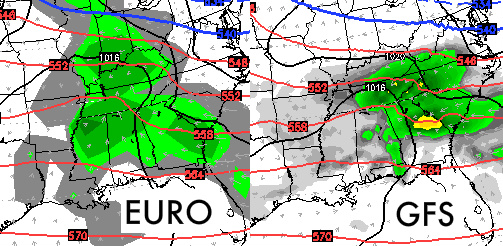
Now… keep in mind that the GFS is just now bringing any rain to our area for Thursday while the European has been picking up on that moisture for the past several runs. This begins our next rainy period for early Thursday morning and into Friday. Give the GFS a little more time and it will bring even more moisture into Kentucky. We all know it takes a little while to get on the right path. These will be some pretty chilly showers for all of us! Resolution of the models isn’t of concern here. It’s the fact that the GFS is just beginning to push moisture into Kentucky.
And just for fun… a look at the 850 temps for next weekend. One of s few cool shots see taking shape for the end of the month. This cold shot lingers for a few days too.
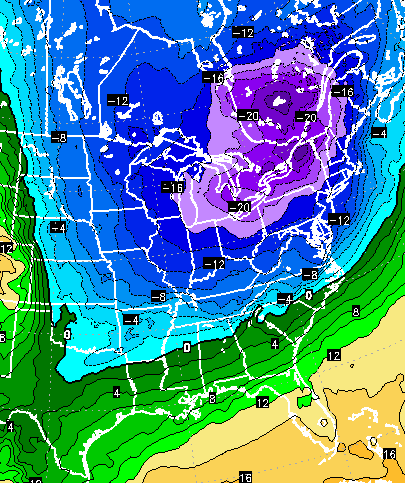 This pattern is still locked and loaded to bring even more cold down on us! Remember… this shot happens right after Spring begins 😉 Time will tell!
Enjoy the sunshine on this Sunday.
Take Care

Someone on the last post mentioned a new writing style. I didn’t comment, but I thought the same thing!
Reading this over a couple of times and my mind has entered the Twilight Zone, except this time it isn’t about weather, per se.
I’ve got to think for a while to formulate a response. 😀
I haven’t had the time to pay any additional attention to the writing style change until this morning. After I read today’s post it became clear that this isn’t him writing. Up until today, the change was just odd and unexpected. However, this morning’s post pretty much crystalizes that feeling you were mentioning.
This isn’t Chris Bailey writing it. It’s some kind of creepy impersonation by someone else. Forget the change here and go look at the past several days on his Twitter account. Barely any mentions of the SEC tournament and when you can find a direct response from the account it certainly sounds too lame to be him.
Two options:
1.) He’s gone on vacation and he’s taken a break from everything quite literally, and instead handed off the duties to someone he has entrusted with the task until he returns
2.) He’s trying something new and going completely out of character.
Which scenario wins?
I love conspiracy theories!
I read this over several times and It doesn’t have the same writing style as Cris. Maybe I am wrong, but something seems different about it…..
No big deal. But my bets are on Jim! He’s doing a great job, but it clearly isn’t Chris. I guess Chris just needed some R and R.
*Chris
The EURO may show a larger swath of precipitation, but its precipitation output is always blocky and overly geometrical. It reminds me of old Playstation 1 games where the graphics weren’t fleshed out.
Take the GFS, and it looks more like a PS3. It has more well-defined edges, shows heavier intensity areas, and has much better shading and gradient usage.
Both of the models do agree on the 540 line pretty well though.
So relieved that it wasn’t just me that thought this blog post sounded odd as far as voice and tone goes compared to “normal” CB. I thought I was going crazy!
Not looking forward to any below normal temps. Getting into spring mode and would like to see it stay warmer.
What’s the big deal about a few days below normal temps. Whether it’s 65 and raining or 55 and raining it is still raining.
I thought he went to Hawaii for several days. I remember seeing something about a tour he and his wife were leading??? I could be wrong, though.