Good Wednesday to one and all. Our super-duper stormy pattern keeps on keeping on. We have additional rounds of showers and thunderstorms on the way to the region over the next couple of days. Any storm that goes up could become severe and produce flooding rains. Sound familiar?
I really don’t have a whole lot to add to what I’ve been talking about for a while now. The rounds of showers and storms will try to fire back up today into the evening. Watch for some local high water issues and severe storms.
A cold front moves in Thursday night and that could provide us with the best risk for severe storms.
Things begin to dry out from west to east on Friday as cooler air moves in. That sets us up for another winner of a weather weekend with highs close to 70 under partly sunny skies.
Next week brings… wait for it… wait for it… more rounds of booming showers and thunderstorms. The GFS shows a ton of rain across our region through next week…
Let’s expand that out to include the following week…
 This is just a very stormy and ugly pattern that could set monthly and seasonal rainfall records in parts of the state.
Let’s do some Wednesday tracking…


Today’s risk area

Current watches

Possible watch areas 


Have a great day and take care.

I am glad to hear of no one being injured by the tornado’s in Richmond yesterday. Sounds as though we will be in a high risk area of strong storms with hail, heavy rains and possible tornado’s on thursday night into friday morning. I love that it getting warm now but we pay the price with strong storms. Everyone be careful as it won’t take to much rain to have the creeks and rivers to rise again.
No school for Knox due to high water
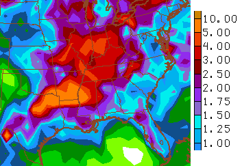
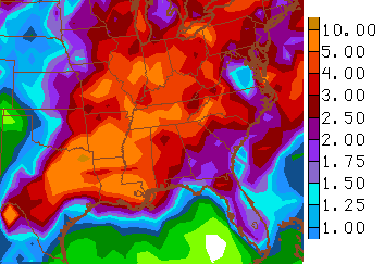
Can’t believe Lexington is standing at 7.15″ of rain so far this month. Louisville is at 8.03 which is enough for the 7th wettest April on record already! Not sure where Lexington stands ATM, but I can guarantee it is already or will be in the top ten. Some places in KY have had over 10″ and even some with a foot of rain so far! Plenty of time left in April and like CB stated, this could end up as one of the wettest Aprils and springs on record.
There were one or two brief and cryptic mentions during the winter of a hotter summer than the last few years. Depending on how long this pattern endures (not necessarily at this level, just above avg. rainfall), the upside may be that we keep that at bay. We shall see.
I thought I remembered CB mentioning something about hotter summer as well. But I also thought he backed off that later as he saw the pattern that was taking shape and some indicators. I might have read that somewhere else possibly however.
I figure as long as California stays bone dry we will stay in our pattern as well, which includes a not-so-hot summer.
Over 10″ of rain since Thursday for my part of Bourbon County.
My part of the county (Morgan) here has not seen the big rain for the most part. We did flood some but other parts of the county saw a lot more. Seems it all went to the northern part of the country and Rowan and along that line or south into Breathitt and things when it arrived here. Radar had a few big storms coming that split and poured to our north and south but we only had moderate to lighter rains. Yard is a swamp and creeks are high but cannot complain after going around other places.
Is the severe weather north the sever today? Or is there more severe coming later??
Sure there will be more. it’s that time of year, no biggie. tornadoes dont hunt people they just occur here and there….usually, there.
I just hope it misses Estill county until later tonight. I have to go to Lexington and my dog is terrified of storms. don’t want her home alone.
My cat is not only terrified of storms, but just rain hitting the roof too. Thunder is worse. Nothing you can do can keep him from freaking out.
I took mine to a dog sitter so she wouldn’t be alone, but there wasn’t any storms here, just some rain.
I love severe weather. I find the threat of severe thunderstorms and tornadoes exciting. I say bring it on.
To me, severe weather in the summer is far more interesting than winter weather. It saddens me that a lot of other people lose interest during the summer. Where’s the 300 comments a day during these types of systems?
This is the most interesting time of the year for me, with Tennessee/Kentucky basically being in its peak tornadic season. Kentucky Weather Center did happen to be extremely busy (both with blog visits and updates) during the March 2 2012 outbreak. Hopefully this at least in some small part saved a few lives that day.
Winter storms are interesting, but I’m not exactly a big fan of winter wx 😉 .
Summers in our area do have the occasional derecho which can get my interest; otherwise it’s more along the likes of garden variety t-storms with only a few relatively weak twisters.
Early fall has great wx to be in, but the dynamics that make that wx are not exactly exciting. But there is always watching hurricane season during this time 😉 .
2 more clusters of strong storms and torrential rain. Just hope that nobody is hurt. Outside of that I cannot help but enjoy. Especially at night with all the lightning. My young son has enjoyed as well. Splashing through the yard getting all wet and muddy.
Getting steamy sunny and muggy here in Southeastern Ky. !!
Humidity is high today. Took the God for a walk and started sweating. Love the warm weather but hate tornado weather. Scares me to death.
Took the dog for a walk.
sunny and 84 in London … never dreamed temps would be this warm in early April ….. looking like a hot summer.
Tornado warning for Bloomington IN, radar indicated; however, baseball-size hail reported in New Unionville according to Skywarn Spotter feed.
Interesting feature in Dubois county east of Jasper IN
http://twitter.com/StormTracker_4/status/585916057300422656/photo/1
Final Four Ref’s house
Not been as rainy as its been up north here in clay co but we have had lot rain . Sure has been muggy today. I got feeling my metal roof i put on back in early December will make it warmer inside, have use air more once i get it fixed. Compressor went out on heat pump. Repairman said probley be 1600 to fix it.