Good Monday, everyone. A strong cold front is working toward Kentucky today and will bring scattered showers and thunderstorms to the region. The storms of recent days have been a no show as the heat and humidity have stolen the show. That may happen today to some extent.
Temps ahead of our cold front will spike well into the mid and upper 80s across central and eastern Kentucky. Areas that have enough sunshine could hit 90 degrees. Winds will be very gusty and could reach 30mph at times.
Scattered showers and thunderstorms will be noted along and ahead of the front. This is NOT a washout of a day, and any storms that go up could contain hail and high winds. I will have your tracking tools in a bit.
Cooler and drier air moves in behind the front for late Tuesday through Thursday. Lows may reach the 40s with afternoon highs in the upper 60s and low 70s into Wednesday.
The models all bring an increase in temperatures and humidity by Friday with scattered showers and storms following close behind. The European Model is less robust with the rainfall numbers over the next week and change than other models…
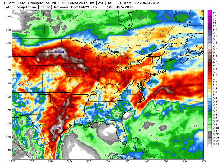
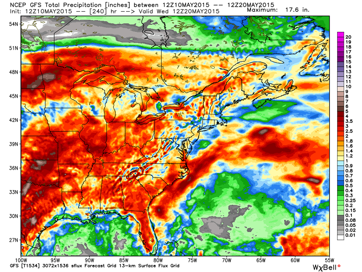
GFS
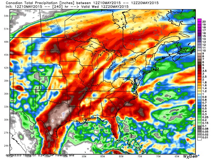
Canadian…
The European Model has had the hot hand with rainfall numbers of late, so let’s see if that streak continues.
In the meantime, track away..


Today’s risk area

Current watches

Possible watch areas 


I will have updates as needed. Make it a great day and take care.

It would be funny to have way way WAAAY above normal precip for the year and still be abnormally dry!
Anyway – about my Air Conditioning comment a few days ago. Yea- I’m pretty sure I’m the FIRST one in the neighborhood to turn mine on and the last to turn it off too!! My house does get full sun. A good example: In early April, it was a cool day but full sun with temps in the 60s. I had my AC set on 70. The temp only made it to 64 and I had the windows open, and around mid-afternoon, the AC kicked on!
And we just turned ours on a couple days ago. I was bummed. It was nice to not have any hvac going for over a month. We gets lots of sun, but when we built our house we invested in really good windows because of that. The sun can make a huge difference in the temp in the house.
When I lived at Chinoe Creek apts on the bottom floor, and there was this awesome view of the huge back yard, the AC didn’t run nearly as much because of the location of my apartment. The sun does make a HUGE difference. I wish there were large trees around my house!
Getting dry out there. Although the airport in Louisville had almost 0.40 Saturday morning, most areas have had no rain in over 10 days, and the last good soaking almost 3 weeks ago.
Its acting like its not even going to rain at all here.
Got really windy and brief heavy downpour in northwest Lex. I think we were literally on the very edge of the line..