Good Saturday to one and all. This is a very tropical air mass in place across Kentucky and that’s going to cause rounds of showers and storms to fire up. With the increase in juice, these storms will likely contain a lot of lightning(LOL) and will put down torrential rains.
While it isn’t a washout of a weekend, the storm threat appears to be a little higher than what I had thought a few days ago. Scattered storms will crank today through Monday and the latest computer model forecasts are showing some pretty decent rain totals.
Here’s the NAM through Monday…
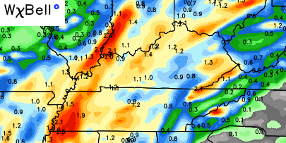 Models usually struggle with rainfall totals from thunderstorms. I suspect some areas could see locally higher amounts than what’s being shown.
What about the severe weather threat? A few strong storms could crank up through Sunday with hail and high winds possible. The best threat for a strong to severe storm may come on Monday ahead of a cold front moving through.
That front will bring much cooler and drier air into the middle of next week.
I have you all set to do some Saturday storm tracking…


Today’s risk area

Make it a great day and take care.

Not a fan of LOL. 🙂
Areas along and west of I-65 are almost completely covered by rain. I’d imagine east of there will get it this afternoon.