Good Monday, folks. We have a strong cold front working into the region today and this should touch off additional showers and storms. A few of the storms could be on the booming side with high winds and hail possible. Once the front blows through… cooler air blows in and takes control of our week in weather.
We will have to watch for the potential of some strong or severe storms trying to pop out there today. The best chance may wind up being in the north and northeast. I will have your tracking toys in a bit.
This front won’t move through until Tuesday and that means temps should still be a little warm with upper 70s to around 80 for many. Isolated showers and storms may linger across the east. Our boundary only slowly pushes to our south as cooler air sweeps in. The NAM has some downright chilly temps by Wednesday morning…
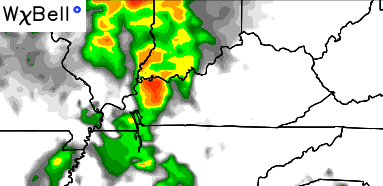
I mentioned the cold front being a slow mover. That slow push allows for a wave of low pressure to develop along it to our west and southwest. That system rolls eastward Wednesday afternoon and evening with an increase in clouds and scattered showers and some thunder. Here’s the future radar from the NAM:
 That system will weaken as it moves through our region, but some showers could linger into Thursday morning.
This is a cool air mass coming for the middle and later part of the week. Upper 60s to low 70s may be as good as it gets for highs during this time.
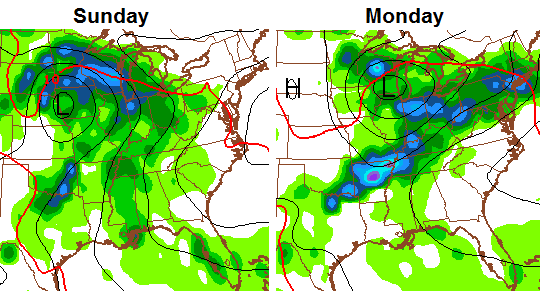
Warmer air moves back in as we roll into Memorial Day Weekend. Saturday looks like the best weather day with readings in the upper 70s to near 80 with partly sunny skies. A developing storm across the plains suggests things turn active by Sunday and Memorial Day…
Let’s track the storms in the short term…


Today’s risk area

Current watches

Possible watch areas 


Make it a great Monday and take care.

How I think about weather:
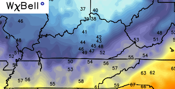
It was nice waking up to 69 degrees this morning.
It would be ugly waking up to 39 degrees Wednesday morning if the NAM were to verify. Ugh.
Our air conditioner quit working last Wednesday and thank goodness we haven’t had really hot weather. Ceiling fans have helped some but the house doesn’t feel all that hot thanks to lots of nice breezes. Just when the cool front comes through so will our new air unit. Once they install it I’m going to try not to set the thermostat as low. I sort of like having screens in the windows and am looking forward to the cool front..