Good Friday to one and all. We’ve made it to the unofficial kickoff to the summer season and things are looking more and more like, well, summer. Of course, anything is going to feel like summer coming off the chilly past few days.
Thursday’s highs were among some of the coldest late season numbers we’ve had around here in recorded history. That chill continues into the start of today with some upper 30s and low 40s possible.
Things begin to improve this afternoon as temps hit the low 70s in most areas. Some middle 70s will show up in the west and south as skies stay partly sunny.
Saturday’s weather looks great with highs pushing 80 degrees under more in the way of sunshine. Low to mid 80s still look to dominate the rest of the holiday weekend with an increase in humidity and storm chances. The best chance for storms will move in on Memorial Day, but I don’t expect a washout.
That increase in moisture from the southwest then settles into the region as we roll into the middle of the week…
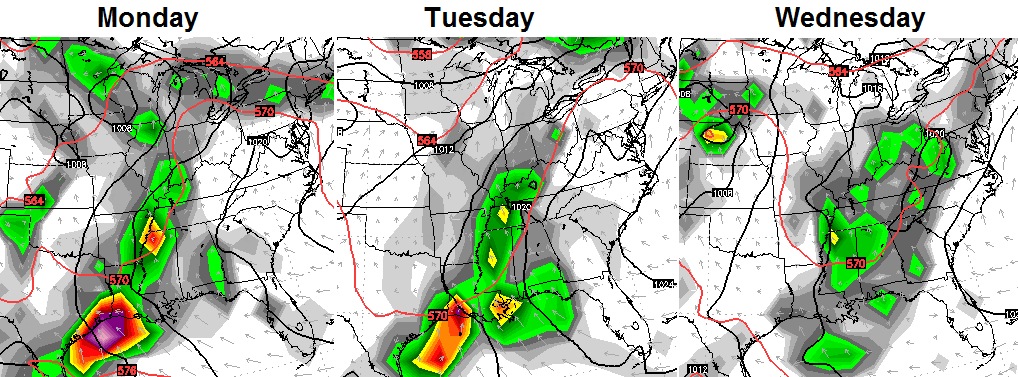
The pattern for the second half of the week into the following weekend is one that may be showing our summer setup. Notice how far out in the Atlantic Ocean this high sets up….
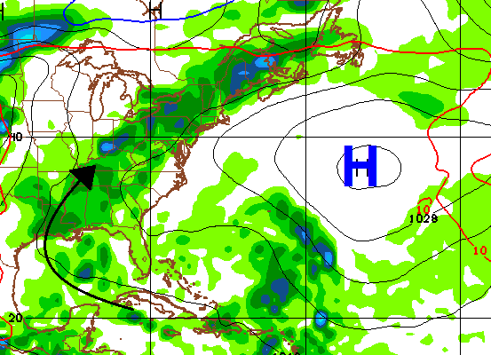 That puts our region in more of a very warm and humid flow that brings the threat for scattered showers and storms.
Since this weekend is the unofficial kickoff to Summer, it makes sense to look ahead to fall and winter! 🙂 I will show you some new seasonal computer model forecasts.
Enjoy your Friday and take care.

Leave it to good ole CB to go ahead and look at fall and winter before June gets here lol.
Thanks, CB! So ready for summer to come and stay 🙂 . While we didn’t quite turn on the furnace this morning, the electric heaters in the bedroom and bathroom came in handy.
– – – – – – – – –
For the third spring in a row, there has been a relative lack of severe thunderstorms (even if there have been some flooding issues) with only a small handful of EF0 amd EF1 twisters in our area. This of course is a big contrast from early 2012 and early 2011.
Not that summer is without risks like lightning, the occasional derecho, the occasional weaker tornado, heat waves, flooding. But at this point, we can perhaps breathe a bit easier regarding stronger tornadoes….if not let down our guard altogether. In recorded history, Kentucky and Tennessee have had no tornadoes F4/EF4 and stronger from roughly the last week of May until about November. Kentucky has had no tornadoes F3/EF3 and stronger from about mid-June until October (Tennessee has had some rare exceptions to this “rule” including an EF3 just last July).
http://www.srh.noaa.gov/news/display_cmsstory.php?wfo=mrx&storyid=98995&source=0
Another interesting tidbit is that despite frequent summer thunderstorms, Kentucky and Tennessee have had no July tornado fatalities in recorded history.
But on a more somber note, it was four years ago today that Joplin Missouri had its devastating tornado. Tornado season in the central plains peaks in May, but as touched on Kentucky and Tennessee are past peak for stronger twisters.
You forgot to mention down bursts. I hate those if you get under one.
Thanks Chris. Looks like a pretty good weekend in store weather wise. After the cool weather we’ve had this week I will certainly take it! Here’s wishing everyone a safe weekend. Please take time to remember those that made our freedom possible and those who have fought and served to keep it free. Happy Friday!
I guess that Japanese model is saying Blue over Kentucky again this fall/winter…
Thanks for considering our possible weather for next fall and winter. I am not even an amateur meteorologist, but I definitely like to consider possible weather patterns for a couple seasons in the future.
It’s amazing all the rain Texas has been getting. They were in serious trouble with their drought….and now they have flooding. But it’s amazing with flooding all around them, they are still in a drought. How? They have had over a foot of rain so far this month. Hopefully California will be next. It seems like they are always in drought. Have they ever NOT been in a drought in California?
Having spent the first 21 years of my existence in SoCal, I can honestly say that there have been a few decently rainy seasons among all the dry ones.