Good Sunday, everyone. We have scattered showers and thunderstorms getting ready to blossom across the bluegrass state. That’s what we have to look forward to for the week ahead. But, what about MUCH farther down the road? I’m glad I asked that question. 🙂
Let’s start with where we are now and roll way, way forward. Highs on this Sunday should reach the low and middle 80s with an increase in humidity. Isolated storms may develop with the best chance in the west.

Storm chances increase on Memorial Day and into Tuesday…
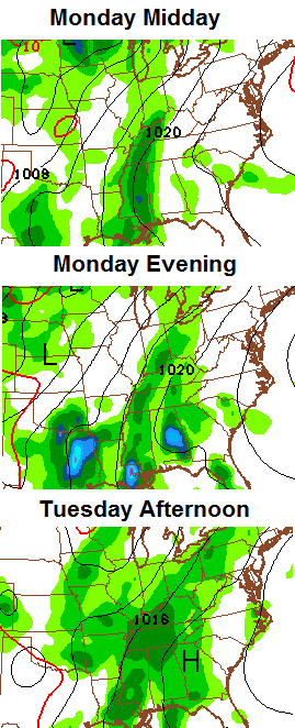
Scattered storms should continue into much of next week with the potential of some needed, and heavy, rains.
Let’s talk about the loooong range forecast from one of our seasonal computer models. This is known as the JAMSTEC and it’s one I’ve posted many times on here. I’ve found it to be pretty good in recent years, so I always look to see what is has to say.
The latest run just came out and shows something we already know… El Nino is coming on gangbusters out in the Pacific Ocean. As you know, all El Ninos aren’t created equal. Strength and placement of the warmest waters are the determining factors in the resulting weather across the United States.
This El Nino started this past winter and continues to strengthen and is likely to become strong by late Summer or Fall. Notice how the warmest anomalies get pushes from the South America coast back into the central Pacific…
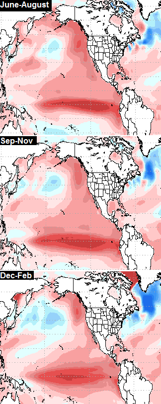
When a moderate to strong El Nino is east based near the South American coast, that spells bad news for winter loves across the country. See the winters of 1997/98 and 1982/83.
When the warm water is centered farther back into the central Pacific, we tend to see much colder and snowier winters across the country.
Now, check out the warm water in the Gulf of Alaska and off the west coast of North America. That’s been there since the fall of 2013 and has, in my eyes, been the catalyst in giving us back to back wild winters. The models all suggest that is STILL there through the rest of the year and upcoming winter. It promotes ridging into Alaska and western Canada, and allows for the jet stream to dip way south into the United States.
Given all that is showing up on the JAMSTEC, here’s what the model suggests for seasonal temps…
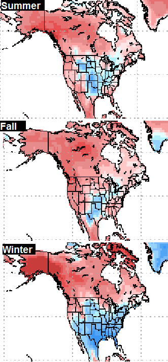
Can we make hit the trifecta of harsh winters ala the late 1970s? Time will tell, but the JAMSTEC certainly thinks so.
Have a great Sunday and take care.

It certainly looks like, given that setup, one large winter storm (at least) could wallop the TN valley.
Pretty neat stuff! Thanks Chris.
Happy Memorial Day to all the folks.
Thanks Chris! Long range outlook looks interesting but I am just gonna enjoy our current beautiful weather! Have a great Sunday everyone.
Cool Long Post!
No matter what happens next winter, at least we won’t have to listen to people talk about how big snows are a thing of the past here, considering what happened with 2 of the biggest snows EVER here three weeks.
Incidentally – Having a horrible AC addiction, I was planning on my electric bill to be outrageous, even though it hasn’t been terribly hot – I keep it on 70 F so it still runs quite a bit, and my electric bill was 107 dollars. I was so surprised it was that low.
What I am concerned about is the tendency for droughty summers in Ky whenever there is an El Nino. I remember the summer of ’99 especially. All our trees nearly died and there were cracks in the ground a couple feet deep.
You’re thinking about La Nina. 99 was a La Nina summer. El Nino tends to bring wetter summers our way. You will see that show up in my next post. 😉
Thanks CB for the info and the outlook. I remember the summer of 99 as a teenager. Our lawn was so dry, walking on the g*r*a*s*s sounded crackers being crushed.
We of course had a strong La Nina in 2011 and early 2012. This was a major factor in the m*a*s*s*i*v*e tornado outbreaks those two years in our part of the country, including March 2 2012 (West Liberty KY, Henryville IN) and much of the spring of 2011 (Georgia, Tennessee and especially Alabama hard hit among other states on April 27 2011, Joplin MO in May 2011).
Last but not least, thanks to all the men and women who serve/served this country!
Oh Chris…as interesting as this is, my mind can’t think about cold for a long time. Happy Summer everyone!