Good Monday, everyone. On this Memorial Day, let’s take a moment and remember those service men and women who’ve given the ultimate sacrifice protecting this great country. While we’re at it, let’s say a big thank you to all those who have, and continue, to serve our nation.
On a weather note, things are looking much more active this week and beyond. Coming off a soaking March and April, May has turned pretty dry across the bluegrass state. Even with the drier than normal May, to date, many areas are still on pace for a top 5 wettest spring on record.
That early spring wet pattern is showing signs of kicking back in as we roll through the rest of May into early Summer. The new CFS 45 day rainfall forecast shows what I’m talking about…
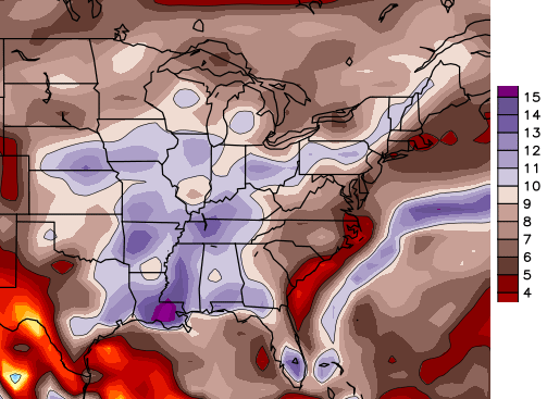
It’s shifting the corridor of heaviest rains from Texas and Oklahoma back to the east into our region. You can look at that map and infer a lot of deep tropical air across our region as the real heat centers itself east of the Appalachian Mountains. This looks like a super hot summer for areas to our east and southeast.
Back to the weather back in the bluegrass state. Scattered showers and storms roll across the state from west to east today. Locally heavy downpours and a lot of lightning (LOL) will be noted in the stronger storms. Keep that in mind for your outdoor activities.
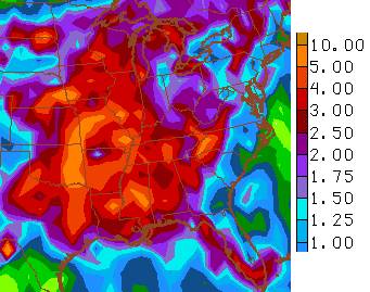
Rounds of showers and storms will become more common from Tuesday through the end of the week. A few stromr or severe storms will be possible. That action may continue into the weekend as a healthy cold front approaches from the northwest. The GFS rainfall forecast during this time…
Expand that out to the next two weeks…
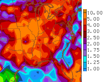
You can definitely see how the model starts to push the heavier rains eastward, ala the CFS.
I leave you with your tracking tools…


Have a great Memorial Day and take care.

Can we use LOL in our Weather reports on the WKYTwxWatchers reports?
Great question!
Yes! 🙂
Someone needs to make a series about alternate outcomes to historical battles if either side had access to accurate meteorological forecasts.
Hell, you should do it CB. You could enlist some students at WKU and UK to put it together. Do it really well and then pull in the awards and recognition for it. I can already hear The Voice of Reason cursing at the television in frustration and anger!
Thanks Chris. Glad we did our decorating on Friday. Guess we will grill between rain showers today. But it is getting dry so I will not complain. As we stop and remember those who gave the ultimate sacrifice on this Memorial Day, we have much to be thankful for. Freedom is not free. Someone paid the price. Have a wonderful day, and be ever mindful of those who served, and continue to serve.
This pattern reminds me of the doubt period we had a few years ago. The rain was always a day or two out and not much at all panned out beyond sporadic small area hits. Interesting to see if the case this summer.
drought
Well for a few there was always ‘doubt’ that their yard would get any rain at all and they were very vocal on here about it. Speaking of which, seems like I haven’t seen them comment since I started reading Chris’ blog again starting the beginning of April.
Sounds like winter lol
You can bet it’s going to rain in quite a few places tomorrow.
Bone dry in Harlan County! If the pattern does not shift soon, we should definitely be entering the abnormal/moderate drought category in this part of the state. We did not have a very wet April down in extreme SE KY unlike the rest of the state got saw; but March was wet here! I am watching the new drought monitor update this Thursday to see what happens…
Sorry for the grammatical error…take out got!