Good Saturday, everyone. A cold front is working toward the bluegrass state and continues to bring an increase in showers and thunderstorms. This front now looks like it’s going to actually push through the region and that means changes to the forecast.
Instead of keeping the very warm, humid conditions with daily rounds of storms… things are looking much better with cool temps and improving weather to open June.
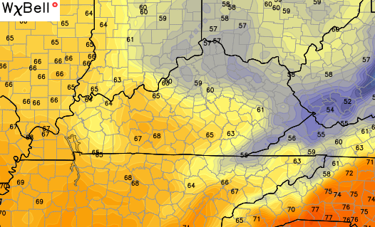
Rounds of showers and storms will still be out there today and Sunday as the front moves in. Some strong storms and heavy rains are possible along and ahead of the front.
Check out the push of cool coming in behind this for the first day of June…

GFS High Temps as we flip the calendar from May to June are a thing of beauty…

The same model run suggests some upper 40s would be possible by Tuesday morning…
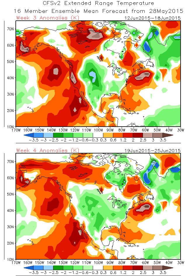
 The steam and storms should return by late next week into the following weekend. That probably won’t last too long as the global indicies suggest cooler than normal temps trying to take over much of the country. The CFS weekly forecast backs that thought up…
In the short-term… it’s all about the storm threat. Track on, my friends…


Today’s risk area

Current watches

Possible watch areas 


Have a great Saturday and take care.

Im sick of the cooler than normal weather… That is all!
I heard the equator is a nice place to live Virgil
I own a pool, I prefer hot, hot, hot weather. After all it is summer, bring on the heat!
I’m with Virgil and Jude, I too am tired of cool summers. After the last two winters, you folks should be sick of cool/cold weather. You folks need to a summer home in Maine if you want cool weather all the time. Us pool owners are getting jobbed my mother nature. Now, get us some hot weather in here and now!!!!!
To prove the old adage that you can’t make everybody happy, I’ll say that I’m perfectly happy with the cooler than normal temps. And since we need to replace our A/C this summer, this forecast will buy us a little time to shop around.
I like warm weather, but my wife likes milder conditions. Thus there can be some “discussions” about the thermostat!
The dog seems to be ok with most any weather, although she sure was reluctant to go outside during the frigid cold last February 😉 .
Although tornado season historically tends to be somewhat on the wane in our part of the country this time of year, the threat does shift elsewhere such as the Great Lakes and the northern plains.
Tomorrow marks a grim anniversary as it will be exactly 30 years since a large tornado outbreak in Ohio, Pennsylvania and the Canadian province of Ontario. Pennsylvania had its only F5/EF5 that has ever been recorded in that state, along with an F4 in the central part of the state that was so wide, the damage path was still visible on satelite photos decades later.
http://en.wikipedia.org/wiki/1985_United_States%E2%80%93Canada_tornado_outbreak
C B,
Thank you for all you do.
We really appreciate you!!
I’ve lived many different places in the us
you are by far and away the best wx guy!
Thx again!
Bring on the cool!
Thanks Chris. Don’t mind a couple of cooler days if it means sunshine. Don’t mind the hotter days either. Guess it doesn’t matter whether we mind them or not, as we are not in charge of the weaher, and as you tweeted last evening, you are just the messenger. . Oh well. Have a great Saturday everyone!
Bring on the cool. I hate heat and I don’t own a pool. If I did, I might feel differently – but whatever. My AC is on right now.
Whether the weather be cool, or whether the weather be hot.We`ll weather the weather whatever the weather whether we like it, or not.
So true and great weather rhyme C! I would like to have a fairly normal hot summer but, we do save energy when it is cooler; it is what it is!
Normal high for right now in 78. Prattle on more about how it’s supposed to be 90 right now so you can use your pool.
The only way these posts would seem more bratty is if they were tagged at the end with “sent from my iPad”.
True LD! If we were always exactly normal though, we would never have a real pool season nor snow in the winter in KY! With a winter average high around 45 degrees, snow would never have a chance in our state to lay on the ground or accumulate to a major storm except for briefly at night! There really is no such thing as a “normal high” or “normal low” which is nothing more than an average numerical value for all of the historical data gathered over time for a specific distribution of data!
Yep – it can be 100 degrees one day, then a front comes through and it’s 71 degrees the next day, then 85 the following day, then 90, etc. You take all those #’s and get the average temp……Big deal, right? Like that average temp means anything! It doesn’t really.
I’m need to get my spring hay cut and baled the first time we get at least three days of dry weather. A lot of other farmers from here in Rockcastle co. Are behind on the hay.
Please advise.
Thanks in advance.
LD be careful what you say, lest you be accused of trolling.
Har har har 😉