Good Tuesday afternoon, gang. Our pattern is about to become very active with rounds of showers and thunderstorms, and the heavy rain threat from Tropical Storm Bill.
Storms will fire up this afternoon and evening and could bring some very heavy rains with them. A few storms could even be on the strong side.
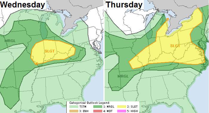
A better chance for strong or severe storms will come our way over the next few days. A cold front slows down across the region and that’s the focusing mechanism to get the storms to fire. The SPC has much of the region in the Slight Risk area…
Damaging winds and large hail will be the usual main suspects.
With so much tropical moisture in place… local flooding problems will be a strong possibility. Remember my word from last week about this week? Cloudburst.
This brings us to tracking the leftovers of Bill. Our Tropical Storm is coming ashore across Texas and will lift north through the Mississippi Valley and then turn eastward into the Ohio Valley. Add the NAM to the growing list of tacking the leftovers across Kentucky on Friday and Saturday…
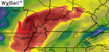
That’s a map similar to the one I posted last night from the GFS. That’s a TON of deep tropical moisture that could produce a lot of rain for areas along the track. We will really have to watch for that possibility in the coming days.
The brand spanking new Canadian Model has a very ugly look for our region…
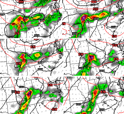
In the short-term, let’s track the increasing amounts of showers and storms we have out there today…


Today’s risk area

Current watches

Possible watch areas 
I will have a full update on WKYT-TV starting at 4pm. Enjoy the day and take care.

Thanks for the update Chris. Rain would be good but we don’t want too much of a good thing, which seems entirely possible over the next few days…..
One of these setups to where some folks get a ton of rain while other’s don’t get enough.
Truth.
Yes-had a 3-5 minute shower yesterday in my part of Georgetown. Today’s storms have danced all around us and missed.
Bailey you are the man. Thanks for the update.
And I saw rain. It was down the way on the hill. It was falling heavy but nothing here. I was wondering what was going on. The rain line just did not get here. Sun returned to the sky.
Then I was looking out the window at the next storm rolling in. Figured it would miss. Not this time. The rain started all of a sudden. Heavy for about 20 minutes or so. Not a huge rain yet but was real nice to get. Some is better than none.
Everybody have a great rest of the day.
And day number 7 in a row with 90+ degrees officially for Louisville.
I don’t see anything ugly about those maps considering some areas need rain badly. The latest long term Palmer Drought Index has most of central and eastern KY in moderate drought now. Yep, the wet spring is a thing of the past. Bring on Bill, we need it.
Nope
🙂 Come on CB, the blog has to have some drama! 😉
Come on Chris, I respect your skills as a meteorologist (and love the info you provide here), but the last 7 weeks have been very dry for some areas. Yes, it happens. It’s summer. But, some credit has to be given to the drought indexes. They aren’t made up. Does that mean everyone in the moderate drought area is dry? Of course not. But a good, soaking rain would not be ugly this time of year.
Darn! This kind of destroys any drought talk now 🙁 😉
After the little rain I was really hoping it would get going at some point. And sure enough it rains a very nice rain. Will probably have to mow this weekend now. Been a little break from that. And no need to keep watering the gardens either for a little bit.
Looking forward to seeing how this plays out with those leftovers over KY. Leftovers can sometimes be a good thing.