Good Wednesday, everyone. Our active weather pattern kicked into high gear yesterday with rounds of strong and severe thunderstorms. We’re likely to see additional rounds of big boomers over the next couple of days. After that, we will focus on what’s left of Bill and how it may bring significant rains our way.
In the short term, its’ another steamy day with rounds of strong to severe thunderstorms developing. Here’s what to expect in order of likelihood:
– Torrential rainfall that could lead to local high water
– Dangerous cloud to ground lightning
– Damaging winds
– Large hail
I will get your storm tracking toys on in a bit.
A similar setup will be with us on Thursday and that means another day of possible strong to severe storms. The same threats should also be noted.
What’s left of Bill should begin to impact our region on Friday and continue into Saturday. Odds favor showers and storms on the increase and this action can put down a lot of water. The latest data still shows what’s left of this moving across our region…
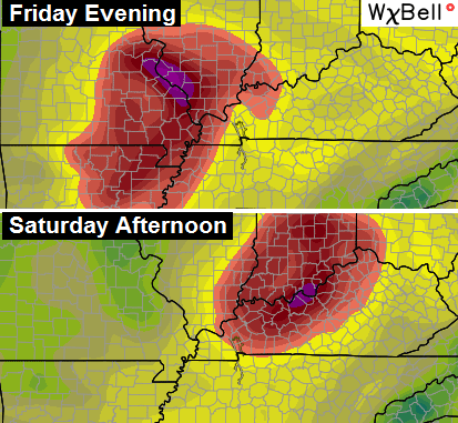 High water issues could become common as what’s left of Bill works across our part of the world.
Beyond that… Sunday looks hot and humid with the potential for a round of storms coming from the northwest. That pattern really takes hold early next week as the heat ridge pushes into the southwestern part of the country…
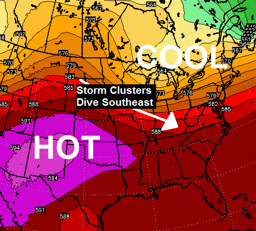 The early stab at next week would feature hot and humid weather returning by the second half of the week. Hottest of the entire summer? That shouldn’t last very long… After that, watch for a deep trough to try and dig into our region.
Let’s do some Wednesday storm tracking…


Today’s risk area

Current watches

Possible watch areas 
I will have updates as needed. Take care.

Thanks Chris. We got some rain and thunder yesterday, but we were not in the line where the storms kept training. It did cool off the temps somewhat. Humidity was and is off the charts though. The trough you are talking about moving in next week or just beyond, cooler temps but not unseasonably cold, right?
Have a wonderful Wednesday everyone. Stay safe.
We are driving back from Pensacola on Saturday. Praying the weather is good. Thank you Chris for all you do!
Just like winter in Kentucky most of the time. It either goes to the north or south of us here in Taxington.
Pat – no it doesn’t. It just seems that way sometimes…..Not sure how you could possibly say that after last year. LOL
Last year was an exception for winter Mark. I’m just saying the rain and storms usually go north or south of Lexington.
Ever notice that know matter what city you live in the commonwealth someone will say the storms rather it be rain or snow goes north south west and east of them.
Prelude, I’m not trying to dispute Chris or any of the weather people on here. I’m just saying that earlier this week they were calling for a boat load of rain. I live in south Lexington and there has been a trace of rain at my house. Now go down to Richmond and they have received a bunch of rain, same way with Scott county. It just seems to part the weather, rain, as it leaves Louisville.
Pat, by no means am I picking on you. I’m just making a comment about how we including myself feel that we get the shaft where we live when storms don’t pan out. Example, I live in Louisville and when a forecast bust, us weather geeks in Louisville blame southern Indiana for taking our storm it seems to happen alot. You ask the folks in Bowling Green and they say Louisville always gets the better snows or t-storms. You asked the folks in London KY and to them Lexington always gets the good stuff. Ask folks in Lexington, and Cincinnati always gets the better storms. So on and so forth.
My mom in Texas is mad that she is on the low end of the Bill rain totals. She was expecting 6 to 10 inches but got only 3 inches as of noon. She does not need rain, but it was forecast and didn’t happen, so she’s mad.
Bill isn’t that impressive really. Yeah be a few inches of rain like you said but hardly the 10-12” some were saying.