Good Thursday, everyone. Rounds of heavy rain producing showers and storms continue to push across the bluegrass state. This action is setting the stage forheavier rains coming from the leftovers of Tropical Storm Bill. It continues to look like that system will track right on top of Kentucky.
Storms today can be on the strong side with some local severe weather possible. The main threats will be from a lot of lightning (LOL) and torrential rains. The rains could lead to local high water issues developing.
Rounds of showers and storms will get more of a tropical punch later Friday into Saturday as what’s left of Bill rolls on top of the region. The core of the system shows up very well on the precipitable water forecast map…
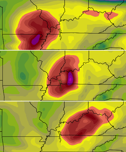
There has been no change on the model track of the core of this system. The only change is the precipitation forecasts from the models are finally catching up. Those forecasts never matched up with what the core of the system was actually doing. That’s why you never saw me write about them or tell you everything would miss us to the north.
As it stands now, Saturday into Saturday night could get interesting as that core passes right on top of us. The rain shield and storms with this system may actually increase during this time and that could cause some issues. Obviously, flooding would be possible if things play out in that fashion.
After that passes through, temps head toward 90 for Sunday with storm clusters cranking from the northwest. That setup could send some big time clusters of strong and severe storms in here into early next week.
The second half of the week may feature the hottest temps of the entire summer around here if storms don’t get in the way (and that’s possible)…
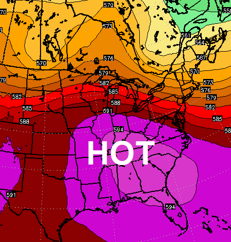
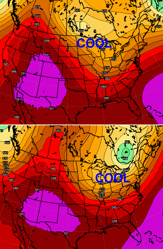
That’s a transient heat ridge which would only be around for a couple of days. Look what replaces it a few days later…
 As usual, I have you all set to track today’s storms…


Today’s risk area

Current watches

Possible watch areas 
I will have updates later today. Have a great day and take care.

OK, so a transient heat ridge as opposed to what other kind of heat ridge? Shows how much I know!
Oh, and to follow up on the comments from the last post – Since reading comments over the years from people all over the state posting (including myself) about how their area gets missed. But I’ve noticed other areas get missed as often as my area….it evens out eventually…..So I agree with prelude.
The forecast seems great and all except for the areas that that need the rain the most now in SE KY; we are only suppose to get up to an inch:( We are now in moderate drought down here: http://droughtmonitor.unl.edu/Home.aspx
CB,
It seems such a large scope of the country with a hot air to cool air transition could be ripe for weather troubles in that period.
Thanks Chris. Looks like we are in for a good dousing from Bill tomorrow night and Saturday. While there are some parts of the states who have not had a lot of rain of late, those that have don’t need a possible 3 inches, and those who need it don’t need 3 inches at one time. Looks like the possibility of heavy rain could be bad on either count as it could cause flooding.
Gosh, I sound like a weather weenie! 😉 Seriously, enjoy today and have a good time outdoors. Looks like you may be stuck inside from tomorrow evening until Saturday night, at least! Happy Thursday!
Thanks again Chris, for all you do!