Good Thursday afternoon, gang. Things continue to come together for a heavy rain event across much of the bluegrass state in the coming days. Rounds of heavy rain producing showers and storms will be the opening act for the remnants of Tropical Storm Bill.
This system will work across Kentucky late tomorrow into Saturday and could bring a deluge with it. I’ve highlighted the areas at greatest risk for seeing, at least some, flooding problems…
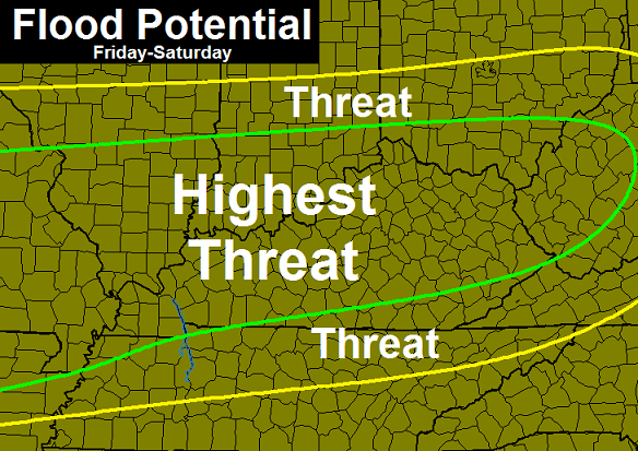
That doesn’t mean everyone in those areas will see enough rain to cause flooding, but it shows the areas with the highest threat.
Folks with the WPC are finally figuring out this system is not going toward the northern Ohio Valley and Great Lakes…
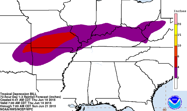
Before the remnants of Bill move through, we have to really be on guard for some local high water issues from storm clusters. These clusters will develop later today and could really kick in tonight into Friday morning. A few of these storms may also be strong or locally severe.
Rounds of strong and severe storms may follow Bill late Sunday into next week. This is a very stormy pattern that can put down way too much rain around here in the coming week and change.
I have you all set to track today’s action…


Today’s risk area

Current watches

Possible watch areas 
Updates as needed. Take care.

Thanks for the update Chris. Be looking forward to seeing you at 4 on KYT.
I feel for the folks that have to get out and work in this humidity all day everyday.. Construction workers, roofers, etc. etc. Disagree if you want but this is worse than bitter cold temps in the winter. At least in winter you can bundle up and it’s not so bad. If you work indoors you may not understand, but go out and work on a roof all day, or cut weeds, or pour blacktop on the highway all day and you might see things differently.
I work outdoors plenty of times as a paramedic and much prefer wiping sweat off my forehead. In winter I still break a sweat and have to deal with constant switching from warmth to cold, which can cause serious shock to my system.
Winter i can bundle up but only so much i can take off to stay cool . I can see noth jason and jeff’s,way of thinking tho.
I hate extreme cold as,my bones hurt , especially my hands. Only way i csn warm them up is run hot water and put my hands under it.
On other hand i cant stand to get way too hot.
Nws jackson says no break in this summer patern in long range forcast. Was hoping muggys would let up few days.
Parts of north-central and eastern Kentucky are in a “moderate” drought now.
and it’s 100% BS
LOL @ Chris!
Yea… Lexington is in a moderate drought according to our Government folks… all while running 6″ above normal for the year. Unreal at what they classify as a “drought” nowadays.
So are you saying the drought in California is bs because of what the government drought monitor says?
Do you remember 1999, Chris? The first half of the year started out wet. Louisville was about 6 inches above normal for the year by the end of June. By July, the rains stopped, and the heat set in. By October, a lot of areas had only seen an inch of rain (or less) total over the previous 3 months. The worst “short-term” drought I have experienced. Large trees died because of the lack of water and heat. So you will have to excuse folks, like me, who worry about drought when the rainfall total over a 7 week period was only 1.50 inches, or about 25% of normal.
After the last 2 days, I would declare the short-term moderate drought over. I have seen almost 3 inches at my house, and I will gladly take more. Give me heavy rain over no rain any day in the summer.
Creeks that always run all year are now dry in Knox
I should have said some creeks.
But no drought exists because it rained a lot 3 months ago. 😉
M-a-s-s-i-v-e rains in northwest Lex, but not a LOL strangely!
I had to attend a meeting this evening from 6:30 to 7:30 in southern Lexington. I guess it was around 7:00 the sky got very dark and for bout 10 minutes the wind was blowing so hard even the evergreens were bending.
With all the rain coming in for the weekend I’m wondering why no Flash Flood Watches haven’t been issued?