Good Saturday, everyone. What’s left of Tropical Storm Bill is working across Kentucky and bringing quite a bit of rain with it. This rain, combined with recent heavy rains, will lead to an increased flash flood threat today into this evening.
The swirling bands of showers and storms will continue to be impressive on radar. These bands of storms can also spawn a quick tornado spin up, but the chance is fairly low.
A general 1″-4″ of rain (from Friday through Today) is likely across the state, but higher amounts will be possible under the core of the system. That would be more than enough to cause some high water conditions to develop. Of course, this does not mean everyone will see flooding!
You will also notice gusty winds out there today as this tropical depression passes over us.
I have a full discussion on where we go from here, but I want to put all the tropical trackers on here first…


Today’s risk area

Current watches

Possible watch areas 
What’s left of Bill will scoot out of here this evening. This sets the stage for a very hot and humid Sunday with clusters of thunderstorms working in from the northwest. Severe weather is a possibility into Sunday night and Monday.
These storm clusters can continue to cause issues through the end of the week…

A strong cold front looks to sweep in here by Friday and Saturday with some potent thunderstorms. That also should be the beginning of a MUCH cooler period. Check out the big dip in the jet stream showing up next weekend…
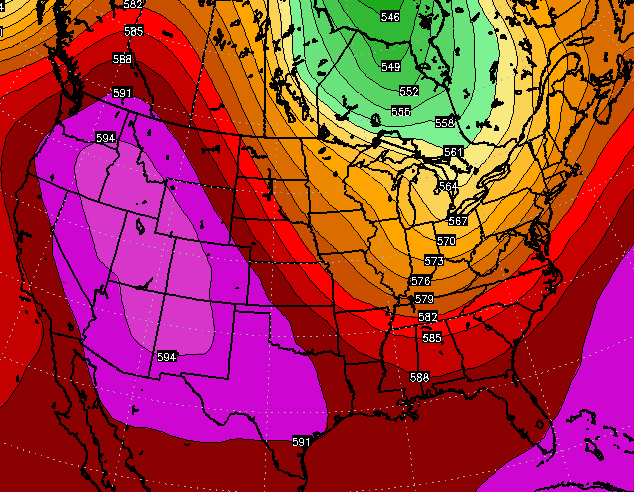 That setup looks to continue into the final days of June and into early July…
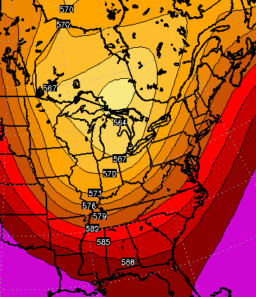
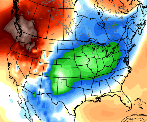
The European Ensembles first 5 days of July show much cooler than normal temps for much of the country…
 I will have updates on today’s flooding potential as needed. Have a great day and take care.

Almost 4 inches so far in my part of Bourbon County since mid-week.
We will all relish cooler temps for all the mowing we’ll be doing.
We’ve had about an inch since midnight here at our house. Windy here this morning too. Most of the heavy stuff missed us here yesterday. I ask again Chris, when you say cool temps, are we talking 70s or cooler than that? Have a great Saturday everyone. Thanks Chris for all you do!
I’m not CB by any stretch of the imagination but 70’s look like a good bet for highs for at least a few days for the first week in July.
As someone who had to be outside today…
http://i.imgur.com/TGBvBV1.webm
Looking at the radar it looks like its developed a small eye over lexington
So I am confused…is Bill technically a Tropical Depression or just a remnant low or something else at this point? I’ve seen the system called multiple things so far today.
Still a depression… 4 days after making landfall. Unreal.
According to my math, over 2 inches of rain in Lexington (at least at the airport) since yesterday, which will bring the total for the year to almost 30 inches. Averaged out, that’s 5 inches per month so far this year.
DROUGHT! 🙂
Well Chris, I love your site and have been here many years. However, many areas still have seen drought like conditions since the end of April. Lexington has been socked by rain the last several days, but many other areas especially parts of southern and eastern KY haven’t seen much rain. Here where I live, just north of Somerset, I think I’ve had a total of maybe 4.5 inches since April 30th. 2,5 inches of that total coming this week. It’s not been a Tropical rainforest like Lexington.
Hi Joseph and thanks for the kind comments. It’s not just Lexington… every single official reporting station in Kentucky is above normal on rainfall for the year. A dry period does not constitute a drought. Take care.
“Covington” likely went from negative back to positive on yearly rainfall just today. I’m with you on the drought thing though. When crops start failing that is when it is time to worry IMO.
Did I say something wrong? Just pointing out not everyone had the rain others have experienced.