Good Sunday and a Happy Father’s Day to all the dads out there. The big day will feature another round of strong to severe storms diving in from the northwest. This action comes on the heels of a drenching rain courtesy of Tropical Depression Bill.
Bill is off to our east, but left behind a lot of awesome stats…
– This was still a tropical depression as it crossed Kentucky… Some 4 days after making landfall in Texas.
– This was the first Tropical Depression to make it all the way into Kentucky since 3 storms did it back in the busy 2005 hurricane season.
– This was one of the only times on record the center of circulation of a tropical system passed over the Lexington metro.
– Much of the region picked up 2″-5″ of rain from Thursday through Saturday. Officially, Saturday gave Lexington the wettest June 20th on record with 1.8″ of rain.
Fast-forward to today and we find more storms set to impact the region. A few clusters of strong to severe storms will dive in from the northwest. These storms may produce damaging winds and large hail. Torrential rainfall could cause some local water issues.
Get used to the rounds of storms…
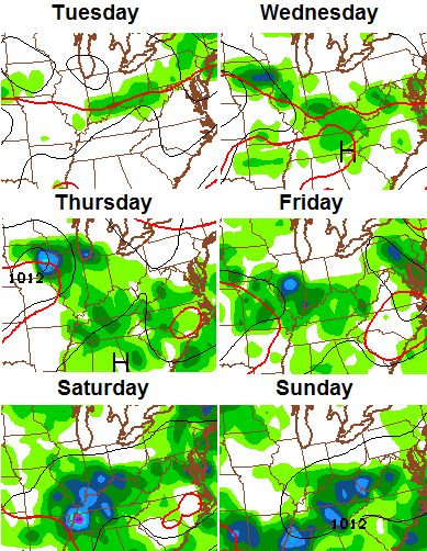
Storms in that hot and humid environment can drop a lot of rain and produce some wind damage. Be advised!
The heat and humidity gets ready to take a hike to the western part of the country starting next weekend. That trend looks to continue into the week leading up to the 4th of July…
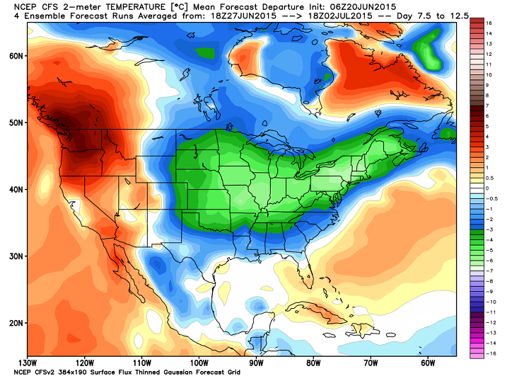
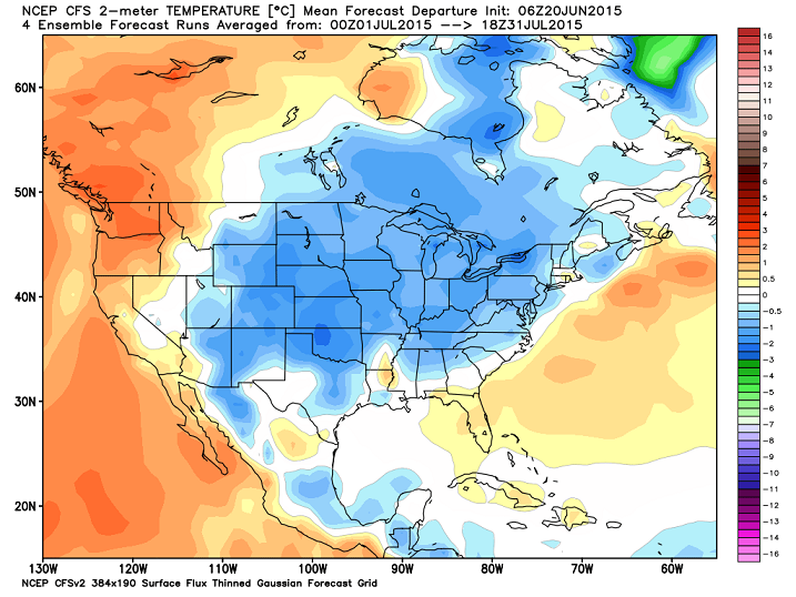
The CFS is painting a similar view for July as a whole…
I leave you with today’s storm tracking tools…
trackers on here first…


Today’s risk area

Current watches

Possible watch areas 
I will have updates as needed. Take care.

Thanks Chris. Looks like you can put the forecast on repeat for a few days. Still hoping that Friday starts out without rain. Hate traveling in rain. Ah well this is Sunday. One day at a time.
Happy Fathers Day to you, Chris, and all the dads out there! Hope you ALL get pampered as much as you deserve! Happy Sunday everyone.
Oh yeah, and remember this is the longest day of the year!
I echo Coffeelady’s thought’s about Father’s Day, even if it could be said that everyday is Father’s Day and Mother’s Day! My parents had the right idea as they are on vacation, they deserve it! My wife and I are headed to Bowling Green in a bit to see my in-laws and celebrate Father’s Day there.
Wow, the conditions yesterday really did remind me of the several tropical storms/hurricanes I went through in Florida. I felt like I was in FL again with all the heavy rain and wind, but I’ve seen worse. Does anyone know if a tropical storm has ever made it this far inland into Kentucky before?
Sometimes the Gulf Coast ones head north right to us. Once every few years.
Hurricane Camille came over Lexington as a tropical storm in 1969 after it devastated the Mississippi Coast as a Cat 5.
Hurricane Ike back in 2008 left North Central Kentucky a mess 70 mph winds with a 90 mph wind gust played havoc in Louisville. Over 60% of Louisville was without power some as long as 2 weeks. It was a complete wind storm that lasted for hours with zero rain that fell.
I was a recent college grad that moved to Evansville IN (after Ike) but people there were still talking about the mess Ike left behind. Then I directly experienced the 2009 ice storm in Evansville; it was bad enough in my area although the worst icing was to my south.
This all was after yet another big wx event; I nervously monitored the so-called Super Tuesday tornado outbreak of Feb 2008 during my senior year at WKU. Bowling Green was spared, but other parts of KY and TN were not so fortunate.
Thanks for the reminder on that one. It’s always good to cite historical examples versus whatever the current hype-fest is weather wise to keep things in perspective.
I’ve never heard that mentioned before here. I didn’t know we had any connection to Camile.
Thanks! 🙂
Summer solstice officially starts at 12:38pm today. It’s hard trying to enjoy the last few hours of spring when it’s so muggy out. Anyways, I will be mad (not literally) if it cools down after this weekend. I am off to Florida this Saturday and there is a 0% chance it will be cool and not humid down there. I hope the cool weather stays here long enough so that when I come back, I could get a relief from the FL heat. I won’t come back until July 11th.
Dew point of 83 in Todd county? Holy swampy air batman. You will get wet just by walking outside. This is about as sticky as it gets around here.
Try 85 degree dewpoint now if that’s accurate that’s incredible
So last night I took a look at the radar at the time this huge line of storms moved right through Indy. Today, I looked to see how much rain they received and only .27 of rain. WTH?
I saw that line of storms last night also. Is just me or are the storms weakening? If so where the storms for today come from? Radar looks clear for most of us.
They probably come from outflow boundaries from old dying storms, and instability in the atmosphere from heat and humidity. They can just develop from nothing. The radar may look completely different this evening than the boring sight that it is now.
I was just surprised that last night that healthy storm moved across Indy and only dropped a small amount of rain. Even if it was moving fast.
SPC may issue a watch (60% chance) for much of KY and extreme northern TN. As CB touched on, damaging winds and large hail would be the threats with the highest risks. However, the SPC still gives a low chance (2%) of an isolated twister.
Indeed, a Severe T-Storm Watch has just been issued for south central and south eastern parts of KY, as well as for areas of Virginia and West Virginia.
I’m getting married next weekend, I really hope it doesn’t rain 🙁 but I’ve heard if it rains on your wedding your marriage will grow strong haha
Wishing you the best. I had an October wedding that was sunny, mild but rather windy – whatever that means 😉 .
Thank you! That was originally the plan was to have the wedding in October last year but family medical stuff came up and couldn’t. Outdoor wedding would’ve been perfect in October but of you have one you’re really just taking a chance on the weather.
Earlier this afternoon, the difference in how the air felt between Hamburg in Lex and Berea was ridiculous. I don’t know what the actual numbers were at the time but it felt like a comfortable ocean breeze at Hamburg and then like the Amazon in Berea 40 min later. This afternoon felt like the most oppressive air yet so far in our early summer and in my recent memory.
As far as July being below normal, let’s see what happens. I believed the whole thing about June being below normal and we all know how that worked out. It will be interesting to see just have warm June can come out numerically. Forget the highs, the lows were +7-10+ degrees above normal every day, so it has to come out looking pretty bad. It’s also interesting the lack of discussion from the mets when we’re dealing with such warm temps versus the opposite situation. If we were running the same differentials on the cool side each day, all you’d see would be “Oh my gosh folks, another AMAZINGLY COOLER than normal day out there….” lather, rinse, repeat.