Good Monday, everyone. Our stormy period rolls on across the commonwealth of Kentucky. These storms will be rather frequent this week and should bring additional heavy rains to go along with a severe threat. The increase in the action is because of a change to a cooler pattern that is already underway. You’re just not going to feel it until the weekend and next week.
Today should feature a storm or two out there, but this looks to be the driest day of the week. Thunderstorm chances will really ramp back up on Tuesday when another round of severe storms could come calling.
Get used to that… storms will be very common for the middle and later part of the week and that should take us through the upcoming weekend. That’s when a strong system digs in from the northwest…
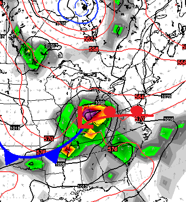
That could be a decent severe weather maker across our part of the world. There’s also the chance that system stalls across the Ohio Valley or another system could dive in and take its place. With a big heat ridge developing in the west and a deep trough digging into the east, the chance for a lot of rain continues to be with us. The two week model rainfall forecast…
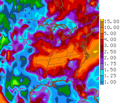
Don’t take the exact placement and numbers to heart, but do listen to the overall theme of the models… stormy!
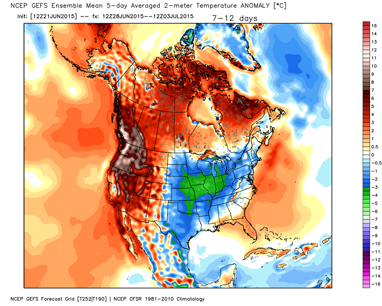
Another trend is toward cooler, and potentially much cooler. The GFS Ensembles as we close out June and say hello to July…
I leave you with your daily dose of tracking tools…


Today’s risk area

Current watches

Possible watch areas 
Have a great day and take care.

Did you see thst noaa report saying this may was hottest may ever and it wasnt a fluke? Way i read it, there trying to sell global warming junk again.
Weather is give snd take
. It cools down, then it warm up. It warms up , it cools down.. balance . I agree with a certain competition on that one. Heard him say its balance before.
Anywaya, look foward to cool down. First part of warming up oeriod has had me HOT!, ive had no air except a fan in the window until last Thursday. I got a window unit till i get my compressor fixed on trane unit.
Lot rain potential. Be good on garden, but wind and hail could ruin a garden. Lets hope not.
Ill try keep my ham radio handheld chsrged up on case i need to call in storn reports .
Thanks chris for all you do for us weather wennies.
Being told the ‘where’ part of why a mystery occurs (see above), can often times save the frustration of trying to determine the “why” of it.
Ummmmm what????
A brief wind event lasting only a couple of hours in parts of the upper Midwest had crazy non-thunderstorm winds wrapping behind a small scale low pressure area. I saw one recent observation from Worthington, MN about an hour ago that had sustained wind of 56 mph and gusts of 74 mph with partly cloudy skies noted. Most locations were getting 40-50 mph non-thunderstorm winds.
The warming climate theory i’m still little skeptical about it. The climate comes in cycle.
I’m also still somewhat undecided about climate change, even though I have changed my mind on other scientific issues (I’m a former “YEC” creationist; I now reject both the young earth and world wide Flood beliefs I grew up with).
Glad to know I’m not the only one.