Good Wednesday, folks. Some areas are getting in on a breath of fresh air today with cooler temps and lower humidity levels. The oppressive stuff moves back in quickly for Thursday and sets the stage for some big storms. These storms may increase into the start of the weekend as we await the arrival of a much cooler pattern.
With a front just to our south, temps will come down into the low and mid 80s for highs into parts of central and eastern Kentucky. Humidity levels will be much, much cooler. The same can’t be said for the west and far south. There is still a small chance for a shower or storm, but most areas look to be in decent shape.
As I sated last week, Thursday has the chance to give us the hottest weather of the entire summer. Low to mid 90s will be possible if we keep the sunshine. Heat index values of 100-105 may be common. Our saving grace could be the gusty winds.
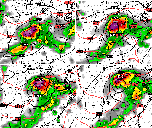
Strong to severe storms would then be possible late in the day into Thursday night. Thunderstorm clusters will dive in from the northwest and these could be damaging wind producers.
Friday into Saturday continue to look very active as low pressure moves across the area…
Heavy rainfall and additional strong storms would be possible ahead of that type of system. Much cooler air then spreads in from the northwest. Highs from Sunday into early next week may not get out of the 70s for many areas.
Another system would then dive in by the middle of next week and could deliver more heavy rains. The European Model continues to advertise some big rain amounts from these two systems…
 As usual, I have you all set to track whatever weather we have going up out there today…


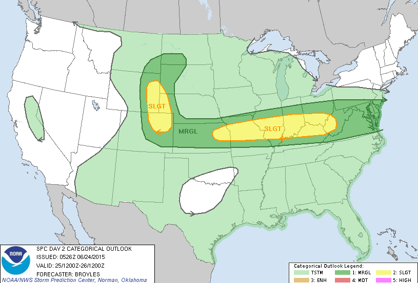
Today’s risk area

Current watches

Possible watch areas 
Have a great day and take care.

Sunny and cool the morning. Should hit about 72 and remain sunny today… Oh, that’s the forecast for north central England where we are now. We Hope to bring this weather with U.S. when we head back to Kentucky next week…
http://twitter.com/Kentuckyweather/status/613520752588013569
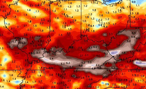
This tweet was at 6:35 P.M on Tuesday. Dew points close to 12 hours later and relatively unchanged as far movement. Madison currently rocking 65 dewpoint and 94% relative humidity. That is one slow moving block of drier air!
Pic from Fenway Park in Boston during their tornado warning yesterday. Seeing a lot of these apocalyptic looking skies taken at baseball stadiums recently. Odd trend.
http://i.imgur.com/rG5X9gc.jpg
Still checking the weather pretty much every day. Just like back in the winter. Thank you for keeping us on top of things so these storms that pop up are not a surprise.
The cool down is coming on the same day I leave to Florida on Saturday. Perfect timing….. Oh well, the weather won’t be the first thing on my mind over there anyway. Haha
With an area wide 2-4″ possible through Saturday, Louisville may break into the top ten wettest June’s.
Still need just a smidge over 2.25″ for the rest of the month.
How bad is tomorrow going to be? Anyone have an idea? thank you
I know there is an enhanced risk (which is about slight risk) for severe storms over a lot of KY, but from what I’m reading, it’s during the evening and night not the actual DAY tomorrow.