Good Friday, everyone. Strong and severe storms rumbled across the bluegrass state Thursday and more of the same can be expected today. If anything, the severe weather threat looks to be even greater later today into the evening.
A developing storm system will roll across the region from west to east through tonight and Saturday. This is a potent storm that doesn’t look like something you see during the summer months. Rounds of showers and storms will be common ahead of this system today.
As the area of low pressure deepens later in the day, expect the threat for severe storms to rapidly increase across the entire region. The Storm Prediction Center highlights our region for the greatest chances for severe weather…
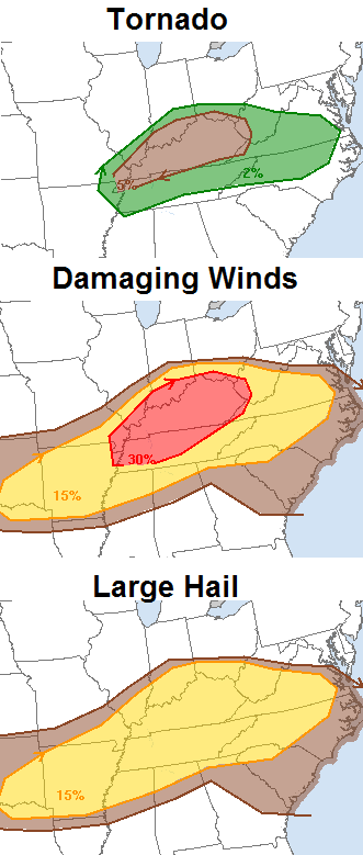
As you can see, damaging winds will continue to be the main threat we have to be on guard for. If we can get some storms to go up on their own ahead of the main cluster this evening, a tornado or two can’t be ruled out. Just like Thursday, showers and storms from early in the day will have a lot to say about how that transpires.
Much of the region is also under a Flash Flood Watch through Saturday morning. We’ve had a lot of rain over the past few weeks and additional totals of 1″-3″ will be possible for some areas. That could cause additional flash flooding concerns.
These storms will also be prolific lightning producers!
The heaviest rains will end early Saturday with windy, cool and showery weather taking over. Temps fall into the 60s for much of the day.
Sunday looks great with sun and 70s for highs after low 50s start the day.
Next week is likely to see additional systems diving in from the northwest, bringing additional heavy rain and storm threats. Temperatures will continue to average below normal through the week and into the 4th of July weekend.
I leave you with your daily dose of severe weather tracking tools…


Today’s risk area

Current watches

Possible watch areas 
Have a great day and take care.

How in the name of ZEUS’S BUTTHOLE did that storm that came through Berea not warrant a Severe Thunderstorm Warning??!!
Roof damage next door? check. High winds? check. hail? check. tree damage? check. So many lightning strikes you’d swear there’s a bi-partisan Presidential candidate debate going on outside? check.
We did finally get a Flash Flood Warning, so I guess we’ve got that going for us, which is nice.
Seems like some may be asleep..Wild lightening and constant thunder but really no warnings except for flooding.We do have a special weather statement now.This lightening is beyond crazy.
I wonder if it’s possible that it could be a severe thunderstorm and they just can’t tell based on radar? I dunno
I do know that lightning (no matter how horrific it is) doesn’t factor into whether or not it’s a warning or not. Wind and hail do obviously.
Our house shook with every boom of thunder and it vibrated for many, many seconds….and my dogs barked each time.
Sleepy person typing!
We must have had some pretty high winds here in Lexington. I have a 30+ oak tree in my backyard and there are some very large limbs laying in my backyard.
0.03 inches of rain in Harlan last night with a good light show to the north and northeast all night long:(
Analogs favor “likely” scenario for severe weather in Kentucky. I found 5 of the top 7 analogs that have us in the mix for severe weather. Could be a long day in the weather office for many television Mets if the atmosphere plays its hand right.
This i wanted to share about severe storms.
I think extreme lightning should be added to severe thunderstorm criteria. Its just as dangerous as wind and hail. If a storm is having an extreme amount of lightning, thats very dangerous. Last storm i can remember seeing like last nights storms was in texas when i lived there for 7 months back in 2012. Wss a loud night here in clay county.
Has to be a mistake…Mesonet site from Warren County at 3:15 cdt has winds of 38 mph with gust of 92mph!
Had to be easily 60-65 mph winds that just moved through South Louisville. It was crazy out.
Had to be easily 60-65 mph winds that just moved through South Louisville. It was crazy out.
4-5 inches rain in Jackson Ohio and still pouring
We just had high winds and dime sized hail for about 10 minutes.
Finally, I am witnessing some truly spectacular storms over Harlan Co…lightning like crazy:) We had a lot of strong wind gusts about 15 minutes ago with no trees down in my yard but a great deal of limb popping sounds where heard while watching in the dark! I will update later to see how much rain I end up receiving as the storms look to be training this evening…super excited:)
Looks like Tennessee storms once again steals the energy from any storms in central ky. Keeping the severe threat away from here.
I am glad as you guys have hogged all the storms lately–LOL. We really do need rain down this way, and we are getting it finally!
I dont know who “you guys” are because I havent had a decent storm my way since April!
Well your general area has had a great deal more rainfall than Southeastern KY, but the main severe storms have probably been a lot more isolated in nature regionally. All I know I have been watching Central KY folk show pictures and write about all of the excessive rainfall and impressive storms for several weeks now while I had 1.5 inches of rain in May and only 1.75 in June until tonight with April averaging about 5 inches–a great deal less than the rest of the state received as reported on the maps!!!