Good Wednesday, everyone. Rounds of showers and thunderstorms will keep on doing their thing over the next several days. We’re pretty much locked into a very stormy setup that is likely to include too much rainfall before all is said and done. This isn’t the ideal forecast heading into the 4th of July weekend.
The threat for scattered showers and storms will be with us again today. Just like before, a few of the boomers could be on the strong side.
Showers and storms may increase in coverage and rainfall intensity Thursday into Friday. That’s with a disturbance rolling eastward across our region. That could put down enough rains to cause some local high water issues.
The systems will keep zipping through here this 4th of July weekend and into early next week. Rainfall numbers from the computer models continue to be very impressive.
The European…
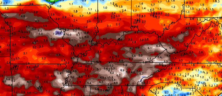
What amounts to the composite rainfall average from the HPC comes up with this over the next week…
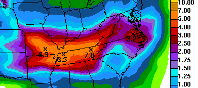
No matter how you slice it, this is a very active storm pattern that will throw a lot of rain our way High water issues are a very real possibility in the coming days.
Temps stay below normal through the weekend with highs potentially staying in the 70s for a few days. After a small spike in thermometers early next week, look out below!
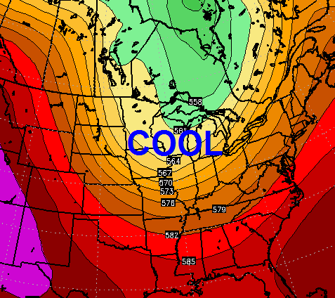 Another deep trough is likely to dig in across the central and eastern parts of the country. That means temps may go back to being solidly below normal for a while.
I said this would be a summer of frequent cold front! 😉
Your daily dose of tracking toys…


Today’s risk area

Current watches

Possible watch areas 
Have a great day and take care.

Yesterday late afternoon, here in northwest Lexington, it POURED rain for quite a bit……..there were also some loud lightning strikes around. I’ve seen much worse, but it rained quite a bit, but I don’t think KLEX got what we got…I looked at the radar and it looked like it was just extreme northwest Fayette.
That’s what makes forecasting summer T-storms so difficult along with causing such discrepancies among the bloggers Mark! Yesterday, I received a tenth of inch of rain while part of my county picked up over an inch just 10 miles to the SE! With some areas getting missed by local and even widespread T-storm events, many get upset, but I think this pattern will eventually give everyone a good dose of rainfall. Believe it or not, it is still a little dry down my way in extreme SE KY. Finally, I am closing in on 4 inches for the month of June which is almost average. It is crazy to think that my area is struggling to reach a normal June rainfall while some parts of Central and Eastern KY are closing in on 10 inches + for the month…
Let’s start July off stormy:)
Nashville TN finished June with 3.38 inches, which is 0.76 below a normal June. But the last few hours of today alone have had a fairly long period of heavy rain, can’t wait to get home to check the rain gauge 😉 .
Lovin’ this weather! Hopefully, the bulk of the precip will fall before 4th of July festivities. But honestly, I’d rather have rain & cool than the triple threat of intense heat, haze & humidity anyday. 🙂
I like some heat in summer, but I too prefer some good ole fashion storms!
In my opinion its been a strange summer so far, not your typical Ohio Valley summer time regime.
A repeat of the last 2 years plus a strong El Nino coming on this year…can’t wait to see what this fall and winter bring…interesting:/
Suppose we are a bit overdue for a stronger El Nino, especially after being stuck in big La Ninas earlier this decade.
This cool is a nice break. I hope it continue until fall
When will you have more on the up coming fall & winter outlook