Good Friday, everyone. We’ve made it to the big 4th of July holiday weekend, but we just can’t shake the showers and thunderstorms. The threat continues across the bluegrass state today and additional high water problems are a real concern… Again.
Another system will cross the region today and ignite more rounds of boomers. A few could be on the strong side, but all of the action will produce some torrential downpours. A Flash Flood Watch continues for many across the region. Your tracking toys in a bit.
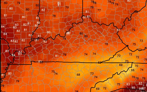
Let’s talk a little bit about the weather for the 4th of July. This does not look like a washout. Yes, we will have rounds of storms, but we should also have some dry times. The greatest concentration looks to be across the southern half of the area. That shows up in the forecast high temps…
Told ya “Hot as the 4th of July” wouldn’t be appropriate to use this year! 😉
Temps will rebound into the 80s area wide from Sunday into the first half of next week. This is normal to below normal for this time of year. The cool shot that had been showing up for the second half of next isn’t looking as cool as before. That’s bad news. Why? It likely means a continuation of the stormy setup…
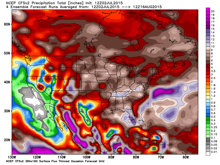
The CFS rainfall forecasts I posted back in May caught a lot of flack from some who never bother to check the forecast range on them. They were 45 day cumulative rainfall forecasts that took us into the first few weeks of July and they did a great job in showing the wet weather we’ve had.
The same model run for the next 45 days show’s a persistent pattern into mid August…
 I leave you with your tracking tools…


Today’s risk area

Current watches

Possible watch areas 
Have a great day and take care.

Hey Chris, You totally pat yourself on the back with this blog sometimes dont you? LOL
He deserves it occasionally
Haha. I was patting the back of the CFS
Thanks Mr. Bailey for all you do! Happy 4th of July!
Thanks Chris! You are all over it.
Happy 4th to all!
Rain, rain, rain, and more rain. Could this pattern yield… snow, snow, snow, and more snow this winter??? We are in a similar weather pattern that was witnessed both last summer and summer before last plus a strong emerging El Nino to boot!!!
Please start including a national radar so that we can see what is headed our way. Thanks for the blog. It is the weather source around here for a lot of people. Thanks
Just go here and click high resolution version in the link below the radar – after that loads, click loop at the top. It covers the entire usa. I use this all the time.
http://www.weather.gov/Radar
More thunder approaching Green River lake. The rain coming down on my houseboat this morning was nice. Just need sun to get in the July 4th mood.
Thanks Chris!
You are all over it.
Happy 4th to All……
Thanks Chris. I think you deserve a bunch of pats on the back for all you do to keep us informed. We’ve had another morning of rain and my gauge dhows a little over half an inch so far. We’ll see what it sYs at the end of the day. Have a great Friday! Stay dry!
Tremendous amount of rain falling in Valley Station at present…been doing so for almost 25 minutes. A line of ’em lit up about an hour or so ago just south of my place it seems.
I get the sense that it is not moving much but the train effect is starting. If the rain calms a little, will report a total soon. A nearby automated rain gauge just south measured over 1.5″ in a short amount of time.
1.25″ in 30 minutes in Valley Station but raining lightly now.
When will farmers have a chance to cut hay in the next two weeks you think Chris?
Thanks Chris.Happy 4th to all.Be safe.
So basically July will end up not being cooler than normal or just the specific cool shot is off the mark?
Thanks Chris. Happy 4th of July to you and your family my friend. Appreciate all that you do for us.
Mesonet site for Hodgenville in LaRue County – 3.89″ in 6 hours!
Kentucky is really taking a beating with excessive rainfall in many areas today!
WOW….Laurel County is getting hammered!
I wish it was Harlan County instead, but still, I have received about 1.5 inches for the event today:)