Good Sunday, everyone. Rounds of thunderstorms are expected to increase today and this action will carry us into the early part of the new week. These storms will be prolific lightning and heavy rain producers and could also cause some wind damage. Without a doubt… the Flash Flood Threat is back into the high category across much of the region.
The models have been really, really underplaying the storms for much of the summer, but these models are even picking up on the potential of the next few days…
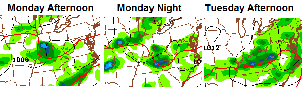
A stalled front will allow for small waves of low pressure to work across our region. With the ridiculous amount of moisture in the air, significant flash flooding is very possible. Exactly when and where will be determined on a storm by storm basis.
I don’t like this setup and will have updates as needed. My @kentuckyweather twitter feed will be busy with warnings and information.
Here are your tracking tools for the day…

Current watches

Possible watch areas 


Have a great day and take care.

It looks like locations generally east of I-75 along that periphery again today. Flash flood and mudslide threats a real danger for the next few days.
Not sure what I would do without this site. No call for rain on local forecasts. No hint at much of anything except higher temps. Then I read here and see there is a storm threat possible for the evening and overnight. Well, that changed my plans a little. Good thing because it poured in buckets with bad lightning and thunder.
“The models have been really, really underplaying the storms for much of the summer”
And that probably says a lot about what I mentioned above. Models underplay and I see underplayed forecasts. 20% chance of rain and we get rain. Even today 20% chance.
Thanks for the updates CB. Really appreciate all that you do.
Can someone tell me how much rain has fallen in june and July for greenup ky, or where I can look this info up. Thanks
Why do we have to keep enduring T-storm warnings and flash flood warnings before we get watches issued this year? I think CB is the only one who is really on-top of the dangerous weather threats this year!!!
Is Louisville in line for heavy rains?
Yes
Thank you! Workplace flooded during last deluge- -need to get prepared.
I’m running out of places to pile all the branches that fall in these storms.