Good Monday, folks. It’s another very active weather day across the commonwealth of Kentucky. Rounds of showers and thunderstorms will continue to rumble across the region and could bring damaging winds and flash flooding.
Here’s a breakdown:
– Storms will continue to come at us in clusters today through Tuesday. It’s not going to rain all the time and we will likely see lengthy breaks between storms. When it does rain… look out.
– There’s the potential for one or more larger complexes of storms to roll across Kentucky. These can up the ante on severe weather.
– Damaging winds and large hail will be possible with any storms that go up.
– The flash flood threat continues to be about as high as you can possible get around here. Additional rainfall amounts may average 1″-3″ over the next couple of days. Much higher amounts will be possible on the local scale.
– Significant flash flooding is possible. When and where will be determined by storm placement.
– A few storms may linger into Tuesday night and Wednesday.
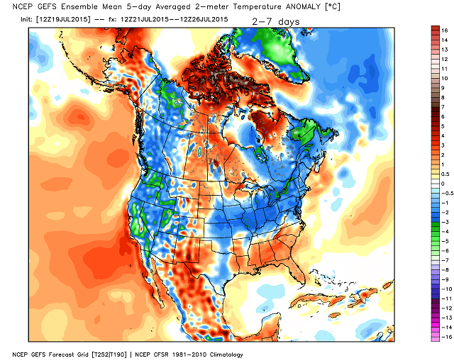
The temperature trend is down for the rest of the week and into the weekend. The GFS Ensembles suggest the numbers come in a little cooler than normal over the next 5 days…
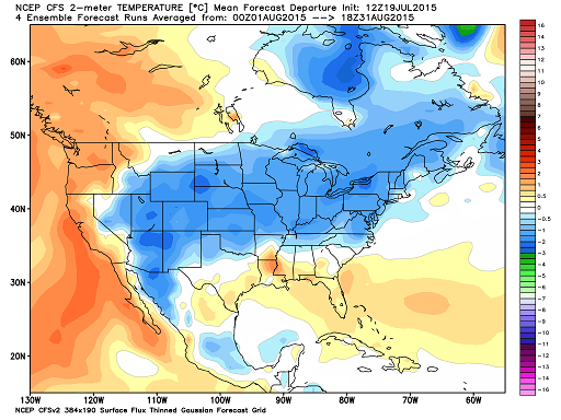
Temps should rebound after that, but the CFS continues to suggest a cooler than normal August…
Does that mean we break the incredibly wet pattern? The CFS says ‘Nah’. The 45 day rainfall forecast keeps showing the heaviest rains falling across our region…
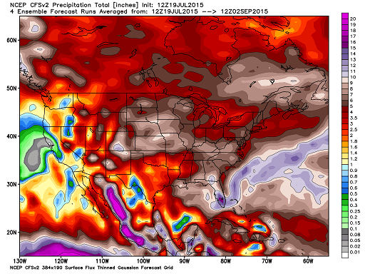
Our record wet summer shows no sign of letting up.
Here are the tracking tools for the day…

Current watches

Possible watch areas 


Have a great day and take care.

Lightning that I captured on my smartphone while recording at 1/8th speed. Storm was at Southern Jackson Co. Northern Laurel County. About 35-40 miles to my south.
http://youtu.be/PPCDJIUyr3c?t=7m37s
Certainly, I am not seeing much wide-spread activity going on compared to last week on a state-wide basis; that is a good thing this time around for those who have been hard hit!
Is there still a threat of hail tonight?.