Good Sunday to one and all. Showers and thunderstorms are getting ready to take on a starring role in our weather over the next week, at least. This happens as another fall cold front makes a run at the bluegrass state by the middle of the week. Yep… it’s getting active again.
Highs today will run in the middle 80s for many with some upper 80s showing up. A scattered shower or thunderstorm will also be possible.
Storm chances increase on Monday as a nice moisture supply increases from the Gulf of Mexico…
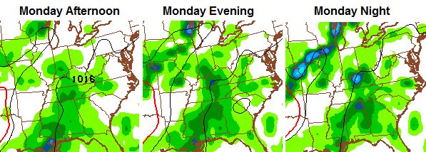
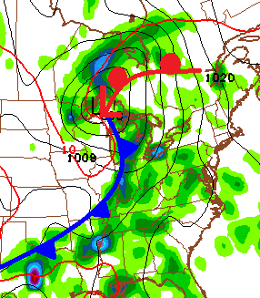
Heavy rainfall is possible with this flow. That trend continues into Tuesday as we await the arrival of our next fall cold front. This looks like a pretty potent system coming out of the plains and into the Great Lakes. That drags the front in here on Wednesday with the potential for some decent storms going up.
GFS
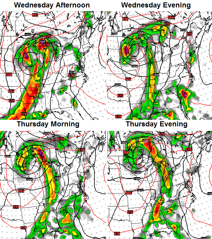
The Canadian Model is even more pronounced with this system, but slows it down across the region on Thursday with a wave of low pressure developing…
Cooler than normal air comes in behind that front and likely hangs around into, at least, early next weekend. Another front will likely move in here for the following week. Active!
Last weekend, I went in depth on the developing El Nino and the potential implications for the fall and winter ahead. I’ve talked about how this would become a behemoth of an El Nino for past few months. Now, NOAA releases a statement on how strong this thing is and the whole weather world flips out.
I’m not going to rehash my thoughts on how different this is from any prior El Nino on record. But I will offer additional support to back up that the warmest anomalies in the Pacific will not be along the coast of South America ala the big El Ninos of 1997 and 1982. The latest from the JAMSTEC…
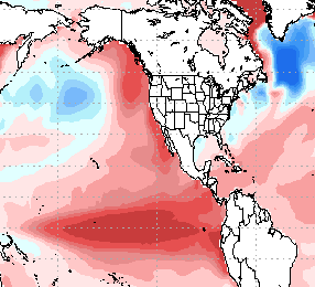
You will also notice all the warm water along the west coast and into the Gulf of Alaska. That’s been there since 2013 and has been, in my eyes, the driving force of the pattern since then. How will that warm water and El Nino get along?
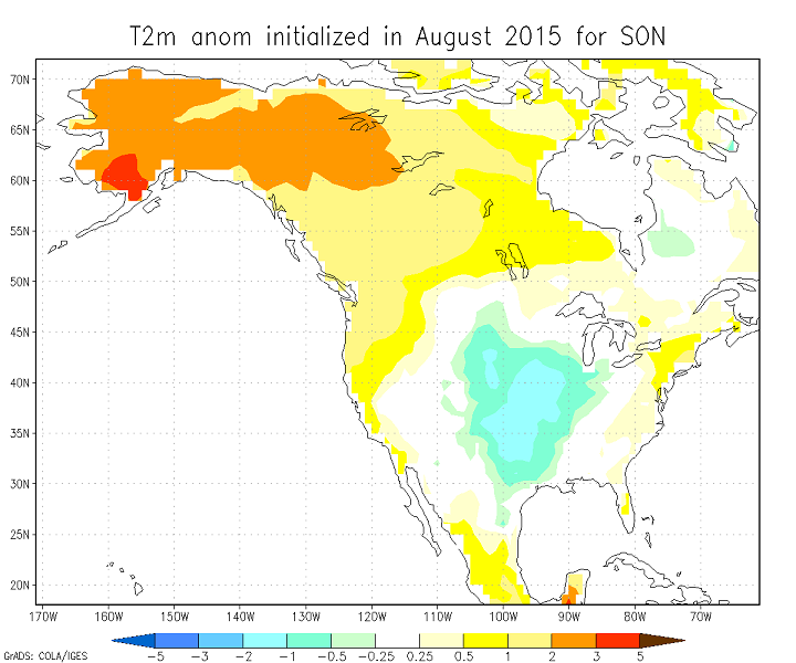
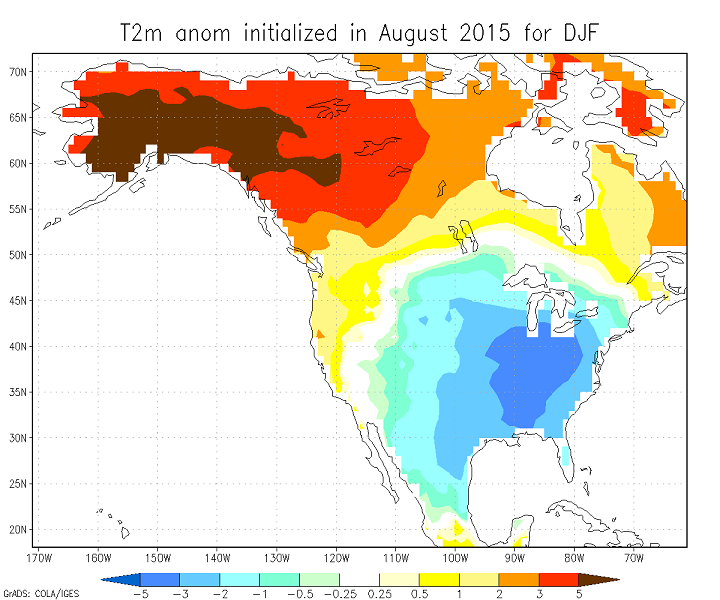
The JAMSTEC fall and winter temperature forecasts continue to indicate colder than normal temps around here…
The model then carries that colder than normal setup through next spring. Sound familiar?
The latest seasonal model from NASA also has a cold look. Fall…
Winter…
Again, those are just seasonal computer models and should be treated with a fair amount of skepticism. The interesting thing is, they all continue to generally point toward a similar setup. LOTS of factors between now and the winter will determine how things play out. There is no true analog to the placement, depth and timing of this monster of an El Nino and overall Pacific setup.
I leave you with some Sunday tracking toys…


Have a great day and take care.

Will be interesting to see if this ends up an active late Fall severe season. 02-03 Niño had the Veteran’s Day outbreak..Dec of 1957 also had outbreaks and it was also a strong Nino..
In our part of the country, La Nina is somewhat more likely to have big spring tornado outbreaks (Winter/Spring 1890, April 3 1974, Spring 2011 and March 2 2012 are good examples) although tornado outbreaks can happen in any spring, La Nina or otherwise.
But I admit I know far less about how autumn tornado outbreaks relate to El Nino/La Nina (known as the El Nino-Southern Oscillation).
Some of us may recall that the fall of 2013 had a notable outbreak across areas of Illinois, western Kentucky among other places. Wife and I were visiting my in-laws in Bowling Green and I sure remember the wicked skies that evening. IIRC, the El Nino-Southern Oscillation was neutral at the time, or in other words between La Nina and El Nino
http://en.wikipedia.org/wiki/November_17,_2013_tornado_outbreak
Showers with obviously bad manners! Staring is impolite.
It’s hard to have much faith in the long-range models since I have not yet seen a woolly worm. 🙂
CB asked above how the warm water off the western coast of the USA/Canada will get along with the current growing El Nino. As Chris touched on the other day, the answer is rather up in the air at this time.
Well, if it turns out to be like Chuck Norris and Bruce Lee working together as a formidable team, could that mean “lights out” this winter?….. 😉
No analog means no true modeling for the upcoming winter…other than late 2013-2014, hard to find any SST maps that look like these. Pay attention to the two primary jet streams (northern and southern branches). Overall, could be stormy south, less wet in the northwest, balmy in the northeast, but what will happen here? Hard to say, make Arctic amplification mad and we get cold, otherwise warmer than average and dry.
The last 2 winters has been cold and some snow. It be interesting what will El nino will throw at us this winter
Then again it may not throw anything at us in our part of country like NOAA is predicting . Just hope it will give west some much needed rain. ask
I hope this means lots of snow for Central Virginia. I also hope like someone else stated that California gets drought relief. We’ll see!